A moderate earthquake struck Iranian Province East Azerbaijan this afternoon (Saturday). USGS gives M 4,8 and a depth of 18 km for this quake. The epicenter lays 66 km northeast of Tabris, where two devasting earthquakes on August 11th 2012 killed more than 300 people.
For this aftershock we can not exclude minor to moderate damage, which is normal if such a quake occurs in Iran, although similar aftershocks last year were harmless. So far, we have got no information from there.
Update: Rescue teams were sent to this area. Telephone lines were disconnected by the earthquake, so that there is currently no possibility to contact the epicenter area.
Update 17.35 UTC: At least two people were injured by the earthquake. Some houses in their village Shahsavar were damaged.(Still no detailed information) There are some other villages where we still have no information about damage or injuries.
Update 18.19 UTC: New reports say there were at least 6 people injured in village Shahsavar. They were carried to medical centers by the Red Crescent rescue team. No details about damage in this and other villages so far.
Update 18.36 UTC: The number of injuries is increasing with every new report. Now there are at least 10 injured persons confirmed.
6 of them were injured due to the stress and panic. The others were injured while running out of their houses. 7 of them were from Shahsavar village. They all were taken to a hospital in Tabris.
There are still no reports of any major damage. There were some damaged houses in Shahsavar and also some minor damages in Tabris. No information from the other villages so far.
Update Jan. 27th: Final reports from Iran say that 34 people were injured by this earthquake. 23 had to go to hospitals in Tabris and Heris. 11 of them (in Tabris and Heris) had a nervous breakdown or problems with blood pressure due to the panic. 13 were injured while running out of their houses. (10 of them came from Shahsavar village). The other 10 had only minor injuries, (also caused by panic, fleeing, etc.) they were treated outpatient.
Small aftershocks continue to rattle this area. Most people don’t go back into their homes yet.
Besides to some minor damage to houses reported earlier there were no more damage.
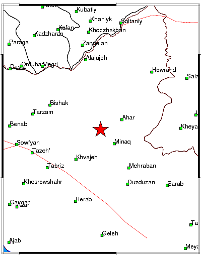
Most important Earthquake Data:
Magnitude : M4.7
Local time at epicenter : 2013-01-26 18:40:49 (local time in Tehran)
Depth (Hypocenter) : 11 km
Geo-location(s) :
21 Km of Varzaghan, East Azarbaijan
22 Km of Ahar, East Azarbaijan
29 Km of Heris, East Azarbaijan
Links to important maps
USGS Did You Feel It Map
Google satellite map showing the epicenter and the surrounding area
| Earthquake NOTIFICATION TWEETS up to your own MAGNITUDE choice | |||
 |
 |
 |
 |
Share your earthquake experience (I Have Felt It) with our readers.
Click on the “I Felt It” button behind the corresponding earthquake
Click here for examples of our “earthquake notifications (button below)”

| SRC | Location | UTC Date/time | M | D | INFO | |
| EMSC | Northwestern Iran | Jan 26 15:10 | 4.6 | 2 | MAP I Felt It | |
|
|
||||||
| GEOFON | Armenia-azerbaijan-iran Border Reg. | Jan 26 15:10 | 4.9 | 10 | MAP I Felt It | |
| USGS | Northwestern Iran | Jan 26 15:10 | 4.8 | 18 | MAP I Felt It | |
a
Earthquake-Report.com headlines on twitter
@OnlyQuakeNews : Get all the headlines of our earthquake-report.com articles + regular updates on ongoing events


Speak Your Mind