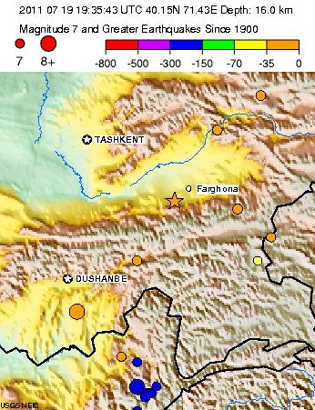
 “Although we already made an effort in explaining a lot in our in-depth article July 19 (click here to read it), we also want to give the USGS seismologists’ view of what exactly happened.”
The July 19, 2011 Kyrgyzstan earthquake is located near the intersection of the borders of Kyrgyzstan, Tajikistan, and Uzbekistan, and was caused by reverse slip, most likely on a south-dipping thrust fault between the Pamir Mountains to the south and the Ferghana basin to the north.
The thrust character of faulting, inferred from the modeling of seismic waves radiated by the earthquake source, is a consequence of north-northwest, south-southeast, oriented compressive stress that ultimately is driven by the northward motion of the India plate as it collides with the Eurasia plate at a rate of more than 40 mm/yr. At the longitude of the earthquake epicenter, the principal boundary between these plates is situated in northern India and Pakistan, over 800 km south of the epicenter, but the convergence produces a broad zone of tectonic deformation that extends more than 1000 km north of the principle plate boundary.
The tectonics of the epicentral region are complex, and both strike-slip and reverse faulting earthquakes have occurred in the vicinity of the July 19 event. A system of thrust faults has been mapped just to the north of this earthquake, near to the Kyrgyzstan-Uzbekistan border, and broad piedmont of alluvial fans that bound the southern margin of the Ferghana basin show abundant evidence of Quaternary deformation.
Historic earthquakes in the immediate vicinity of the July 19 event have been infrequent, with only three earthquakes of M 5.5 or larger within 100 km in the past 40 years; none of those earthquakes are known to have caused fatalities.
Another fault system approximately 100 km to the south, near the southern border of Kyrgyzstan with Tajikistan and China, has been historically more active and an M 5.2 event in 2007, which was about 150 km to the southwest of the July 19 earthquake, caused several fatalities.
In 1983, a M 5.9 earthquake 150 km to the southeast caused in 12 fatalities.
The largest historic event in the region, a M 7.4 earthquake in August 1974, was located approximately 220 km to the east-southeast of the July 19 epicenter. This large earthquake was located close to the epicenter of a M 6.6 earthquake that occurred in October 2008.


