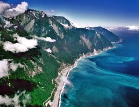
Hualien-Suao coastline - picture courtesy culture.teldap.tw
FINAL UPDATE 14:24 UTC : More reports from other sources do confirm that NO damage has been reported in the greater epicenter area. Taiwan houses are very well build and can take a lot of shaking compared to other countries in the world. Taiwan has a history of very deadly earthquakes and people did improve their earthquake awareness all the time.
We are closing this article and will only reopen it if new important data becomes available.
UPDATE 10:24 UTC : 3 more aftershocks with the following magnitudes : 3.4, 4.1 and 3.9.
UPDATE 10:24 UTC : Focus Taiwan News Channel is reporting that the earthquake left no damage or injuries as far as they could obtain information.
The earthquake was felt as far as Taipei, 140 km from the epicenter.
UPDATE 08:41 UTC : The following train stations and accordingly small villages are nearest to the epicenter : Chongde, Heren, Heping (distance approx. 10 km)
UPDATE 08:30 UTC : So far CWB recorded 3 aftershocks (3.6, 3.2 and 3.8)
A strong earthquake occurred near the shores of the Taiwanese counties of Hualien and Yilan in the beginning of the afternoon (local time). The city of Hualien (pop 108,286) is at a rather safe distance of 34 km.
Taiwan CWB reports a magnitude of Ml 5.5 at a depth of 17 km. According to CWB the max.
MMI values for Hualien County and Yilan County are VI to VII (converted from the CWA scale).Preliminary epicenter location is still problematic as EMSC and USGS are giving different locations
Felt reports out of Taiwan are indicating a IV to V MMI at the western side of the island. We have no Felt reports yet from the greater epicenter area.
Most important Earthquake Data:
Magnitude : Ml 5.5 (CWB)
UTC Time :Â Tuesday, February 01, 2011 at 08:16:31 UTC
Local time at epicenter : Tuesday, February 01, 2011 at 04:16:31 PM at epicenter
Depth (Hypocenter) : 17 km (CWB)
Send an “earthquake experience report” for this earthquake
Geo-location(s) :
30 km (21 miles) NE (49°) from Hualien, Taiwan
50 km (30 miles) S (181°) from Suao, Taiwan
106 km (66 miles) SSE (163°) from T’AIPEI, Taiwan
Links to important maps
USGS Did You Feel It Map
Quake-maps.com satellite map + I Did Feel It form
Alternative satellite map
3-dimensional view of the earthquake area (EMSC epicenter location)
3-dimensional view of the earthquake area (USGS epicenter location)
3-dimensional view of the earthquake area (CWB (Taiwan) epicenter location)
USGS historic earthquakes map
USGS Seismic hazard map
LIVE SEISMOGRAM (Taiwan Seismograph station)
 QuakeSOS+ is an iPhone application developed by Armand Vervaeck, the creator and main contributor to Earthquake Report. The Application simplifies immediate group communication to friends and family members (with your exact GPS location) and is constantly feeding the users with œEarthquake Report news. Together with your own family and friends, QuakeSOS+ will be your closest earthquake friend. Buying QuakeSOS+ will support the activities of SOS Earthquakes.
a
 Quake-Maps.com was also created by SOS Earthquakes. Quake-Maps.com makes it easy to let the world know which shaking people have experienced during the earthquake. Quake-Maps.com gives also the opportunity to write some additional text. Filling up the form takes only 1 minute. Quake-Maps.com gives an overview of all the resent earthquakes and let you even go back in time and retrieve earthquakes of a certain date in the past.
Earthquake-Report.com headlines on twitter
@OnlyQuakeNews : Get all the headlines of our earthquake-report.com articles + regular updates on ongoing events
@QuakeSOS : earthquake-report.com news + automatic earthquake notifications of USGS earthquakes of M 4.0 or higher with emphasis to earthquakes in the America’s and the Pacific Ocean sphere (4 and up) and a lot of the rest of the world (5 and up). This account was created for our QuakeSOS and QuakeSOS+ iPhone applications
@ShakingEarth : earthquake-report.com news + automatic earthquake notifications of EMSC earthquakes of M 4.0 or higher with emphasis to earthquakes in European and Asian / Middle East sphere (4 and up) and a lot of the rest of the world (5 and up). This account was originally created to stimulate our Facebook account
@QuakeMaps : earthquake-report.com news with mapping notifications of ALL earthquakes M 3.0 and higher from all over the world via EMSC and USGS. This account was created for our http://www.quake-maps.com website


Moderate earthquake in the Katowice area, Poland