New additions will always be on top and if the page gets too long, we will cut off part of it and archive it. This url will always be the one to follow.
Leave this page open in a browser tab as it will refresh automatically every 30 minutes
This report is compiled out of many information sources and is brought to you by volcanologist Philippa (Demonte). Armand (Vervaeck) is backing her up as Philippa is sometimes too busy professionally to post updates.
-
Weekly Volcanic Activity Report: 26 September - 2 October 2018
Via Smithsonian Institution - Global Volcanism Program / US Geological Survey's Volcano Hazards Program
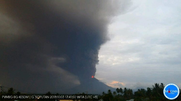
Soputan volcano, Sulawesi, Indonesia in action
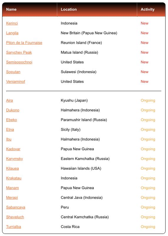
Kerinci | Indonesia
Based on satellite and wind model data, the Darwin VAAC reported that during 28-30 September and 2 October ash plumes from Kerinci rose to an altitude of 4.3 km (14,000 ft) a.s.l. and drifted SW and W.
Langila | New Britain (Papua New Guinea)
Based on analyses of satellite imagery and model data, the Darwin VAAC reported that on 29 September an ash plume from Langila rose to an altitude of 2.4 km (8,000 ft) a.s.l. and drifted NE.
Piton de la Fournaise | Reunion Island (France)
OVPF reported that the eruption at Piton de la Fournaise continued during 26 September-2 October, and tremor levels were stable. The cone continued to grow; one vent was active and ejected spatter. Lava flows were mostly confined to lava tubes, emerging 150-200 m downstream, S of the cone. During a field inspection on 29 September OVPF staff observed a small lava flow at the foot of the cone.
Sarychev Peak | Matua Island (Russia)
KVERT reported that a thermal anomaly over Sarychev Peak was visible in satellite images on 22 September. The Aviation Color Code remained at Orange.
Semisopochnoi | United States
AVO reported that during 19-25 September seismicity at Semisopochnoi remained elevated, alternating between periods of continuous and intermittent bursts of tremor. Tremor bursts at 1319 on 21 September and at 1034 on 22 September produced airwaves detected on a regional infrasound array on Adak Island; no ash emissions were identified above the low cloud deck in satellite data, and the infrasound detections likely reflected an atmospheric change instead of volcanic activity. The Aviation Color Code (ACC) remained at Yellow and Volcano Alert Level (VAL) remained at Advisory.
Soputan | Sulawesi (Indonesia)
PVMBG reported that increased seismicity at Soputan was notable on 2 October, characterized by an increased number of signals indicating emissions and avalanches (which began in September and mid-July, respectively), increased RSAM values, and a higher number of volcanic earthquakes (since September). Data from a thermal camera showed increased summit temperatures, indicating the presence of lava. The Alert Level was increased to 3 (on a scale of 1-4) on 3 October; residents and tourists were advised not to approach the craters within a radius of 4 km, with an additional expansion to 6.5 km in WSW direction due to increased risk from a breach in the crater rim. An eruption commenced at 0847 on 3 October, producing a dense ash plume that rose 4 km above the summit and drifted W and NW. Based on seismic data the event lasted six minutes. Events at 1044, 1112, and 1152 produced ash plumes that rose 2 km, 2.5 km , and 5 km above the crater rim, respectively. A thermal anomaly identified in satellite data significantly increased, and incandescent ejecta at the summit was clearly observed by residents. Avalanches of material traveled 2.5 km down the NE flank.
Veniaminof | United States
AVO reported that the eruption at Veniaminof continued during 26 September-2 October, as evidenced by nighttime incandescence recorded by the FAA web camera in Perryville (35 km S), elevated surface temperatures in thermal satellite data, and elevated tremor levels. A gas plume was occasionally visible during clear daytime conditions. On 26 September lava fountains, visible in webcam images, rose from a second vent located 75 m N of the vent producing lava flows. Minor ash emissions associated with lava fountaining possibly rose as high as km (15,000 ft) a.s.l. and quickly dispersed. The lava flow had traveled 1 km down the S flank of the summit cone by 1 October. The Aviation Color Code remained at Orange and the Volcano Alert Level remained at Watch.
Weekly Volcanic Activity Report: 5-11 September 2018
Via Smithsonian Institution - Global Volcanism Program / US Geological Survey's Volcano Hazards Program
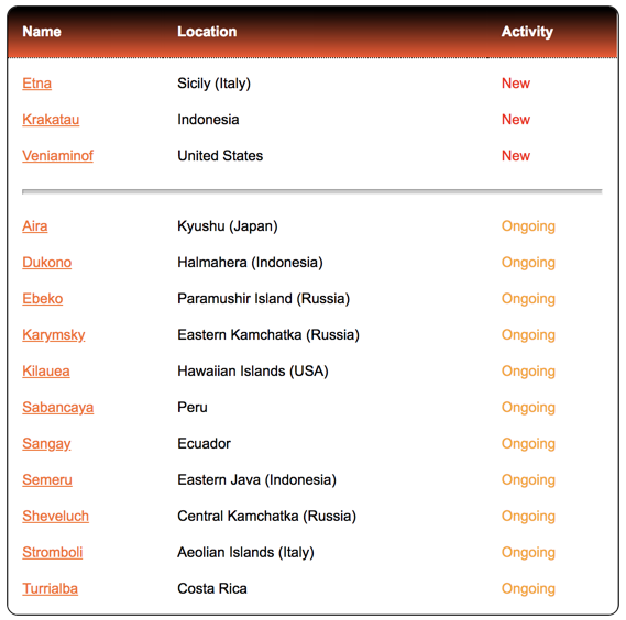
Etna | Sicily (Italy)
INGV reported that during 3-9 September activity at Etna was characterized by gas emissions at the summit craters, with periodic Strombolian activity from vents in Bocca Nuova, Northeast Crater (NEC), and New Southeast Crater (NSEC). A few Strombolian explosions at NSEC were recorded on 5 September; an explosion at 0536 generated an ash plume that produced local ashfall around the vent and in the Valle del Bove, and quickly dispersed. A similar but less intense event occurred earlier that day, at 0316. Similar Strombolian events continued during 6-9 September, at intervals of a few hours. Strombolian activity at the N vent (BN-1) in Bocca Nuova occurred at 3-5-minute intervals, ejecting incandescent material that fell within the crater confines. Gas emissions were sometimes punctuated with ash emissions. Intense degassing was characteristic of the second vent (BN-2). Strombolian activity occurred at NEC, and a few times explosions were accompanied by ash emissions.
Krakatau | Indonesia
Based on satellite data, the Darwin VAAC reported that on 8 September ash plumes from Anak Krakatau rose to altitudes of 4.9-5.5 km (16,000-18,000 ft) a.s.l. and drifted W and NW. During 9-10 September ash plumes rose to 1.5 km (5,000 ft) a.s.l. and drifted W. The Alert Level remained at 2 (on a scale of 1-4); residents and visitors were warned not to approach the volcano within 2 km of the crater.
Veniaminof | United States
On 4 September low-level ash emissions (less than 3 km or 10,000 ft a.s.l.) from Veniaminof were evident in webcam images and confirmed by observers in Perryville (35 km S), prompting AVO to raise the Aviation Color Code to Orange and the Volcano Alert Level to Watch. Seismicity was elevated. During 4-6 September pulsating, low-altitude ash plumes were visible from a Perryville webcam and reported by a pilot, and a small thermal anomaly was visible in satellite data. On 7 September the thermal signal increased, suggesting lava fountaining at the summit. Webcam images the next day showed minor ash or steam near the summit cone. Ash deposits on the snowfield formed a “V” shape from the summit, extending to the SSW and SE. On 9 September a lava flow, about 800 m long, was identified on the S flank in satellite data. Witnesses aboard a ferry passing Veniaminof early the next morning noted lava fountaining and an active lava flow. Lava flows continued on 11 September, though were confined to the summit caldera.
Yasur, Tanna, and Marum, Ambryn | Vanuatu (Philippa)
Thanks to this tip-off from a friend. BBC2 and BBC iPlayer are currently re-screening a programme called 'Kate Humble: Into the Volcano', featuring Yasur volcano, which has frequent Strombolian-style eruptions, and Marum volcano, which has an active lava lake.
via www.bbc.co.uk
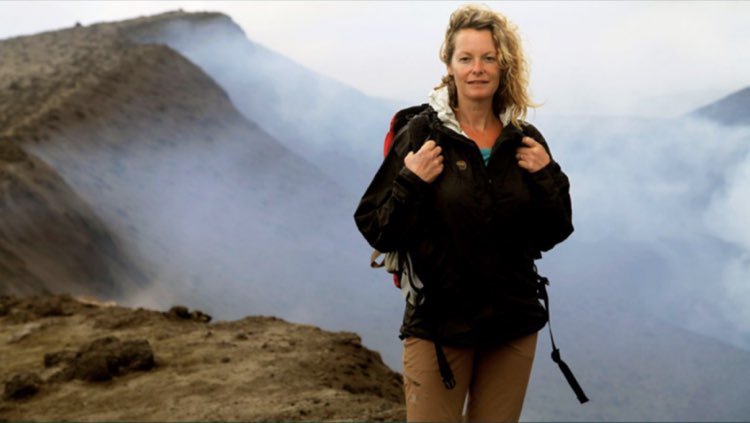
In episode 1, Kate joins geologists Shane Cronin (@scronin70) and Chris Firth on Yasur volcano as they take volcanic gas measurements, capture imagery with a thermal imaging camera, and attempt to get a fresh sample of lava in the form of a pyroclast ('hot rock') / lava bomb ejected from the active vent in order to determine whether the volcano is likely to increase its activity in the near future. Kate also meets people living around Yasur, learning about their relationship with the volcano, and a mixing in a little anthropology and linguistics too.
Click on these links to see 3 clips from Episode 1 (via www.bbc.co.uk):
https://www.bbc.co.uk/programmes/p02g6sqx
https://www.bbc.co.uk/programmes/p02g6t7w
https://www.bbc.co.uk/programmes/p02g6szy
For those of you in the UK, Ireland, and other countries able to access BBC iPlayer, click on this link for the full episode:
https://www.bbc.co.uk/iplayer/episode/b04xx2k5/kate-humble-into-the-volcano-episode-1
Episode 2, which features Kate abseiling down towards the lava lake of Marum, will be re-shown on BBC2 (we think) on the evening of Tuesday 4th September.
Click on these links to see 3 clips from Episode 2 (via www.bbc.co.uk):
https://www.bbc.co.uk/programmes/p02gbtny
https://www.bbc.co.uk/programmes/p02gbxfd
https://www.bbc.co.uk/programmes/p02gbtg9
Manam, Papua New Guinea (Philippa)
As reported last week, the volcanic island of Manam was experiencing a range of different eruptive activities as of 25th August, including lava flows, scoria and ash fall, and pyroclastic density currents (from the collapse of ash plumes). With this activity damaging crops, housing, and limited resources, and polluting the island's drinking water, there are now around 5,000 people on this remote island requiring aid.
Problems have been exacerbated by the fact that according to the Director of the National Disaster Office the communications network that relays monitoring data from instrumentation on the island to Rabaul Volcano Observatory had been down at the time of the initial eruption, and they are currently having to rely upon someone on the island reporting further activity in real time via a mobile phone. (@EMTVOnline). As of 28th August a scientist was en-route to the island with equipment, and government agencies had just reached Manam to make initial assessments.
via The National: https://www.thenational.com.pg/hell-on-manam/
via Scott Waide (@Scott_Waide) / Martha Louis (EMTV journalist):
https://mylandmycountry.wordpress.com/2018/08/27/emtv-journalist-martha-louis-reports-houses-destroyed-people-in-need-of-food-and-water/
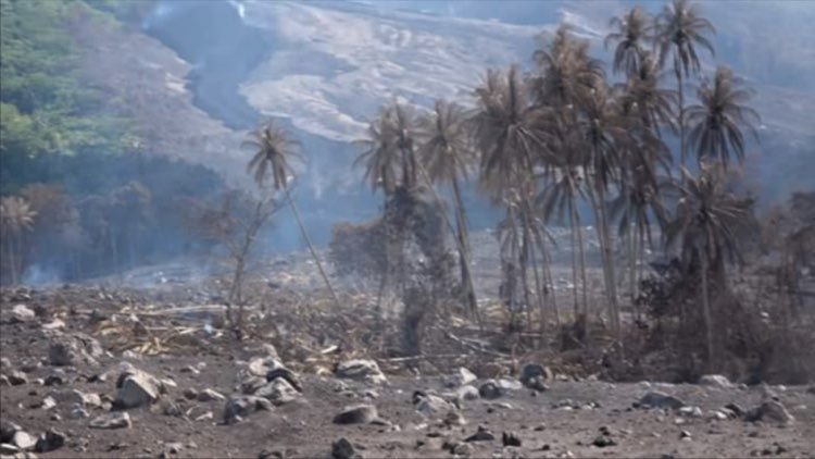
A further report has emerged that four journalists were attacked after entering villages and taking photos in the aftermath of last week's eruptions.
The situation highlights all the difficulties in monitoring volcanic activity in remote parts of the world with limited amounts of resources, getting assessment, assistance and aid in, and in sensitively but informatively reporting such situations.
Krakatau, Indonesia (Philippa)
Apologies for being late to the volcano party...
via Oystein L Andersen (@OysteinLAnderse)
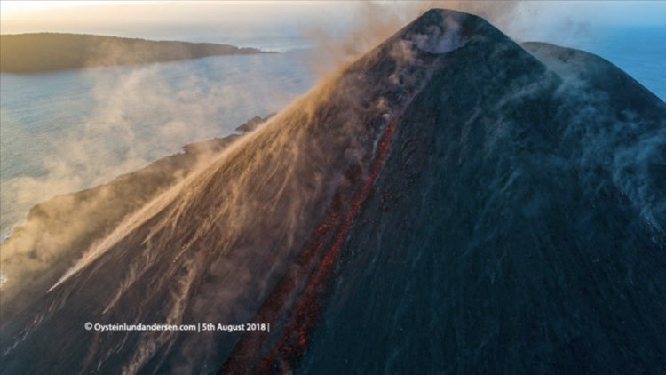
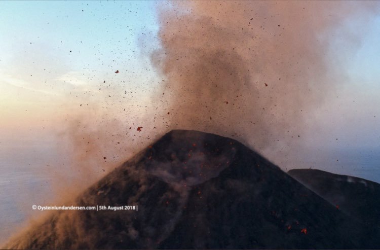
Today 27th Aug. is the 135th anniversary of the 1883 eruption of #Krakatau volcano. It was the 2nd largest in #Indonesia during historical times and caused more than 36000 fatalities. Krakatau is still active. This video shows a eruption at Krakatau earlier this August. pic.twitter.com/Z7Is99o9cH
— Øystein L. Andersen (@OysteinLAnderse) August 26, 2018
Incidentally, the explosive 1883 eruption of Krakatau was one of the loudest in recorded history. It was heard by people as far away as Australia.
Anak Krakatau, a smaller volcano within the larger caldera, has recently been in eruptive phase again. Some stunning images below, taken with a drone-mounted camera since an exclusion zone continues to be in place around the volcano at the moment.
via Oystein L Andersen (@OysteinLAnderse)
Campi Flegrei, Italy (Philippa)
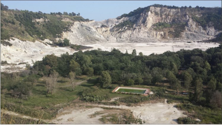
More images coming in from our volcanology friends attending the Cities On Volcanoes conference in Naples, Italy. Most of you know about Vesuvius volcano, but have you heard of the neighbouring Campi Flegrei volcanic fields, which are to Italy what Yellowstone is to the U.S.?
CoV delegate Heather Handley has been posting some volcanic-urban images from around the area. These may look fairly understated and harmless, but it is quite incredible to see tennis courts and swimming pools in what is a volcanic caldera! As Heather explains: "The Campi Flegrei caldera (near Naples) has had about 70 eruptions in the last 15,000 years. The last one took place in 1538 at Monte Nuovo after a volcanic sleep of about 3,400 years."
via Heather Handley (@VMRG_MQ)

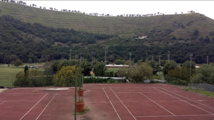
To learn more about Campi Flegrei and other volcanism in the Neapolitan Bay area of Italy, click on this link (via Cities On Volcanoes 10 > Scientific Info):
https://www.citiesonvolcanoes10.com/info-scientifiche/
Mount St Helens (Washington State) + Mount Hood (Oregon), USA (Philippa)
Hands up - who here would like to go on a road trip to Mount St Helens or Mount Hood? You might be interested to know then that the U.S. Geological Survey have just published a new field trip guide for both volcanoes, predominantly focusing on the sedimentary deposits.
Download it from here: https://pubs.usgs.gov/sir/2017/5022/f/sir20175022f_.pdf
Kilauea, Big Island, Hawaii, USA (Philippa)
As someone who was volunteering at the Hawaiian Volcano Observatory back in 2008 when Crater Rim Drive beyond the Jagger Museum had to be closed due to the high levels of volcanic gas emissions, and then witnessing the Overlook Vent within Halema'uma'u Crater coming into being, the rapid changes at the summit of Kilauea volcano from the past few months are astounding!
In the footage below, shot on 26th August 2018 using a drone-mounted camera, we can see that part of Crater Rim Drive** beyond the Jagger Museum has now completely collapsed. This was due to the rapid deflation activity at the summit area, caused by the magma in the system draining down and migrating instead along the Lower East Rift Zone, thus causing downward subsidence within Halema'uma'u Crater. Basically - a smaller caldera has formed within the larger, older caldera of Kilauea volcano.
** You will see a part of the video where Crater Rim Drive goes over an old lava flow. This is directly across the crater from the Jagger Museum.
via USGS Volcanoes (@USGSVolcanoes)
https://twitter.com/USGSVolcanoes/status/1035306576507154432
At the Lower East Rift Zone (LERZ), activity from Fissure 8 still continues to be in pause mode, giving the field geologists from the Hawaiian Volcano Observatory (HVO) to collect samples and make further measurements for analysis.
In other news...it was revealed at the Cities On Volcanoes conference currently taking place in Naples, Italy, that at the height of recent activity at Kilauea volcano, there were just 5 people, a combination of staff from the HVO and other U.S. Geological Survey volcano observatories, working tirelessly around the clock on the social media coverage. In contrast to 2008 when there was just one person in addition to the Chief Scientist who was HVO's point of contact for the media during a period of volcanic crisis, there are now many more social media outlets to be covered and a greater expectation for two-way interaction. What we at Earthquake-Report.com were most impressed with this year were the public meetings with key HVO staff, Civil Defense, and National Park Services staff, which were not only webcast so that local residents who were unable to get to the meetings could still be kept informed, but also featured a sign language interpreter for greater inclusion.
The USGS Volcanoes social media team continue to do a fantastic job in science communication.
Ebeco, Kuril Islands, Russia (Philippa)
Below is one of several images captured of an eruption at Ebeco volcano on 29th August 2018.
via Kirill Bakanov (@WeatherSarov) / Sakhalin.info
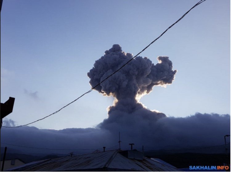
Video footage can also be seen via this link:
https://sakhalin.info/news/157315
Popocatepetl, Mexico (Philippa)
Below is a timelapse GIF of another of Popocatepetl's daily eruptions of volcanic gases, including water vapour. The volcano is currently at Alert Level Yellow.
1st September 2018, 08:25 a.m. local time.
via Geol. Sergio Almazan (@chematierra) / www.webcamsdemexico.com
#FelizSabado #BienvenidoSeptiembre
El #Volcán #Popocatépetl en México amanece con emisión de vapor de agua y cubierto de nieve
Alerta volcánica se mantiene en Amarillo Fase2
Septiembre 1/8:25h pic.twitter.com/PWmaj3Dwql— Geól. Sergio Almazán (@chematierra) September 1, 2018
Bogoslof, Alaska, USA (Philippa)
via Alaska Volcano Observatory (@alaska_avo)
Bogoslof, which was erupting for much of 2017, is B in the #AlaskaVolcanoABCs! This mostly submarine volcano's summit is just barely above the sea level, ~60 mi from Unalaska. On Aug. 15, 2018, AVO geologists visited and saw a steaming, hydrothermally altered vent area and dome. pic.twitter.com/ck2hhzrK1Q
— Alaska AVO (@alaska_avo) August 31, 2018
September 2, 2018
Article: 'To understand volcanoes on other worlds, stand on our own' (Philippa)
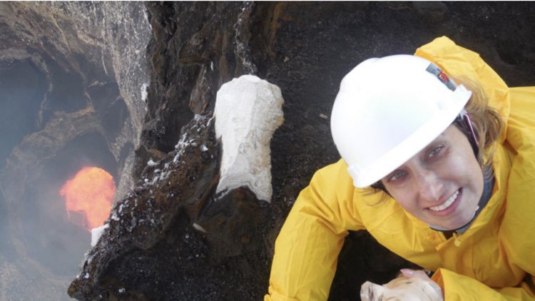
One of our absolute sheroes of volcanology is Rosaly Lopes. She works at NASA's Jet Propulsion Lab (JPL) and studies volcanoes on Earth to try and better understand volcanism on other planets and moons in Outer Space.
Read this article in Quanta magazine about some of the 63 volcanoes that Rosaly has studied to date:
https://www.quantamagazine.org/to-understand-volcanoes-on-other-worlds-stand-on-our-own-20180828/
via Jeannie Curtis (@VolcanoJeannie) - Rosaly Lopes on Ambryn, Vanuatu, in 2014
Mount Etna, Sicily (Italy) (Philippa)
We at Earthquake-Report.com are just a bit jealous of our volcanologist friend Boris Behncke, who's view from his kitchen window is of Mount Etna. As mentioned in the latest Smithsonian report (below), there is currently increased eruptive activity at this volcano in the form of Strombolian-style activity (pyroclasts - i.e. 'hot rocks' being spat out from a vent) and lava flows.
Here are some of the best shots and video footage that Boris has managed to capture this past week.
via Boris Behncke (@etnaboris)
Lava flow from #Etna's New Southeast Crater on the evening of 25 August 2018, seen from Pizzi Deneri, at 2800 m elevation on the northeast flank of the volcano. Very small Strombolian explosions from two closely-spaced vents above the lava source are visible from 00:40 pic.twitter.com/CH2RaZAeNS
— Boris Behncke (@etnaboris) August 26, 2018
... and with this view, I finally fell asleep yesterday evening, after about 36 hours without sleep. Etna's New Southeast Crater, seen from Tremestieri Etneo at 22:25 - 22:35 h on 24 August 2018 pic.twitter.com/VypKGCMiql
— Boris Behncke (@etnaboris) August 25, 2018
Vesuvius, Italy (Philippa)
Brace yourselves, Italy, a flow of volcanologists is headed your way for the Cities On Volcanoes conference, which is this year being held in Naples. We at Earthquake-Report.com are already starting to see the trickle of posts on Twitter featuring glorious views of Vesuvius, including this one below (with thought-provoking comment, which is why this particular conference exists!). Jealous? Us? You bet!
via Heather Handley (@VMRG_MQ)
At Villa Arianna looking towards #Vesuvius #volcano, which was buried by about 3 m of volcanic deposits from the infamous 79 CE eruption. Today ~4 million people live within 30 km of Vesuvius. How do you evacuate that many people? #GeologyOnHoliday #COV10 pic.twitter.com/81FBaeWrZC
— Heather Handley (@VMRG_MQ) August 29, 2018
NOTE: Vesuvius is a mere volcanic pimple on the landscape compared to the neighbouring Campi Flegrei volcanic fields, Italy's very own 'super volcano'.
Mount Yasur, Tanna Island, Vanuatu (Philippa)
via Benjamin Simons (@dread_rocks)
2 hours in 30 seconds #Yasur #volcano #timelapse pic.twitter.com/xJOlDhR6j1
— Benjamin Simons (@dread_rocks) August 29, 2018
Eyjafjällajökull, Iceland (Philippa)
If any of you live in the UK, specifically - in or near Hull, make a note in your diaries. Volcanologist Dr Evgenia Ilyinskaya, who most recently did volcanic gas sampling field work at Kilauea volcano in Hawaii, will be giving a guest talk on 12th September about the 2010 eruption of Eyjafjällajökull volcano. The talk will take place at 3.00 p.m. in Teaching Room 2 in the Brynmore Jones Library.
Eyjafjallajökull isn’t just a pain to say, it caused a lot of pain in 2010 when it disrupted travel plans across Europe. But volcanoes affect far more than our travel plans, as volcanologist @eilyinskaya will show at #BSF18. Find out more at: https://t.co/2FtN7j8Cil pic.twitter.com/KpKBtIFPIm
— British Science Fest (@BritishSciFest) August 29, 2018
To register your attendance, go to this link:
https://www.britishsciencefestival.org/event/volcanoes-and-air-pollution/
Timanfaya National Park, Lanzarote, Canary Islands (Philippa)
Fantastic to see what the latest batch of INVOLCAN's summer interns are up to on various different Canary Islands.
We here at Earthquake-Report.com particularly appreciate this one, which is at the fantastic Timanfaya National Park, where you can see relatively young lava flows (from the past 200 years) in what looks like a lunar landscape. There is still heat coming out from below to the extent that there is actually a barbecue restaurant at the visitors centre for the park.
Our soil temperature readings reached above 100°C in #Timanfaya National Park today. Hot enough to cook chicken on, which we ate after a long day collecting more gas samples! @cutler_kyra @GeoIntern @GeoTenerife #Lanzarote #volcano #chicken pic.twitter.com/nGZOvSIHBE
— Elinor Meredith (@elinormere) August 29, 2018
Meanwhile, intern Ollie Davies has been learning more about seismology and how spectrograms (analysis of the frequency content of the 'sound'waves which travel through the ground) are used to detect and monitor different types of earthquakes.
The first image below shows a detected volcano-tectonic event, a little quake generated as magma tries to break through bedrock underground.
The second image below shows a regular tele-seismic Earthquake, which is generated by some kind of stick-slip activity at a fault some distance away.
via Ollie Davies (@geolliegy)
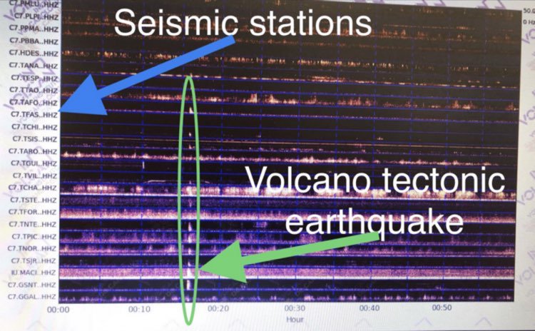
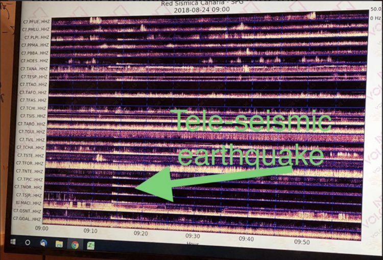
NOTE: It is not clear from Ollie's images which of the Canary Island's seismometers these signals were recorded at. We are guessing though this is the network on Tenerife, which is where INVOLCAN's main observatory is based.
Kilauea, Big Island, Hawaii, USA (Philippa)
via USGS Volcanoes (@USGSVolcanoes)
https://twitter.com/USGSVolcanoes/status/1034917145027567616
Aniakchak, Alaska, USA (Philippa)
School's starting & we're kicking off the #AlaskaVolcanoABCs! We'll tour a subset of volcanoes in AK, featuring one for every letter & starting with Aniakchak. This volcano, located on the AK Peninsula, last erupted in 1931 and has a 10 km wide, 1 km deep caldera. @AniakchakNPS pic.twitter.com/fTgzND4loU
— Alaska AVO (@alaska_avo) August 28, 2018
Volcan Fuego, Guatemala (Philippa)
CONRED, which is the national disaster relief agency in Guatemala, report that there have been several lahars (volcanic 'mud'flows) generated this week around Volcan Fuego due to heavy rainfall re-mobilising volcanic ash from eruptions earlier this year.
The latest report, issued yesterday (29th August 2018) stated that in addition to volcanic ash, the lahars were also re-mobilising giant blocks (~2-3 m in diameter), tree trunks and branches along previously dry ravines and tributaries of the River Pantaleon.
Workers in the immediate vicinity have been evacuated as a precautionary measure, and further lahars are expected due to the meteorological conditions this week.
via CONRED (@ConredGuatemala)

Sabancaya, Peru (Philippa)
A nice little time-lapse video below from (Peruvian volcano monitoring agency) OVI INGEMMET of activity at Sabancaya volcano in Arequipe. Although this footage was from 24th August 2018, this is typical of the daily activity at Sabancaya: explosions of volcanic gas slugs (volcano 'farts') and volcanic ash, with plumes reaching up to around 4.5 km above the crater.
via OVI INGEMMET (@oviingemmet)
En el siguiente video se puede apreciar las explosiones ocurridas esta mañana en el volcán #Sabancaya #Arequipa cuyas columnas alcanzaron los 4.5 km sobre el cráter del macizo pic.twitter.com/wqmtw9tEd9
— OVI (@oviingemmet) August 24, 2018
Weekly Volcanic Activity Report: 22-28 August 2018
Via Smithsonian Institution - Global Volcanism Program / US Geological Survey's Volcano Hazards Program
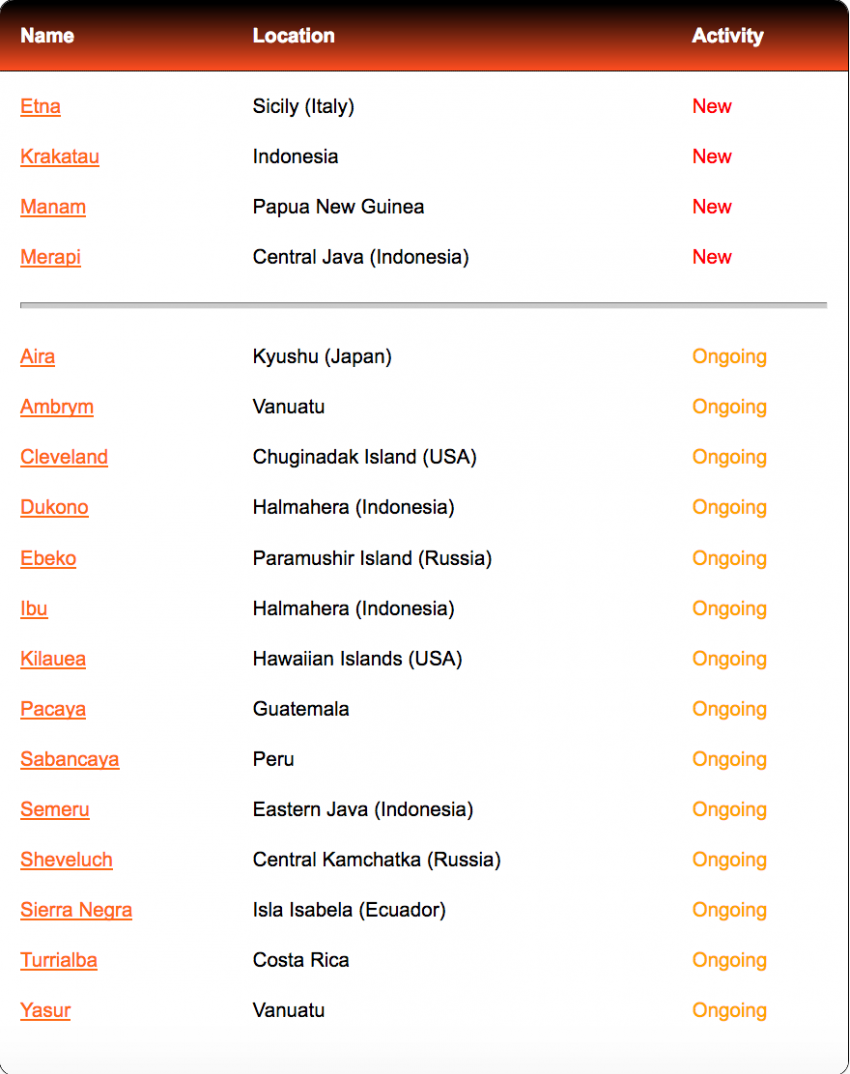
Etna | Sicily (Italy)
(Italian volcano monitoring agency) INGV reported that during 20-26 August activity at Etna was characterized by gas emissions at the summit craters, Strombolian activity, and ash emissions. Strombolian explosions continued from vents in Bocca Nuova (including from a vent that had opened on 16 August) and Northeast Crater (NEC). Activity at New Southeast Crater (NSEC) was characterized by modest and occasional explosions and Strombolian activity. Beginning at 17:00 on 23 August, Strombolian activity from the cone in the saddle between the Southeast Crater (SEC) and NSEC cone complex rapidly intensified; explosions ejected tephra 100-150 m above the vent rim. At 17:30 Strombolian activity occurred at NSEC's East vent and a lava flow from the same vent traveled a few hundred meters towards the Valle del Bove. Just after 17:30, lava overflowed the vent in the saddle cone and flowed northwards; Strombolian activity at that vent continued through the night and then stopped no later than 06:20 on 24 August. AT 06:22, Strombolian activity from a vent on the southern flank of NSEC produced a small lave flow that traveled a few dozen meters. During 25-26 August the activity at the saddle cone gradually decreased, and ash emissions were weak and occasional.
Krakatau | Indonesia
(Indonesian volcano monitoring agency) PVMBG reported that at 18:07 on 23 August an event at Anak Krakatau generated a dense, black ash plume that rose about 700 m above the crater rim. Based on satellite data, the Darwin Volcanic Ash Advisory Centre (VAAC) reported that during 27-28 August ash plumes rose to altitudes of 1.2-1.5 km (4,000-5,000 ft.) above sea level and drifted SW and SWS. The Alert Level remained at 2 (on a scale of 1-4); residents and visitors were warned not to approach the volcano within 2 km of the crater.
Manam | Papua New Guinea
Rabaul Volcano Observatory (RVO) reported that an eruption at Manam began at around 06:00 on 25 August after island residents reported increased activity beginning and hour before. According to the Darwin VAAC, ash plumes visible in satellite data rose to 15.2 km (50,000 ft.) above sea level and drifted WSW. The plume drifted W and NW, causing ash and scoria to fall in areas from Dangale in the NNE to Jogari in the SW part of the island. The most affected areas were Baliau and Kuluguma; residents reported fallen tree branches from the deposits, and conditions so dark that flashlights were needed to move around. Lava flows traveled down the NE valley and pyroclastic flow deposits were evident in the NE valley all the way to the sea. The pyroclastic flows buried six houses in Boakure village though the occupants escaped to the nearby Abaria village. According to a news article, about 2,000 people evacuated. The eruption ceased around 10:30 with dense white emissions visible afterwards. During brief periods of good visibility after the eruption, and through 26 August, observers noted dense white vapour emissions and occasional light grey ash plumes.
Merapi | Central Java (Indonesia)
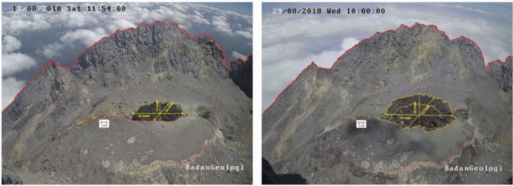
PVMBG reported that the new lava dome within the fracture of Merapi's 2010 dome grew at a rate of 4,300 cubic meters per day during 18-28 August, and by 28 August the volume of the lava dome was an estimated 44,000 cubic meters. The Alert Level remained at 2 (on a scale of 1-4), and residents were warned to remain outside of the 3-km exclusion zone.
via PVMBG (@BPPTKG)
UPDATE! (Philippa)
The latest report from PVBMG (released 29th August 2018) states that the new lava dome is growing at a rate of around 5,300 m^3 per day, which is a slightly higher rate than stated in the Smithsonian report. This is nevertheless considered by the Indonesian volcano monitoring agency to be a low rate, and the position of this new lava dome growth is stable.
August 30, 2018
Kilauea, Big Island, Hawaii, USA (Philippa)
The U.S. Geological Survey Volcanoes report as of yesterday (21st August 2018) was as follows:
via USGS Volcanoes
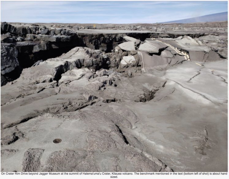
"Parts of the Kilauea caldera floor are now a jumble of down-dropped blocks and surface cracks. The Hawaiian Volcano Observatory (HVO) field crews carefully hiked along Crater Rim Drive yesterday afternoon to verify the locations of USGS benchmarks (lower left), which will be used for additional geophysical work that will help document the recent summit changes. The view is to the northwest with one flank of Mauna Loa visible in the distance (upper right).
Seismicity and ground deformation continue to be negligible at the summit of Kilauea volcano. On the volcano's lower East Rift Zone (LERZ), only a few ocean entries are oozing lava; laze plumes are minimal. Sulfur dioxide emission rates at both the summit and LERZ are drastically reduced; the combined rate is lower than at any time since late 2007. The Hawaiian Volcano Observatory will continue to closely monitor Kilauea's seismicity, deformation, and gas emissions for any sign of reactivation, and maintain visual surveillance of the summit and LERZ, issuing daily updates and messages as needed."
Weekly Volcanic Activity Report: 15-21 August 2018
Via Smithsonian Institution - Global Volcanism Program / US Geological Survey's Volcano Hazards Program
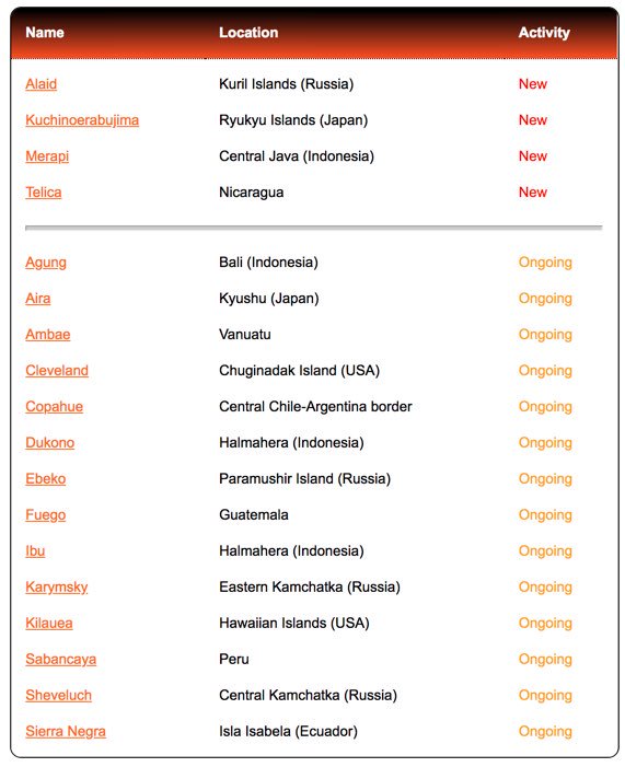
Alaid | Kuril Islands (Russia)
The Tokyo Volcanic Ash Advisory Centre (VAAC) reported that on 20 August an ash plume from Alaid identified in satellite images rose to an altitude of 2.7 km (9,000 ft.) above sea level and drifted south east.
Kuchinoerabujima | Ryukyu Islands (Japan)
The Japanese Meteorological Agency (JMA) reported that earthquakes of Kuchinoerabujima's Shindake Crater typically occur at shallow levels, though on 15 August a swarm of deep volcanic earthquakes was recorded, prompting JMA to raise the Alert Level to 4 (on a scale of 1-5). The earthquake hypocenters were about 5 km deep, below the SW flanks of Shindake, and the maximum magnitude was 1.9. They occurred at about the same place as the swarm that occurred just before the May 2015 eruption. Sulfur dioxide emissions had been increasing since the beginning of August, they were 1,600, 1,000, and 1,200 tons/day on 11, 13, and 17 August, respectively. No surficial changes in gas emission or thermal areas were observed during 16-20 August.
Merapi | Central Java (Indonesia)
(Indonesian volcano monitoring agency) PVMBG reported that seismicity at Merapi increased on 18 July and again on 29 July. On 11 August a large earthquake was detected, and coupled with rumbling heard by Deies residents, possibly signaled new lava-dome effusion. Drone photos on 12 August showed a new lava dome growing within the fracture of the 2010 dome. By 18 August the new dome was 55 m long and 25 m wide, and about 5 m below the 2010 dome surface. The Alert Level remained at 2 (on a scale of 1-4) and residents were warned to remain outside the 3 km exclusion zone.
Telica | Nicaragua
(Nicaraguan volcano monitoring agency) SINAPRED reported that on 15 August an explosion at Telica generated an ash plume that rose 200 m above the crater rim.
Weekly Volcanic Activity Report: 8-14 August 2018
Via Smithsonian Institution - Global Volcanism Program / US Geological Survey's Volcano Hazards Program
Etna | Sicily (Italy)
(Italian volcano monitoring agency) INGV reported that during 6-12 August activity at Etna was similar to the previous week, characterized by gas emissions at the summit craters, Strombolian activity, and ash emissions. Strombolian explosions continued from vents in Bocca Nuova, and were particularly visible at night. Activity at Northeast Crater (NEC) consisted of frequent ash emissions and Strombolian explosions. Explosions at the E crater on the E flank of the New Southeast Crater (NSEC) generated gray-brown ash plumes that sometimes rose several hundred meters above Etna's summit and quickly dissipated.
Geologic Summary: Mount Etna, towering above Catania, Sicily's second largest city, has one of the world's longest documented records of historical volcanism, dating back to 1500 BCE. Historical lava flows of basaltic composition cover much of the surface of this massive volcano, whose edifice is the highest and most voluminous in Italy. The Mongibelio stratovolcano, truncated by several small calderas, was constructed during the late Pleistocene and Holocene over an older shield volcano. The most prominent morphological feature of Etna is the Valle del Bove, a 5 x 10 km horseshoe-shaped caldera open to the east. Two styles of eruptive activity typically occur, sometimes simultaneously. Persistent explosive eruptions, sometimes with minor lava emissions, take place from one or more summit craters. Flank vents, typically with higher effusion rates, are less frequently active and originate from fissures that open progressively downward from near the summit (usually accompanied by Strombolian eruptions at the upper end). Cinder cones are commonly constructed over the vents of lower-flank lava flows. Lava flows extend to the foot of the volcano on all sides and have reached the sea over a broad area on the SE flank.
Great Sitkin |Andreanof Islands (USA)
The Alaska Volcano Observatory (AVO) reported that a small phreatic explosion at Great Sitkin was recorded by the seismic network at 11:05 on 11 August. The event was preceded by small local earthquakes. Cloudy satellite images prevented views of the volcano during 12-14 August. The Aviation Color Code remained at Yellow and the Volcano Alert Level remained at Advisory.
Geologic Summary: The Great Sitkin volcano forms much of the northern side of Great Sitkin Island. A younger parasitic volcano capped by a small, 0.8 x 1.2 km ice-filled summit caldera was constructed within a large late-Pleistocene or early Holocene scarp formed by massive edifice failure that truncated an ancestral volcano and produced a submarine debris avalanche. Deposits from this and an older debris avalanche from a source to the south cover a broad area of the ocean floor north of the volcano. The summit lies along the eastern rim of the younger collapse scarp. Deposits from this and an older debris avalanche from a source to the south cover a broad area of the ocean floor north of the volcano. The summit lies along the eastern rim of the younger collapse scarp. Deposits from an earlier caldera-forming eruption of unknown age cover the flanks of the island to a depth of 6 m. The small younger caldera was partially filled by lava domes emplaced in 1945 and 1974, and five small older flank lava domes, two of which lie on the coastline, were constructed along northwest- and NNW-trending lines. Hot springs, mud pots, and fumaroles occur near the head of Big Fox Creek, south of the volcano. Historical eruptions have been recorded since the late 19th Century.
Nevados de Chillan | Chile
Servicio Nacional de Geologica and Mineria (SERNAGEOMIN), Observatorio Volcanologico de Los Andes del Sur (OVDAS), and (National Disaster Agency) ONEMI reported that at 12:12 on 8 August an explosion-type earthquake was recorded by Nevados de Chillan's seismic network. A greyish ash plume rose 1.5 km above Nicanor Crater and incandescent material was ejected around the vent. The Alert Level remained at Orange, the second highest level on a four-colour scale, and residents were reminded not to approach the crater within 3 km. ONEMI maintained an Alert Level Yellow (the middle level on a three-colour scale) for the communities of Pinto, Coihueco, and San Fabian.
Geological Summary: The compound volcano of Nevados de Chillan is one of the most active of the Central Andes. Three late-Pleistocene to Holocene stratovolcanoes were constructed along a NNW-SSE line within three nested Pleistocene calderas, which produced ignimbrite sheets extending more than 100 km into the Central Depression of Chile. The largest stratovolcano, dominantly endesitic, Cerro Blanco (Volcan Nevado), is located at the NW end of the group. Volcan Viejo (Volcan Chillan), which was the main active vent during the 17th-19th Centuries, occupies the SE end. The new Volcan Nuevo lava dome complex formed between 1906 and 1945 between the two volcanoes and grew to exceed Volcan Viejo in elevation. The Volcan Arrau dome complex was constructed SE of Volcan Nuevo between 1973 and 1986 and eventually exceeded its height.
Rincon de la Vieja | Costa Rica
(Costa Rican volcano monitoring agency) OVSICORI-UNA reported that a three minute long eruption at Rincon de la Vieja began at 18:28 on 14 August. Foggy conditions prevented webcam views and an estimate of a plume height.
Geologic Summary: Rincon de la Vieja, the largest volcano in NW Costa Rica, is a remote volcanic complex in the Guanacaste Range. The volcano consists of an elongated, arcuate NW-SE-trending ridge that was constructed within the 15 km wide early Pleistocene Guachipelin caldera, whose rim is exposed on the south side. Sometimes known as the 'Colossus of Guanacaste', it has an estimated volume of 130 km^3 and contains at least nine major eruptive centres. Activity has migrated to the SE, where the youngest-looking craters are located. The twin cone of 1916m high Santa Maria volcano, the highest peak of the complex, is located at the eastern end of a smaller, 5 km wide caldera and has a 500 m wide crater. A plinian eruption producing the 0.25 km^3 Rio Blanca tephra about 3500 years ago was the last major magmatic eruption. All subsequent eruptions, including numerous historical eruptions possibly dating back to the 16th Century, have been from the prominent active crater containing a 500m wide acid lake located ENE of Von Seebach crater.
August 23, 2018
Hmm is anyone else encountering problems with the images on this blog
loading? I'm trying to determine if its a problem on my end or if
it's the blog. Any suggestions would be greatly appreciated.
Hi, At least here everything works normally
Are there any volcanic action around Mexico City?
Popocatepetl volcano, active all the time
Perfekt