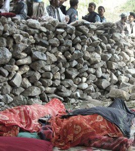
Earthquake overview : A strong earthquake has occurred near to populated areas in Baghlan. Some damage is expected.
Tell us when you think you have felt this earthquake.
Afghanistan-only earthquake list
Keep this page open to read more details when they become available
On 6/11/2012 5:02:17 AM UTC (about 09:32h local time) an earthquake of magnitude 5.4 occurred in the highly populated region of Baghlan in Afghanistan. The earthquake happened 169km from Kabul.
27 minutes later, a stronger shallower earthquake has occurred. Most people would have been out of their house by the second quake, reducing casualty potential.
IMPORTANT UPDATE 09:30 UTC - 18th June 2012: The search party has been officially called off.
71 fatalities have occurred in the town and it will remain buried as a mass grave.
IMPORTANT UPDATE 18:30 UTC - Day 2 - 12th June 2012: Good news - officials on site have calculated that only around 50 are buried rather than the 100-140 calculated previously. This is still of course an unfortunate death toll.
IMPORTANT UPDATE 11:30 UTC - Day 2 - 12th June 2012 :
Jawed Basharat has said that "A massive landslide of mud and rocks buried houses so deep in the remote mountain village of Sayi Hazara that rescuers have given up trying to use shovels to dig through the buried buildings. There were no visible signs of the buildings underneath.
- Bulldozers and other machinery is needed to remove the earth and get the bodies out - or the survivors if any. - Rescuers only currently have 1 bulldozer.
- They knew how many houses were buried only from information provided by area residents, who said between 25 and 30 houses disappeared in the landslide.
- 5 bodies have been found as of now.
- United Nations has said that it was helping Afghanistan authorities in the area to determine what aid was needed.
IMPORTANT UPDATE 15:30 UTC :
- at least 80 are presumed dead in a yungay 1970 style landslide. This total could be up to 140 depending on the population in the 20+ buildings covered.
- Rescuers have so far pulled two bodies of women from the rubble of the landslide in Baghlan province and expect many others were buried.
- Afghanistan officials said on Monday that some 70 people were trapped in rubble after mud houses collapsed from two strong earthquakes. Landslides typically cause many deaths from earthquakes.
- The U.N. confirmed one other death and said houses were destroyed across five districts.
IMPORTANT UPDATE 13:30 UTC :
- 3 people have been confirmed dead so far
- More than 20 houses have been buried in a landslide .
- some mud houses have been severely damaged
- Afghan SAR forces are searching the rubble to find corpses and even more survivors of the earthquake.
- Similar earthquakes in the past have also been devastating and caused a lot of fatalities
- 10 houses had been destroyed in Ishkamish district in neighbouring Takhar province. No news of injured or death from this area.
UPDATE: The earthquake has been felt III in Kabul, and III-IV in Bagram Airfield (about 120-130km from the earthquake epicenter)
UPDATE: We hope to get some confirmation from military forces in the area as to the effects of this earthquake.
UPDATE: 50 deaths and 150 injuries were seen from a 2002 earthquake occurring very close to the present epicenter with Mw5.8. Almost 1200 fatalities were also seen from the 25 March 2002 event. (The number of fatalities in this earthquake was uncertain due to political situation in Afghanistan at the time of the earthquake. However, United Nations figures estimate approximately 1,200 fatalities in the Nahrin region with at least 100 deaths in the town of Nahrin itself. Another 7,000 people were injured and more than 20,000 were rendered homeless. Many of the injured were flown out by helicopter to the neighbouring towns of Baghlan and Pol-e Khomri.) - ASC-India.
UPDATE: The CATDAT Damaging Earthquakes Database has seen over16 damaging earthquakes within 100km of the epicenter since 1900. An earthquake in 1972 in Baghlan of Mw6.4, a destructive earthquake in north Afghanistan occurred. It destroyed approximately 7,000 houses, killing 450 and injuring 3,000 people in the Baghlan district. The shock caused serious damage and loss of life in the coal mines in the district. The earthquake was felt as far as Tashkent, Murgab and Tarbela, over an area of a radius of 520 km.
UPDATE: The earthquake was felt strongly in Baghlan Province. PAGER is indicating only a 35% chance of fatalities.
An earthquake of magnitude 5.6 occurred in the highly populated region of Baghlan in Afghanistan. The earthquake happened 173km from Kabol. The nearest populated places are: Gavmordeh (12km), Wuch (15km), Daragi (17km), Pashakhana (7km), Godri (5km), Gozar-e Langar (18km), Nahrin (17km), Safedreg (18km), Saqaw (13km), Chashmeh-ye Rabat (13km), Gawmurda (14km), Larak (10km), Akakhel (17km). The closest civilian airport is Kunduz (74km).
Most important Earthquake Data:
Magnitude : 1st- 5.4 Mb AND 2nd- 5.6 Mw
UTC Time : 05:02:17AM, Monday, June 11th, 2012 AND 05:29:14AM, Monday, June 11th, 2012
Local time at epicenter : 09:32:17AM, Monday, June 11th, 2012 AND 09:59:14AM, Monday, June 11th, 2012
Depth (Hypocenter) : 49km (USGS) AND 31km (USGS)
Geo-location(s) : The nearest populated places are: Yakhpaj (19km), Khoshkak (17km), Gavmordeh (8km), Wuch (14km), Daragi (14km), Pashakhana (6km), Godri (2km), Gozar-e Langar (19km), Nahrin (15km), Aqsay (20km), Saqaw (13km), Chashmeh-ye Rabat (16km), Gawmurda (16km), Larak (13km), Akakhel (20km). The closest civilian airport is Kunduz (77km).
Links to important maps (data from strongest earthquake)
USGS Did You Feel It Map
Google satellite map showing the epicenter and the surrounding area
Historic earthquakes map
Seismic hazard map
Shaking map
Scientific parameters
Human impact map
Click here for examples of our "earthquake notifications (button below)"

| SRC | Location | UTC Date/time | M | D | INFO | |
| GEOFON | Hindu Kush Region, Afghanistan | Jun 11 08:32 | 4.4 | 10 | MAP I Felt It | |
| EMSC | Hindu Kush Region, Afghanistan | Jun 11 08:32 | 4.3 | 20 | MAP I Felt It | |
| USGS | Hindu Kush Region, Afghanistan | Jun 11 08:32 | 4.2 | 10 | MAP I Felt It | |
| USGS | Hindu Kush Region, Afghanistan | Jun 11 05:29 | 5.7 | 15 | MAP I Felt It | |
| GEOFON | Hindu Kush Region, Afghanistan | Jun 11 05:29 | 5.7 | 10 | MAP I Felt It | |
|
|
||||||
| EMSC | Hindu Kush Region, Afghanistan | Jun 11 05:29 | 5.7 | 30 | MAP I Felt It | |
|
|
||||||
| EMSC | Hindu Kush Region, Afghanistan | Jun 11 05:02 | 5.4 | 40 | MAP I Felt It | |
| USGS | Hindu Kush Region, Afghanistan | Jun 11 05:02 | 5.4 | 15 | MAP I Felt It | |
|
|
||||||
| GEOFON | Hindu Kush Region, Afghanistan | Jun 11 05:02 | 5.4 | 10 | MAP I Felt It | |
a

QuakeSOS+ and QuakeSOS free are iPhone applications developed by Armand Vervaeck, the founder of Earthquake Report. The Application simplifies immediate group communication to friends and family members (with your exact GPS location) and is feeding the users with Earthquake Report news. The 0.99 US$ QuakeSOS+ version will support the activities of SOS Earthquakes.
a
Earthquake-Report.com headlines on twitter
@OnlyQuakeNews : Get all the headlines of our earthquake-report.com articles + regular updates on ongoing events
@QuakeSOS : earthquake-report.com news + automatic earthquake notifications of USGS earthquakes of M 4.0 or higher with emphasis to earthquakes in the America's and the Pacific Ocean sphere (4 and up) and a lot of the rest of the world (5 and up). This account was created for our QuakeSOS and QuakeSOS+ iPhone applications
@ShakingEarth : earthquake-report.com news + automatic earthquake notifications of EMSC earthquakes of M 4.0 or higher with emphasis to earthquakes in European and Asian / Middle East sphere (4 and up) and a lot of the rest of the world (5 and up). This account was originally created to stimulate our Facebook account
@QuakeMaps : earthquake-report.com news with mapping notifications of ALL earthquakes M 3.0 and higher from all over the world via EMSC and USGS. This account was created for our http://www.quake-maps.com website


Speak Your Mind