Have you felt the shaking? If Yes, tell us by using the I FELT IT form behind the earthquake or at the bottom of this page.
Using our EQ Report iOS or Android app would even be easier and very informative (links in banner above this text).
Leave this page open in a browser tab as it will refresh automatically every 10 minutes
–
Sunday October 7 : Indonesia disaster agency says death toll from quake and tsunami climbs to 1,763, with more than 5,000 feared missing.
Update 15:30 UTC:

Update 14:37 UTC: The number of people known to have died in Indonesia in Friday's earthquake and tsunami has risen to 1347, disaster response officials say.
Update 17:49 UTC: Emergency crews are still trying to find victims of an earthquake and tsunami that struck Indonesia's island of Sulawesi, killing at least 1,200 people, according to local media citing government officials.
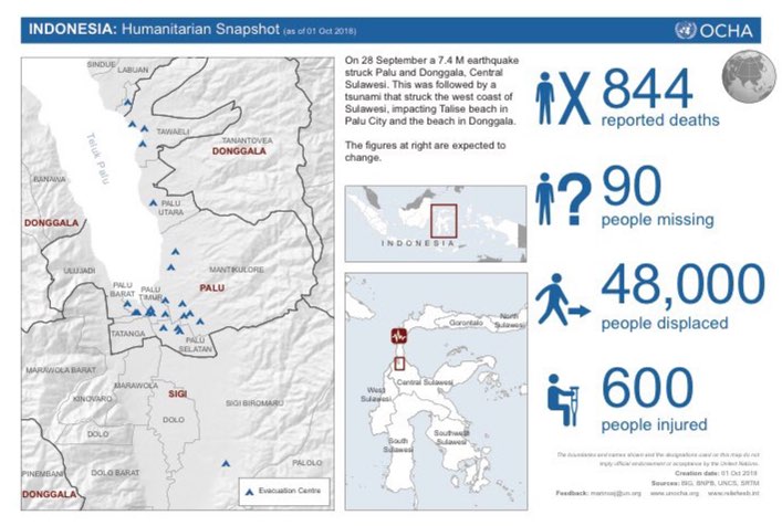
Update 15:04 UTC: a well made overview from UN OCHA
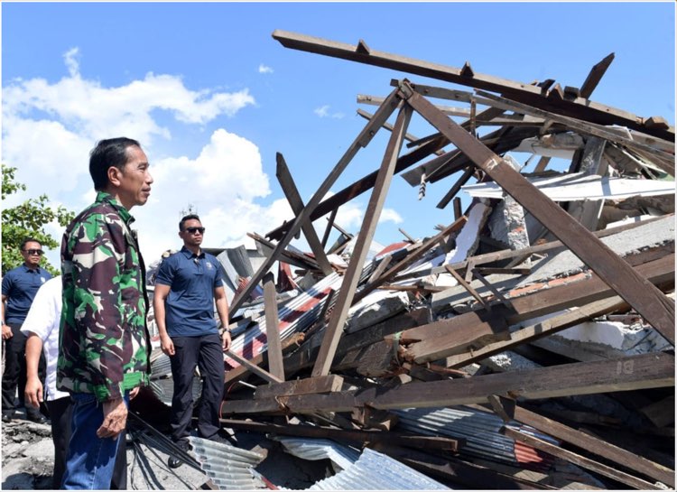
Update 14:29 UTC: Indonesian President Jokowi in front of the terrible rubble
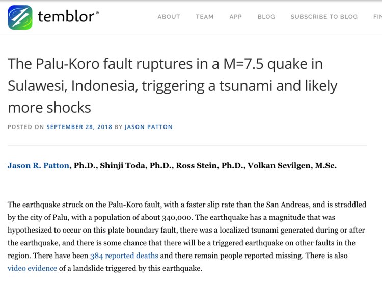
Update 21:17 UTC: Temblor article of Dr. Jay Patton for those wanting to know more of the tectonics. Click on the image to read to complete article
Update 17:58 UTC: Head of BNPB warns people NOT to believe in earthquake predictions.
Hoaxes threat of earthquake and tsunami began to spread in Palu City and other areas.
People are restless.
Please receive information like this ABAIKAN. This is HOAX. There is no country in the world and science and technology is capable of predicting earthquakes with certainty.
Hoax ancaman gempa dan tsunami mulai menyebar di Kota Palu dan daerah lain. Masyarakat resah. Mohon jika menerima informasi seperti ini ABAIKAN. Ini HOAX. Tidak ada satu pun negara di dunia dan iptek yang mampu memprediksi gempa secara pasti. pic.twitter.com/6DN0Dfc8mX
— Sutopo Purwo Nugroho (@Sutopo_PN) September 30, 2018
Update 17:07 UTC: Displacements of 6-8m !!!!!! on a NNW-SSE east dipping sinistral fault.
Palu fault segment co-seismic rupture through Palo city, #Sulawesi, Indonesia, Sep 28 M7.5 #earthquake. Displacements of 6-8m on a NNW-SSE east dipping sinistral fault. Strike-slip ruptures continue south in Palu valley for kms. Optical correlation w/MicMac & @planetlabs imagery. pic.twitter.com/wd6f9Z0UYN
— Sotiris Valkaniotis (@SotisValkan) September 30, 2018
Update 08:00 UTC: On this video you can see the first tsunami wave and swell entering the beach communities. People are not aware of the tsunami and only evacuate after screaming from other people who see arriving the tsunami in the distance.
Masih banyak masyarakat yang berada di pantai saat tsunami sebelum menerjang Pantai Kota Palu (28/9/2018). Tidak ada sirine berbunyi. Masyarakat banyak yang tidak tahu ancamannya sehingga masih melakukan aktivitas di pantai. Akhirnya banyak korban akibat tsunami. #palutsunami pic.twitter.com/hwxw29UlBR
— Sutopo Purwo Nugroho (@Sutopo_PN) September 29, 2018
Update 07:56 UTC: At least 50 people were killed in this building alone
Evakuasi korban tertimbun gempa di Hotel Roa-Roa Kota Pqluterus dilakukan Tim SAR Gabungan dikoordinir Basarnas. Diperkiran terdapat 50 orang di bawah reruntuhan bangunan. Alat berat diperlukan untuk evakuasi. pic.twitter.com/LGWwp3OEhE
— Sutopo Purwo Nugroho (@Sutopo_PN) September 30, 2018
Update 07:51 UTC: Disaster agency spokesman Sutopo Purwo Nugroho told a news conference Sunday that the death toll had more than doubled to 832, with nearly all of those killed in Palu. He said there were still not comprehensive reports about casualties in surrounding coastal areas.
Update 17:46 UTC: Seismologists are still searching for the origin of the tsunami. Many specialists are currently analysing data like Dr. Jay Patton is mentioning below.
vertical motion. looking forward to inSAR analyses. lateral spread or vert motion from eq?
given strikeslip, people incl me have hypothesized tsunami was landslide triggered. however, waves observed 300km south at Mumuju
more work needs to be conducted to inform us with facts https://t.co/GocUegViJi
— patton_cascadia (@patton_cascadia) September 29, 2018
Update 15:01 UTC: Pictures we know from other tsunami stricken coasts like Japan, Chile and Indonesia
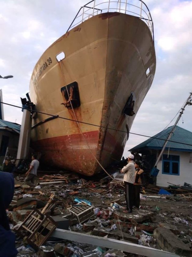
Update 14:59 UTC: Aerial pictures of Indonesia's Civil service BNPB of the tsunami devastation in Palu, Sulawesi
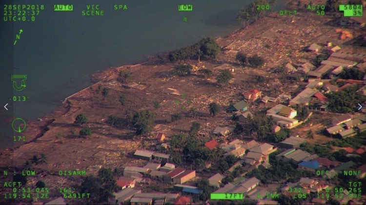
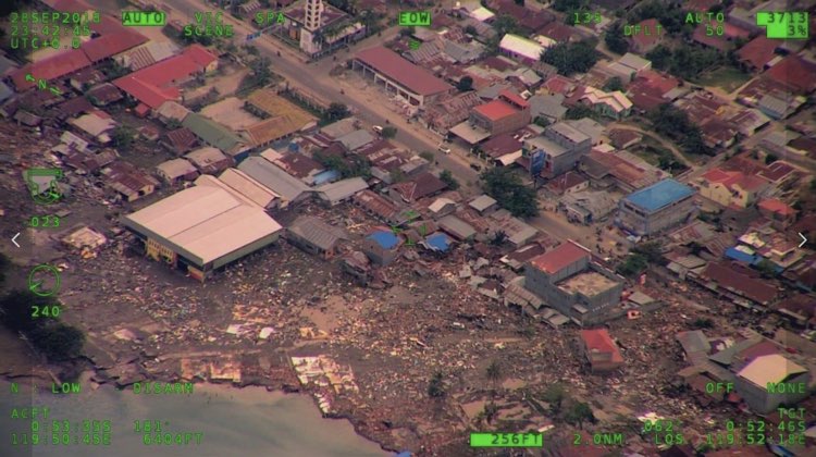
Update 13:38 UTC: A lot of people are still unaccounted for as it is feared that they have been washed out in the sea. We at ER fear that the final toll may even reach approx. 1000 as in similar earlier earthquakes the early toll had to be multiplied by 2.5 to 4. Lets hope that we are wrong.
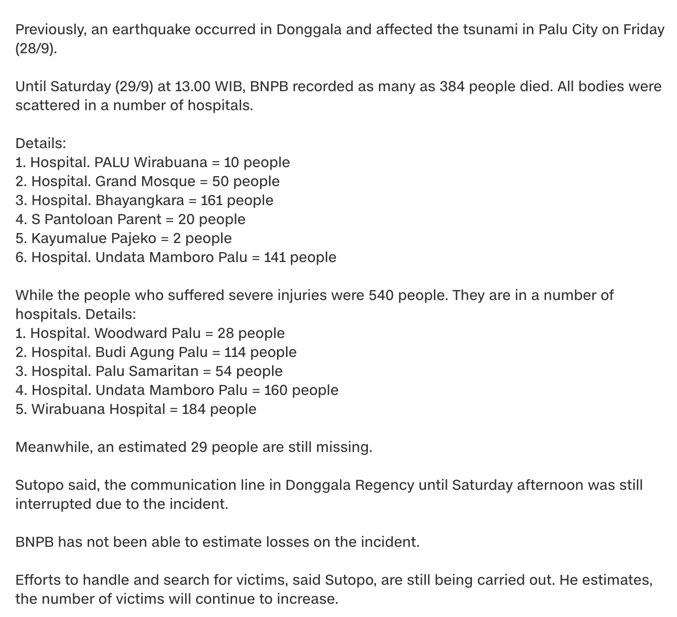
BREAKING Update 09:21 UTC: The death toll may rise a lot higher as the fate of tens or even hundreds of people present at the Palu Beach Festival is still unknown. Only 4 corpses were found. As the tsunami, who was triggered almost on the coast itself, might have struck after only a couple of minutes many people may have been pulled into the sea :((((((
Update 09:03 UTC: The death toll is NOT the final toll as at least 21 persons are still missing. Almost all of the death persons are tsunami victims.
Update 08:12 UTC: Dr. Jay Patton wrotre in his report :
Using empirical relations for historic earthquakes compiled by Wells and Coppersmith (1994), Socquet et al. (2016) suggest that the Palu-Koro fault system could produce a magnitude M 7 earthquake once per century. However, studies of prehistoric earthquakes along this fault system suggest that, over the past 2000 years, this fault produces a magnitude M 7-8 earthquake every 700 years (Bellier et al., 2006). So, it appears that this is the characteristic earthquake we might expect along this fault.
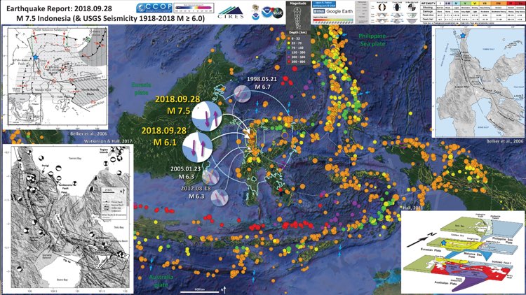
Update 08:03 UTC: The ultimate explanatory earthquake poster from this earthquake comes from geologist Dr. Jay Patton. Click on the image to be linked to his site. The poster contains lots of important scientific information and can be viewed in full format in his site. Dr Jay Patton is gifted with the ability to translate hard to understand scientific material into easy, everyday language (through texts and images).
Update 08:03 UTC:
After looking at this event this morning this looks like a landslide tsunami (either on land or beneath the surface). Tsunami warning technologies are not well equipped for landslides and this event likely highlights a need for new work on landslide generated tsunamis. #tsunami https://t.co/opveNyGXNk
— Switzer Coastal lab (@CoastalLabNTU) September 29, 2018
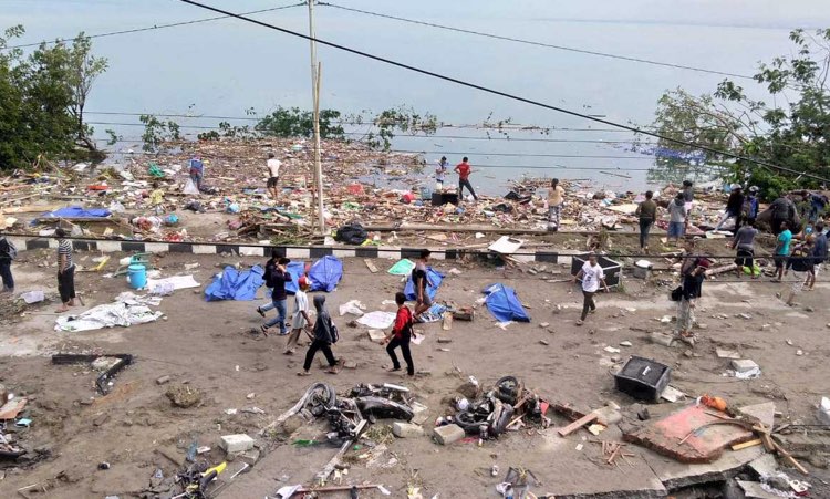
Update 08:08 UTC: A small part of the tsunami beach showing the rubble after the devastating flood + bodies covered with blue sheets
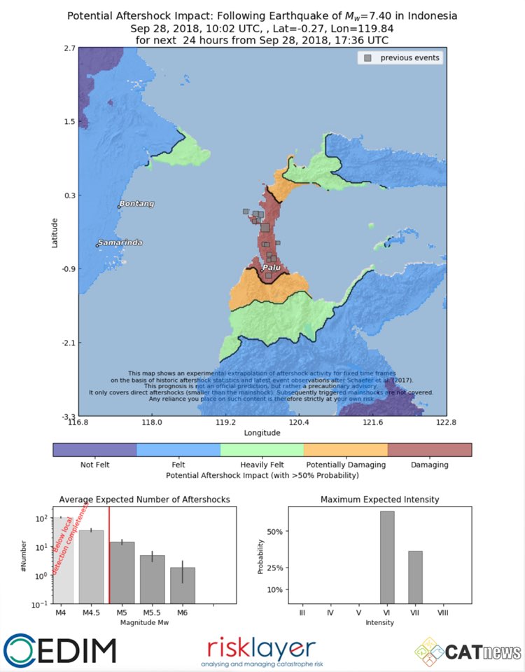
Update 07:57 UTC: Potential aftershock impact as modelled by Andreas Schäfer, Cedim, Catnews, Karsruhe, Germany
Aftershochs up to M5+ are still hammering the region
 Important update : Death toll caused by the earthquake and ensuing tsunami in Indonesia has jumped to 384, authorities said
Update : Pictures of the devastating local landslide underwater tsunami which happened at relatively far from the epicenter. Earthquake specialists did know the risk for underwater landslides as it happened before. The destruction reminds us of the Banda Aceh tsunami in 2004.


Update 07:39 UTC: Strange situation yesterday as the epicenter was below land and could eventually generate limited water swells and/or a minor tsunami up to 1 meter but not de destruction we have seen on the video's. Below a translated tweet mentioning an underwater landslide as the main reason.
Analysis of tsunami experts while dsri ITB based on modeling studies and before that a tsunami in the hammer caused by underwater avalanches during the 7.7 SR rocked the Donggala. Gulf coastal Donggala and Palu is indeed prone to tsunamis. Still do the study again.
Analisis sementara ahli tsunami dsri ITB berdasarkan modeling dan kajian sebelumnya bahwa tsunami di Palu disebabkan adanya longsoran bawah laut saat gempa 7,7 SR mengguncang Donggala. Teluk Palu dan pesisir Donggala memang rawan tsunami. Masih dilakukan kajian lagi. pic.twitter.com/1YbHEFmTfT
— Sutopo Purwo Nugroho (@Sutopo_PN) September 29, 2018
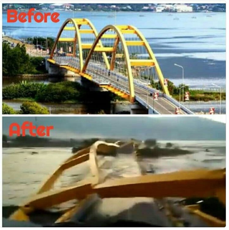
Update 23:44 UTC: a bridge in Palu before and after the earthquake. It was flooded after the tsunami
Update 23:39 UTC: VIDEO - Tsunami waves of 3 meter crashed into a village destroying everything on its path. People were alerted by a tsunami akarlm that a tsunami might be coming. So far no indication of victims from the tsunami but for sure if people were caught into it they would not survive. Other reports are speaking of tsunami's of 6 meter.
Detik-detik saat tsunami menerjang Pantai Palu pada 28/9/2018 sore pascagempa 7,7 SR mengguncang Donggala. Tinggi tsunami sekitar 3 meter. Permukiman di sekitar pantai hancur disapu tsunami. pic.twitter.com/GnxecozDKk
— Sutopo Purwo Nugroho (@Sutopo_PN) September 28, 2018
Update 21:15 UTC: Latest number of fatalities is 7
IMPORTANT Update 15:52 UTC: sad to tell our readers that at least 6 people have been killed due to this earthquake
Update 12:52 UTC: Hard to check whether this was today's tsunami but based on other data it could be indeed the case
https://twitter.com/CholinsM/status/1045657042852098049
Update 12:45 UTC: Misery misery misery ... One house on this video has apparently collapsed.
Rumah dan bangunan banyak yang mengalami kerusakan akibat gempa 7,7 SR di Kota Palu dan Donggala Sulawesi Tengah. Berdasarkan analisis gempa dirasakan intensitas gempa VI-VII MMI (keras hingga sangat keras). Biasanya bangunan banyak yang roboh. Evakuasi masih dilakukan. pic.twitter.com/7yCf2sMAwL
— Sutopo Purwo Nugroho (@Sutopo_PN) September 28, 2018
Update 11:16 UTC: Sad to report that the earlier M6 earthquake did kill 1 person and injured 10 others. At least 1 house was destroyed. No numbers yet of the M7.5 earthquake
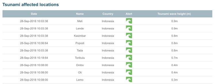
Update 11:00 UTC: Tsunami waves and surge are expected to be max. 0.9 meter
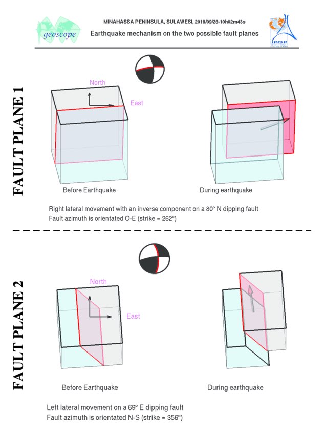
Update 10:56 UTC: the focal mechanism of this earthquake reflects the worst type, a strike slip mechanism
Update 10:55 UTC: Main earth movement based on the current focal mechanism.
People who experienced the shaking can easily determine which of both fault planes is the right one.
Images courtesy Observatoire Geoscope
Update 10:54 UTC: a whole series of moderate to strong aftershocks are hammering the epicenter region
Update 10:53 UTC: First video of people running outside their houses and praying to their God
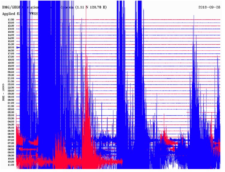
Update 10:47 UTC: Seismogram as recorded in a seismological station in Sulawesi
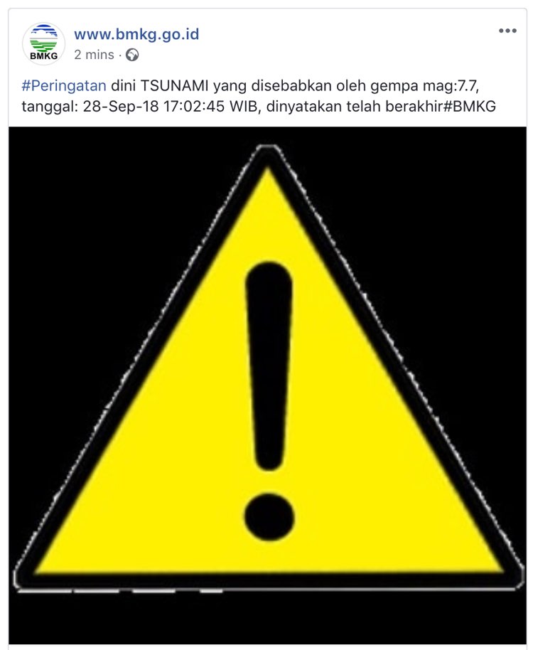
Update 10:41 UTC: A local TSUNAMI alert has been called in Indonesia. NO alert for the pacific
Update 10:30 UTC: Luckily the earthquake happened during the day which means that many people were out of their houses. Before this massive earthquake, another very strong earthquake occurred in the same region which may had already an effect that people were hiding outside of their houses out of fear for aftershocks.
Update 10:27 UTC: Shaking impact on nearby cities and villages and on the population in MMI (Modified Mercalli scaled).
20,000 people may have experienced the dangerous severe shaking.
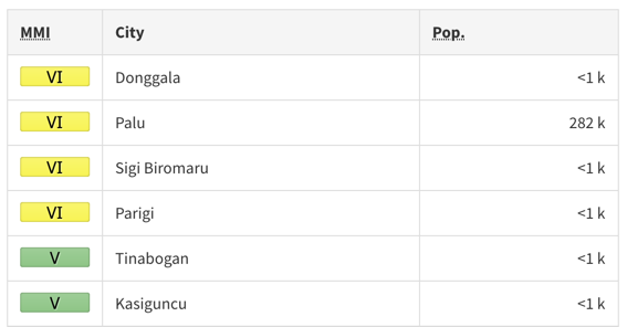
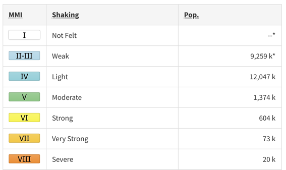
Update 10:26 UTC: USGS shaking map
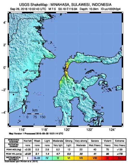
Update 10:25 UTC: Severe shaking MMI VIII must have been experienced following USGS

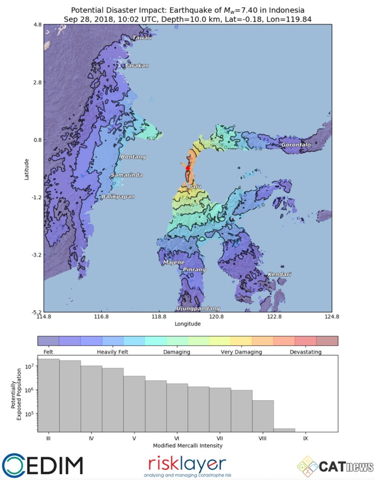
Update 10:20 UTC: Shaking map with possible related damage from the natural disaster specialists at CATnews (Risklayer - CEDIM), Karlsruhe, Germany. Map generated by Andreas Schäfer.
Update 10:14 UTC: More in a moment ... collecting more information but it looks very grimm to me
Update 10:13 UTC: Based on the present earthquake parameters (Magnitude, Depth, Population, etc) and our experience with earthquake damage impact, earthquake-report.com calls this earthquake extremely dangerous and expects injuries and serious damage

Map courtesy Alomax.free.net - Star: calculated epicenter - Small red dots: possible error margin for the epicenter, the more dense, the higher probability that the epicenter will be in that area. Orange circle: epicenter location error zone
Most important Earthquake Data:
Magnitude : 7.5
Local Time (conversion only below land) : Unknown
GMT/UTC Time : 2018-09-28 10:02:44
Depth (Hypocenter) : 10 km
Depth and Magnitude updates in the list below.
Share your earthquake experience (I Have Felt It) with our readers.
Click on the "I Felt It" button behind the corresponding earthquake. Your earthquake experience is not only important for science, but also for people in the area as well as our global readership.

| Refresh this list | ||||||
| SRC | Location | UTC Date/time | M | D | INFO | |
| EMSC | Sulawesi, Indonesia | Sep 28 21:24 | 5.0 | 20 | MAP I Felt It INFO | |
|
|
||||||
| GEOFON | Sulawesi, Indonesia | Sep 28 21:24 | 4.9 | 10 | MAP | |
| USGS | Kasiguncu, Indonesia | Sep 28 20:34 | 4.4 | 10 | MAP I Felt It INFO | |
| USGS | Kasiguncu, Indonesia | Sep 28 17:05 | 4.6 | 10 | MAP I Felt It INFO | |
| EMSC | Sulawesi, Indonesia | Sep 28 15:35 | 4.9 | 10 | MAP | |
| GEOFON | Sulawesi, Indonesia | Sep 28 15:35 | 4.9 | 10 | MAP | |
| USGS | Palu, Indonesia | Sep 28 15:35 | 5.0 | 10 | MAP I Felt It INFO | |
| USGS | Palu, Indonesia | Sep 28 15:28 | 4.9 | 10 | MAP | |
| GEOFON | Minahassa Peninsula, Sulawesi | Sep 28 15:28 | 5.1 | 10 | MAP | |
| EMSC | Minahasa, Sulawesi, Indonesia | Sep 28 15:28 | 5.1 | 10 | MAP I Felt It INFO | |
| EMSC | Minahasa, Sulawesi, Indonesia | Sep 28 14:26 | 5.2 | 40 | MAP I Felt It INFO | |
| USGS | Palu, Indonesia | Sep 28 14:26 | 5.2 | 10 | MAP | |
| GEOFON | Minahassa Peninsula, Sulawesi | Sep 28 14:26 | 5.4 | 30 | MAP | |
| USGS | Palu, Indonesia | Sep 28 14:10 | 4.7 | 10 | MAP | |
| GEOFON | Minahassa Peninsula, Sulawesi | Sep 28 14:10 | 4.8 | 10 | MAP I Felt It INFO | |
| USGS | Palu, Indonesia | Sep 28 13:39 | 5.2 | 10 | MAP I Felt It INFO | |
| USGS | Palu, Indonesia | Sep 28 13:35 | 5.7 | 10 | MAP | |
| GEOFON | Minahassa Peninsula, Sulawesi | Sep 28 13:35 | 5.6 | 10 | MAP | |
| GEOFON | Minahassa Peninsula, Sulawesi | Sep 28 13:10 | 4.7 | 10 | MAP | |
| USGS | Palu, Indonesia | Sep 28 13:10 | 4.8 | 10 | MAP I Felt It INFO | |
|
|
||||||
| USGS | Palu, Indonesia | Sep 28 12:39 | 4.7 | 10 | MAP | |
| USGS | Palu, Indonesia | Sep 28 12:27 | 5.1 | 10 | MAP | |
| GEOFON | Minahassa Peninsula, Sulawesi | Sep 28 12:27 | 5.5 | 10 | MAP | |
| EMSC | Minahasa, Sulawesi, Indonesia | Sep 28 12:27 | 5.1 | 40 | MAP I Felt It INFO | |
| USGS | Palu, Indonesia | Sep 28 12:05 | 4.7 | 10 | MAP | |
| GEOFON | Sulawesi, Indonesia | Sep 28 11:06 | 5.1 | 10 | MAP | |
| EMSC | Sulawesi, Indonesia | Sep 28 11:06 | 5.2 | 36 | MAP | |
| USGS | Palu, Indonesia | Sep 28 11:06 | 5.2 | 10 | MAP | |
| EMSC | Minahasa, Sulawesi, Indonesia | Sep 28 10:50 | 5.1 | 40 | MAP | |
| GEOFON | Minahassa Peninsula, Sulawesi | Sep 28 10:50 | 5.7 | 10 | MAP | |
| USGS | Palu, Indonesia | Sep 28 10:50 | 5.7 | 10 | MAP I Felt It INFO | |
| EMSC | Minahasa, Sulawesi, Indonesia | Sep 28 10:47 | 5.1 | 30 | MAP | |
| USGS | Palu, Indonesia | Sep 28 10:47 | 5.1 | 10 | MAP | |
| GEOFON | Minahassa Peninsula, Sulawesi | Sep 28 10:47 | 5.0 | 10 | MAP | |
| EMSC | Minahasa, Sulawesi, Indonesia | Sep 28 10:39 | 5.4 | 65 | MAP | |
| GEOFON | Minahassa Peninsula, Sulawesi | Sep 28 10:39 | 5.4 | 10 | MAP | |
| USGS | Palu, Indonesia | Sep 28 10:39 | 5.4 | 10 | MAP | |
| GEOFON | Minahassa Peninsula, Sulawesi | Sep 28 10:25 | 5.7 | 10 | MAP | |
| USGS | Palu, Indonesia | Sep 28 10:25 | 5.8 | 10 | MAP | |
| USGS | Palu, Indonesia | Sep 28 10:16 | 5.7 | 10 | MAP | |
| GEOFON | Minahassa Peninsula, Sulawesi | Sep 28 10:16 | 5.7 | 10 | MAP | |
| USGS | Palu, Indonesia | Sep 28 10:14 | 5.8 | 10 | MAP | |
| GEOFON | Minahassa Peninsula, Sulawesi | Sep 28 10:14 | 5.8 | 10 | MAP | |
| GEOFON | Minahassa Peninsula, Sulawesi | Sep 28 10:02 | 7.5 | 10 | MAP I Felt It INFO | |
| USGS | Palu, Indonesia | Sep 28 10:02 | 7.5 | 10 | MAP | |
| USGS | Palu, Indonesia | Sep 28 09:57 | 4.8 | 10 | MAP | |
| EMSC | Minahasa, Sulawesi, Indonesia | Sep 28 08:24 | 5.0 | 30 | MAP | |
| GEOFON | Minahassa Peninsula, Sulawesi | Sep 28 08:24 | 5.0 | 10 | MAP I Felt It INFO | |
|
|
||||||
| USGS | Palu, Indonesia | Sep 28 08:24 | 5.0 | 10 | MAP | |
| GEOFON | Minahassa Peninsula, Sulawesi | Sep 28 07:28 | 5.0 | 10 | MAP | |
| USGS | Palu, Indonesia | Sep 28 07:28 | 4.9 | 10 | MAP | |
| USGS | Palu, Indonesia | Sep 28 07:03 | 5.4 | 10 | MAP | |
| GEOFON | Minahassa Peninsula, Sulawesi | Sep 28 07:03 | 5.3 | 10 | MAP I Felt It INFO | |
| USGS | Palu, Indonesia | Sep 28 07:00 | 6.1 | 18 | MAP | |
| GEOFON | Minahassa Peninsula, Sulawesi | Sep 28 07:00 | 6.0 | 10 | MAP I Felt It INFO | |
|
|
||||||
FOLLOW earthquake-report.com on TWITTER : @Quake_tracker4
Other earthquakes in the greater epicenter area
Strongest earthquakes (since 1900) within a 150 km radius from this earthquake


