Have you felt the shaking? If Yes, tell us by using the I FELT IT form behind the earthquake or at the bottom of this page.
Using our EQ Report iOS or Android app would even be easier and very informative (links in banner above this text).
Read also our report of the M6.3 aftershock earlier today in the same area of Lombok.
–
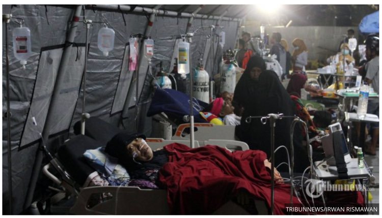
Update 13:21 UTC: The death toll has now risen to 14 and is expected to continue to rise as communications are still cut to most of NE and E Lombok. 151 houses, 6 facilities and one office also damaged. However, the damages will undoubtedly rise as the areas cut off from communicating are able to do so.
Update 07:33 UTC: Intermediate damage UPDATE: at least
* 10 people killed
* 24 people injured
* 131 houses destroyed
The reason that this severe shaking earthquake did not make more suffering and damage is that most of the people stayd outside in the open air because of the fear for aftershocks after the M6.3 earthquake hours earlier.
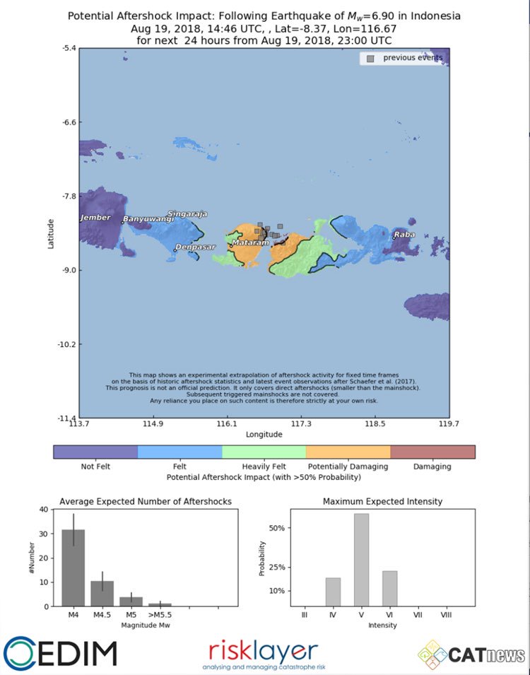
Important Update 07:26 UTC: ER: CATnews tries to put the scientific approach towards aftershocks after major earthquakes 1 step further.This is NOT to be seen as a earthquake prediction, but a rather an advisory of potentially upcoming direct aftershocks based on a scientific approach utilizing historic and concurrent mainshock-aftershock patterns. Subsequent mainshocks (e.g. the two M6.9 Lombok earthquakes or the sequence around Christchurch in 2010-2011) are not part of this advisory.
Catnews : with the on-going aftershocks, earthquakes around Lombok, Bali and Sumbawa, here is an experimental (direct) aftershock prognosis map
It is hoped this map can support disaster relief and personal welfare.
Update 22:44 UTC: A video from a hotel in Bali where all the tourists did evacuate for the open space.
Wisatawan asing di Bali segera keluar dari bangunan merasakan guncangan gempa 7 SR di Lombok Timur pada 19/8/2018 pukul 21.56 WIB. Gempa dirasakan keras di Lombok Timur. Gempa juga dirasakan di Bali, Sumbawa, Jawa Timur dan Makassar. Masih dilakukan pendataan dampak gempa. pic.twitter.com/2jNBkWDFUf
— Sutopo Purwo Nugroho (@Sutopo_PN) August 19, 2018
Update 22:42 UTC: also common during earthquakes : fires
Kebakaran melanda permukiman di Desa Bungin Pulau Bungin Kabupaten Sumbawa NTB. Kebakaran disebabkan adanya rumah roboh saat gempa 7 SR kemudian rumah terbakar. pic.twitter.com/gbjsgtvz6j
— Sutopo Purwo Nugroho (@Sutopo_PN) August 19, 2018
Update 22:41 UTC: serious cracks in a road
Kondisi jalan retak-retak di Pelabuhan Kayangan Lombok Utara akibat gempa 7 SR pada 19/8/2018. Kerasnya guncangan gempa menyebabkan kerusakan bangunan, longsor di perbukitan dan listrik padam. Komunikasi masih belum dapat dilakukan dengan petugas di Lombok Timur. pic.twitter.com/vO5OZyjjhG
— Sutopo Purwo Nugroho (@Sutopo_PN) August 19, 2018
Update 21:06 UTC: Again sad news : At least 2 people got killed during this earthquake.
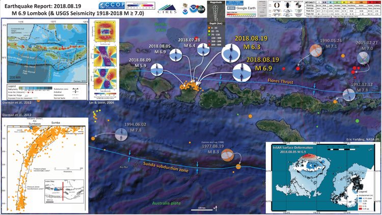
Update 21:04 UTC: The ultimate explanatory earthquake poster from this earthquake comes from geologist Dr. Jay Patton. Click on the image to be linked to his site. The poster contains lots of important scientific information and can be viewed in full format in his site. Dr Jay Patton is gifted with the ability to translate hard to understand scientific material into easy, everyday language (through texts and images).
Update 18:12 UTC: as could be expected, many many aftershocks
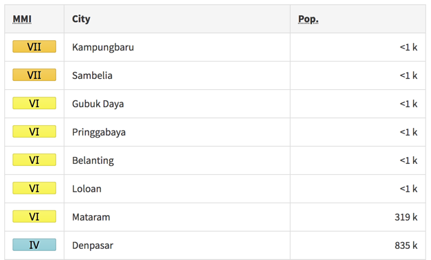
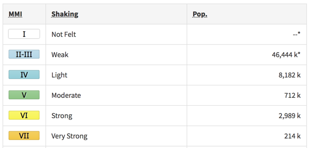
Update 17:58 UTC: Shaking impact on nearby cities and villages and on the population in MMI (Modified Mercalli scaled).
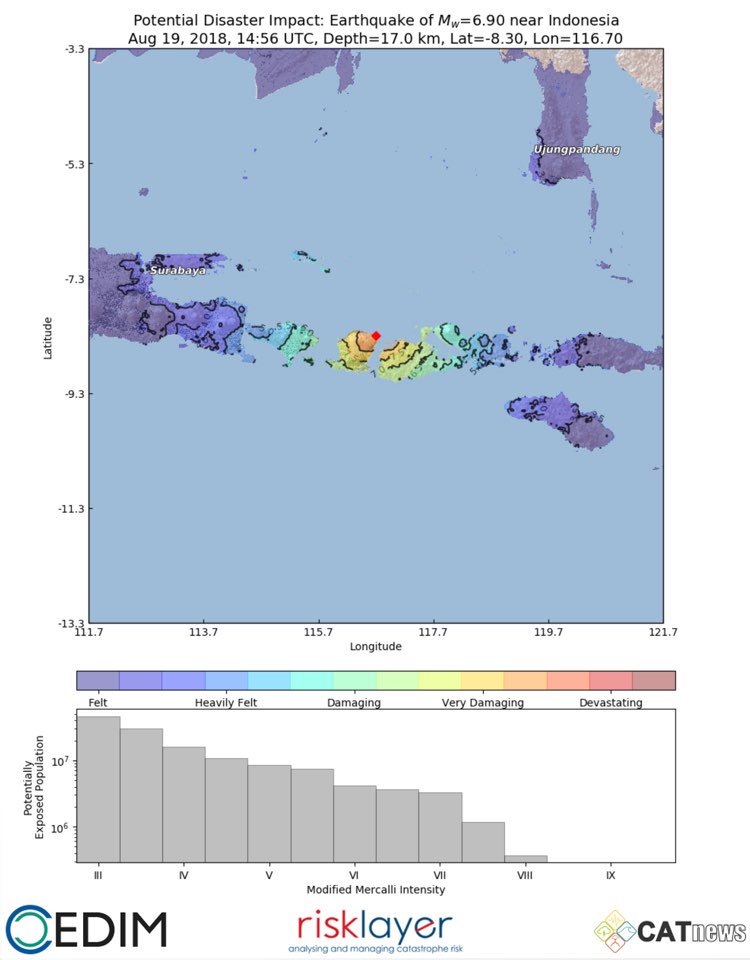
Update 17:54 UTC: Shaking map with possible related damage from the natural disaster specialists at CATnews (Risklayer - CEDIM), Karlsruhe, Germany. Map generated by Andreas Schäfer.
Major damage expected also for #Sumbawa, well felt on #Bali, but not as dangerous (compared to the last one), minor #Tsunami possible (<1m)
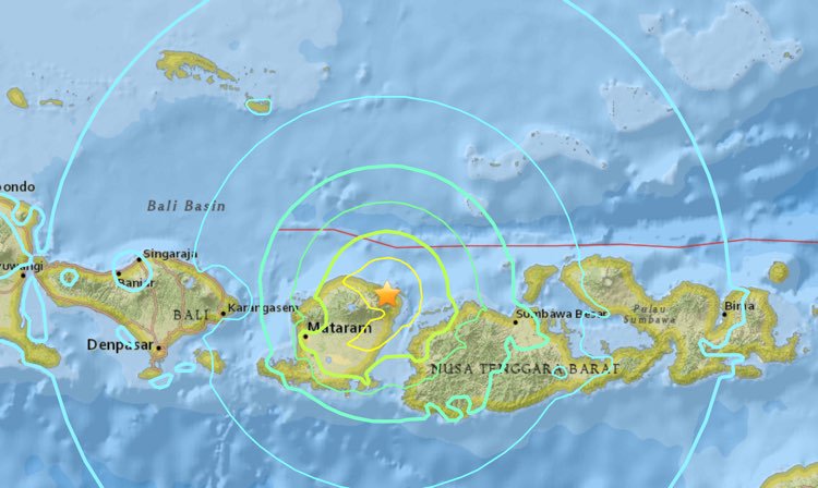
Update 17:53 UTC: Based on the present earthquake parameters (Magnitude, Depth, Population, etc) and our experience with earthquake damage impact, earthquake-report.com calls this earthquake extremely dangerous and expects injuries and serious damage
Most important Earthquake Data:
Magnitude : 6.9
Local Time (conversion only below land) : 2018-08-19 22:56:27
GMT/UTC Time : 2018-08-19 14:56:27
Depth (Hypocenter) : 21 km
Depth and Magnitude updates in the list below.
Share your earthquake experience (I Have Felt It) with our readers.
Click on the "I Felt It" button behind the corresponding earthquake. Your earthquake experience is not only important for science, but also for people in the area as well as our global readership.

| Refresh this list | ||||||
| SRC | Location | UTC Date/time | M | D | INFO | |
| GEOFON | Sumbawa Region, Indonesia | Aug 19 23:29 | 4.8 | 10 | MAP | |
| USGS | Obelobel, Indonesia | Aug 19 23:29 | 4.6 | 10 | MAP I Felt It INFO | |
|
|
||||||
| EMSC | Lombok Region, Indonesia | Aug 19 23:29 | 4.6 | 14 | MAP | |
| USGS | Sambelia, Indonesia | Aug 19 21:50 | 5.1 | 10 | MAP | |
| GEOFON | Sumbawa Region, Indonesia | Aug 19 21:50 | 4.9 | 10 | MAP | |
| USGS | Sembalunlawang, Indonesia | Aug 19 21:44 | 4.7 | 10 | MAP | |
| USGS | Lekong, Indonesia | Aug 19 21:21 | 4.9 | 35 | MAP | |
| EMSC | Lombok Region, Indonesia | Aug 19 21:21 | 4.9 | 12 | MAP | |
| GEOFON | Sumbawa Region, Indonesia | Aug 19 21:21 | 4.9 | 10 | MAP I Felt It INFO | |
| EMSC | Lombok Region, Indonesia | Aug 19 18:23 | 5.2 | 40 | MAP | |
| GEOFON | Sumbawa Region, Indonesia | Aug 19 18:23 | 5.2 | 20 | MAP I Felt It INFO | |
|
|
||||||
| USGS | Labuhanmapin, Indonesia | Aug 19 18:23 | 5.2 | 10 | MAP | |
| EMSC | Lombok Region, Indonesia | Aug 19 18:18 | 4.9 | 10 | MAP | |
| GEOFON | Sumbawa Region, Indonesia | Aug 19 18:18 | 4.9 | 10 | MAP | |
| GEOFON | Sumbawa Region, Indonesia | Aug 19 17:28 | 4.8 | 10 | MAP | |
| EMSC | Lombok Region, Indonesia | Aug 19 17:28 | 4.8 | 10 | MAP I Felt It INFO | |
| EMSC | Lombok Region, Indonesia | Aug 19 16:37 | 5.3 | 30 | MAP | |
| GEOFON | Sumbawa Region, Indonesia | Aug 19 16:37 | 5.3 | 14 | MAP | |
| USGS | Labuhanmapin, Indonesia | Aug 19 16:37 | 5.3 | 10 | MAP | |
| EMSC | Lombok Region, Indonesia | Aug 19 16:21 | 5.0 | 30 | MAP | |
| GEOFON | Sumbawa Region, Indonesia | Aug 19 16:21 | 5.0 | 15 | MAP I Felt It INFO | |
| USGS | Labuhanmapin, Indonesia | Aug 19 16:21 | 5.0 | 10 | MAP | |
| GEOFON | Sumbawa Region, Indonesia | Aug 19 15:45 | 5.0 | 10 | MAP | |
| USGS | Sambelia, Indonesia | Aug 19 15:45 | 4.8 | 10 | MAP | |
| EMSC | Lombok Region, Indonesia | Aug 19 15:45 | 4.8 | 10 | MAP | |
| EMSC | Lombok Region, Indonesia | Aug 19 15:29 | 5.4 | 10 | MAP | |
| GEOFON | Sumbawa Region, Indonesia | Aug 19 15:29 | 5.5 | 24 | MAP | |
| USGS | Sembalunbumbung, Indonesia | Aug 19 15:28 | 5.5 | 10 | MAP | |
| USGS | Kampungbaru, Indonesia | Aug 19 15:16 | 5.9 | 10 | MAP | |
| GEOFON | Sumbawa Region, Indonesia | Aug 19 15:16 | 5.7 | 51 | MAP | |
| USGS | Belanting, Indonesia | Aug 19 14:56 | 6.9 | 25 | MAP | |
| GEOFON | Sumbawa Region, Indonesia | Aug 19 14:56 | 6.9 | 21 | MAP I Felt It INFO | |
|
|
||||||
| USGS | Belanting, Indonesia | Aug 19 10:42 | 4.6 | 19 | MAP | |
| EMSC | Lombok Region, Indonesia | Aug 19 10:42 | 4.6 | 15 | MAP I Felt It INFO | |
| GEOFON | Sumbawa Region, Indonesia | Aug 19 10:42 | 4.9 | 10 | MAP I Felt It INFO | |
| USGS | Sambelia, Indonesia | Aug 19 09:50 | 4.7 | 35 | MAP | |
| EMSC | Lombok Region, Indonesia | Aug 19 09:50 | 4.7 | 10 | MAP | |
| GEOFON | Sumbawa Region, Indonesia | Aug 19 09:50 | 5.0 | 10 | MAP I Felt It INFO | |
| GEOFON | Sumbawa Region, Indonesia | Aug 19 04:10 | 6.3 | 20 | MAP | |
| USGS | Sembalunlawang, Indonesia | Aug 19 04:10 | 6.3 | 7 | MAP | |
| USGS | Sembalunbumbung, Indonesia | Aug 19 04:06 | 5.4 | 10 | MAP | |
| EMSC | Lombok Region, Indonesia | Aug 19 04:06 | 5.4 | 12 | MAP | |
| GEOFON | Sumbawa Region, Indonesia | Aug 19 04:06 | 5.5 | 14 | MAP I Felt It INFO | |
|
|
||||||
FOLLOW earthquake-report.com on TWITTER : @Quake_tracker4
Other earthquakes in the greater epicenter area
Strongest earthquakes (since 1900) within a 150 km radius from this earthquake


