 Click here to read the latest part of our report
This report is compiled out of many information sources.
For our El Hierro volcano report : Click here
Shiveluch, Kamchatka - January 15, 23:55 UTC (Janine)
KVERT has released a volcano observatory notice for aviation, reporting an explosive eruption that produced an ash column reaching 9,000-10,o00 m (29,520-32,800 ft) above seal level. The plume has traveled 63 km to the west of the volcano.
Pacaya, Guatemala - January 15, 12:15 UTC (Janine)
INSIVUMEH has released a special bulletin describing an increase in activity. In the past few days 24 ash explosions have occurred, accompanied by LP (low-frequency) seismic activity, and volcanic tremor associated with magma degassing and/or ascent. Field observations report an increase in temperatures near the MacKenny and Cerro Chino craters that has affected vegetation. Civil aviation is advised to take precaution as fine ash is likely to disperse 5 km south west of the volcano.
Hunga Tonga-Hunga Ha'apai, Tonga - January 15, 11:20 UTC (Janine)
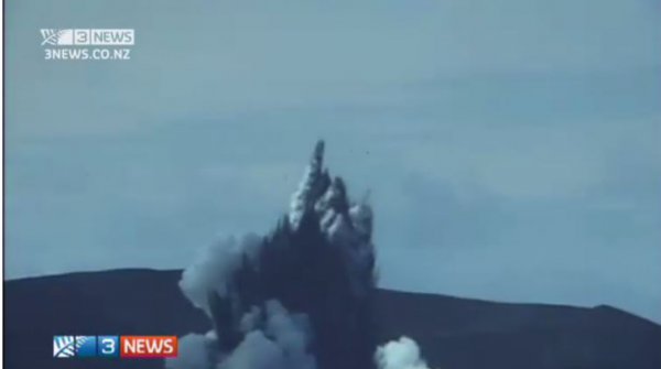
Tongan geologists have managed to get a boat near the erupting volcano. The video below shows the classic cock's tail jets and base surge from the interaction with water. Geologists struggled to get closer with the danger from the eruption and also experienced acid rain.
To see video click here
Klyuchevskoy, Kamchatka - January 15, 11:05 UTC (Janine)
KVERT has issued an observatory notice for aviation due to the explosive continuation of the eruption that began on 1 January. The eruption is characterized by strombolian and vulcanian activity, sending ash 5-6 km above sea level. The eruption has the potential to produce ash plumes that reach 8-10 km above sea level any time.
Fuego, Guatemala - January 14, 22:30 UTC (Janine)
INSIVUMEH has released a special bulletin reporting the increase in activity at Fuego. There are currently 4-6 explosions per hour producing shock waves and ejecting ash plumes to 5000 m (16, 404 ft.), predominately traveling 15 km westward. Avalanches are descending down the cone resulting in vegetation fires. This activity is likely to generate lava flows and/or pyroclastic flows. The below video was published on 3 January (no date of eruption included).
Nevado del Ruiz, Colombia - January 14, 15:25 UTC (Janine)
Servicio Geológico Colombiano’s (SGC) Observatorio Vulcanológico and Sismológico de Manizales reports the continuation of significant seismic activity associated with gas and ash emission. VT seismic activity related to rock fracturing is also occurring inside the volcano, mainly in the northeast, southwest, and around the eastern Arenas crater, at depths between 1.03 and 6.70 km. Deformation of the edifice continues.
Cerro Machin, Colombia - January 14, 15:15 UTC (Janine)
Servicio Geológico Colombiano’s (SGC) Observatorio Vulcanológico and Sismológico de Manizales has reported a change in volcanic activity, with VT earthquakes (associated with rock fracturing) located to the southeast of the lava dome, and around the dome itself. The seismic activity is mainly occurring between depths of 1.63 and 7.73 km . No other changes in activity have been reported.
Fuego, Guatemala - January 14, 14:50 UTC (Janine)
Vulcanian activity continues at Fuego, with INSIVUMEH reporting explosions producing ash plumes reaching an average of 4,600 to 4,700 m (15,091 to 15, 419 ft) and dispersing 11 to 12 km to the east and southeast. Weak avalanches continue.
Fuego, Guatemala - January 14, 02:25 UTC (Janine)
Video showing a vulcanian eruption at Fuego volcano on 11 January.
Kilauea, Hawaii - January 13, 12:30 UTC (Janine)
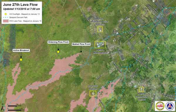
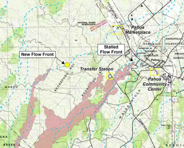
No new movement on the current lava flow front that is situated 800 m (half a mile) from Highway 130. Activity on the surface and widening of the flow continues 275 m upslope of the flow front. Two slowly advancing breakouts continue 1.6 -2.4 km (1-1.5 miles) behind the flow front.
Shiveluch, Kamchatka - January 13, 21:30 UTC (Janine)
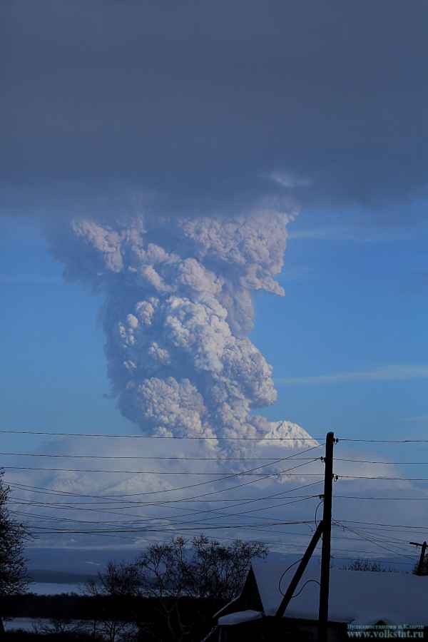
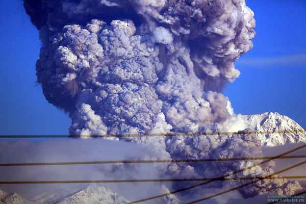
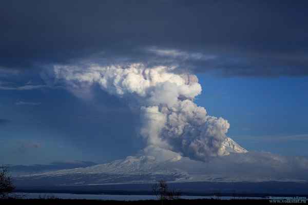
KVERT reports an elevated thermal anomaly and continued lava dome growth, the usual activity for Shiveluch. Below are images taken of the eruption earlier this week, courtesy of volkstat.ru.
Klyuchevskoy, Kamchatka - January 13 15:15 (Janine)
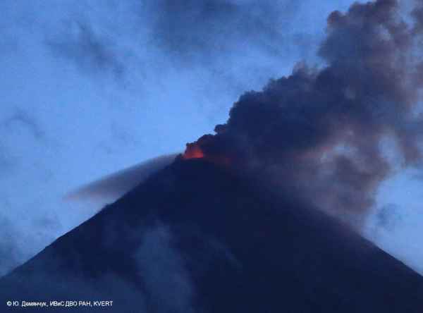
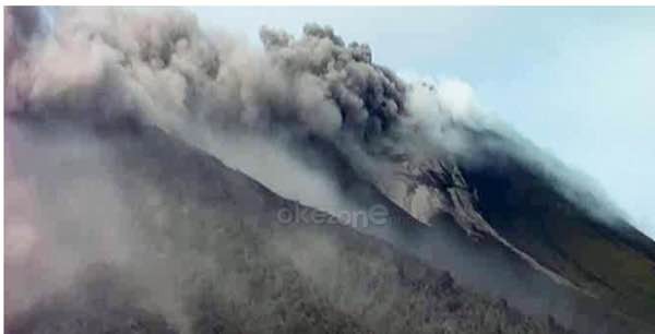
KVERT report an ongoing strombolian (shown in image below) and vulcanian eruption producing incandescence of the summit dome and hot avalanches down the slopes. Satellite data shows ash plumes rising to 6-7 km above sea level. A lava flow is currently moving down the south-eastern flank.
Fuego, Guatemala - January 12, 17:40 UTC (Janine)
INSIVUMEH reports high energy levels and number of moderate to strong explosions ejecting ash plumes to 4500-5000 m (15,419 - 16,404 ft) traveling 15 km from the vent. Explosions are generating avalanches and earthquakes that are felt 12 km from the volcano. Nearby villages are experiencing fine ashfall and an aviation warning has been given due to wind dispersion of ash.
Fuego, Guatemala - January 12, 15:00 UTC (Janine)
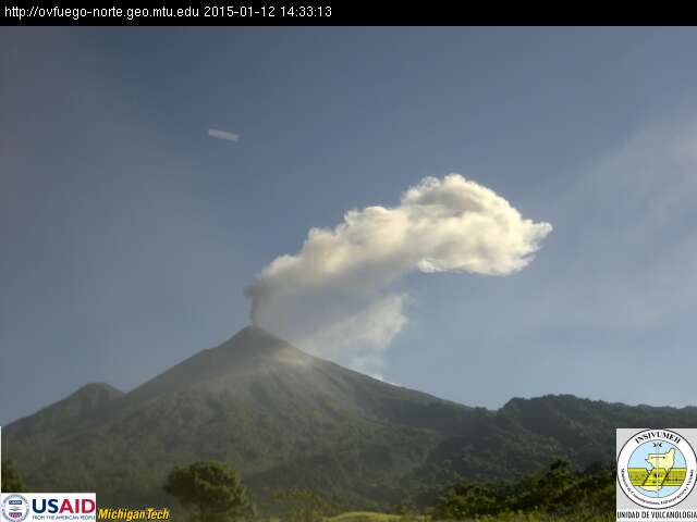
CONRED has reported weak to moderate explosions today. A recent webcam image shows a plume rising from the summit that dissipated not long afterwards.
Hunga Tonga-Hunga Ha'apai, Tonga - January 12, 14:20 UTC (Janine)
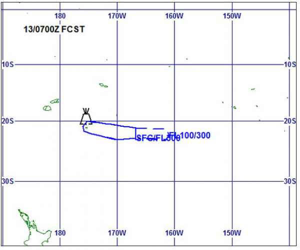
The New Zealand authorities have issued an alert to aviation as ash emission has been reported up to 16,000 ft (4800 m). Flights around the island have been diverted and one Nadi to Tonga flight cancelled.
Bardarbunga, Iceland - January 11, 10:50 UTC (Janine)
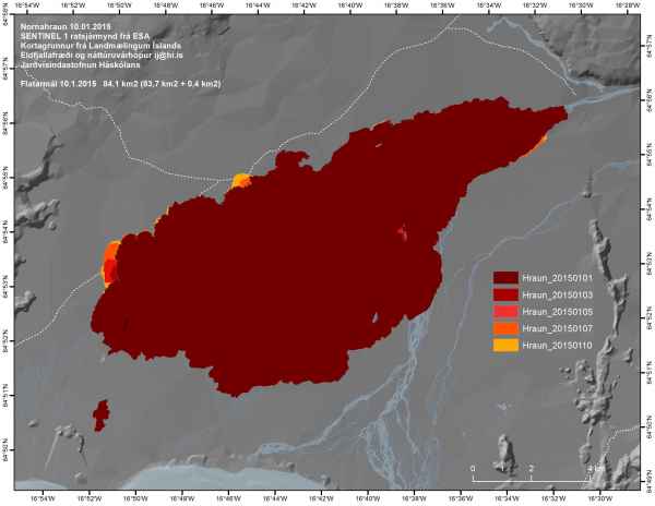
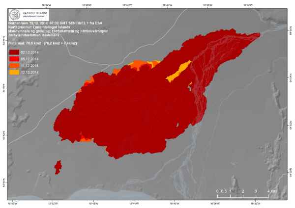
The Institute of Earth Sciences has released an updated map of the Holuhraun lava field showing the growth in the new year so far. The lava field now covers 84.1 km².
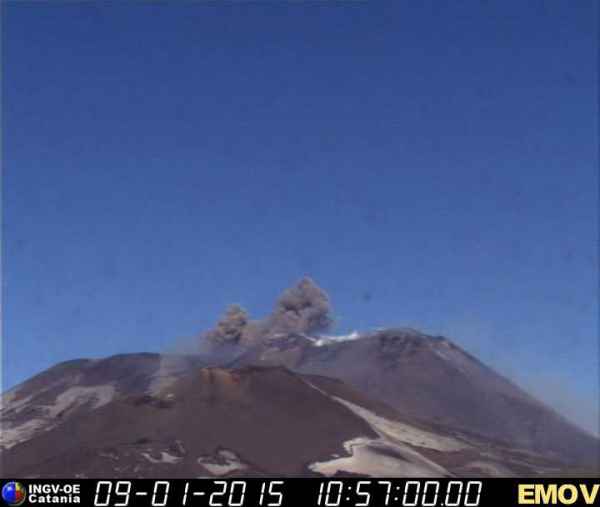
Etna, Sicily (Italy) - January 9, 11:15 UTC (Janine)
Etna is currently undergoing eruptive activity with INGV reporting explosions producing incandescent material depositing on the flanks. Small ash plumes have been generated but dissipate quickly. This activity began on January 1 with strombolian activity producing explosions every few minutes and throwing pyroclastic material up to 150 m above the crater. The current webcam image is shown below.
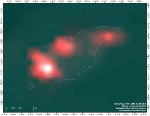
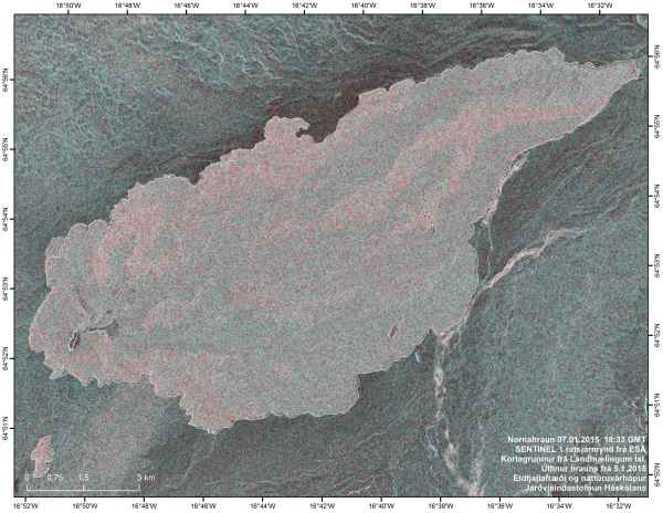
Bardarbunga, Iceland - January 9, 10:50 UTC (Janine)
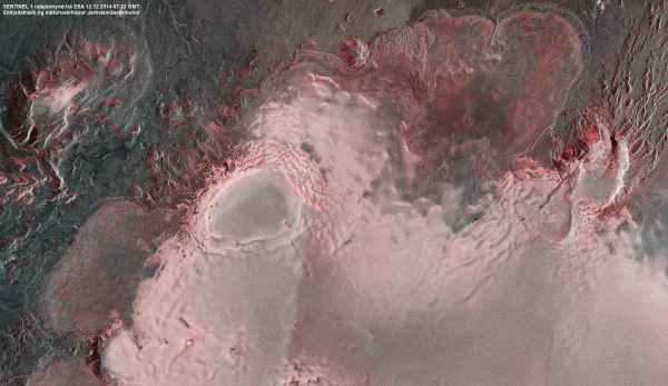
The Institute of Earth Sciences has released thermal and radar images showing the current active areas of the lava field. The radar image shows an increase in activity a the northern margin and around the north east area. The size of the lava field is now 83.8 km².
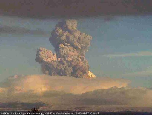
Shiveluch, Kamchatka - January 8, 16:30 UTC (Janine)
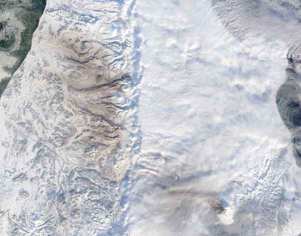
KVERT reported an eruption yesterday producing an ash plume that headed for about 350 km to the north-west. The deposit can be seen in the below Terra/MODIS satellite image acquired on January 8, courtesy of NASA Rapid Response.
Aso and Sakurajima, Japan - January 8 16:30 (Janine)
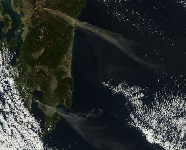
A Terra/MODIS satellite image acquired on January 7 shows Aso (north) and Sakurajima (south) volcanoes erupting, producing ash plumes simultaneously.
Message to our readers
Armand and Janine are currently in minimal mode as both are in vacation. We apologize for the minimal content during this period.
Volcano activity of the world (last 7 days) – January 8, 09:51 UTC (Armand)
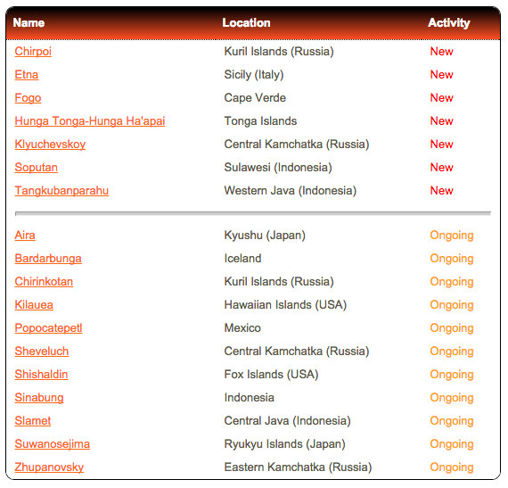
Bulletin collected and published by the Smithsonian Institute
Klyuchevskoy, Kamchatka, Russia - January 4, 23:19 UTC (Armand)
The #Strombolian activity at #Klyuchevskoy #volcano #Kamchatka Image: Volkstat.ru pic.twitter.com/AqmgQhxzwx
— Roberto C. Lopez (@Bromotengger) January 4, 2015
Colima, Mexico - January 4, 22:54 UTC (Armand)
The is the best poor video we could fins of the 3 km ash explosion on the Colima volcano in Mexico this morning
Slamet, Indonesia - January 2, 14:36 UTC (Armand)
Earlier today - Video Time Lapse (5x) in full HD Mount Etna huge volcanic ash emission from the New South East Crater (3.300m asl)
Chirpoi | Kuril Islands (Russia)
SVERT reported that satellite images over Snow, a volcano of Chirpoi, showed a thermal anomaly on 4 January. Cloud cover obscured views on other days during 30 December-5 January. The Aviation Color Code remained at Yellow.
Etna | Sicily (Italy)
INGV reported that on 29 December, a day after a short but intense eruption, cameras viewing Etna recorded small ash emissions from New Southeast Crater (NSEC) and persistent glow from the saddle between the old and new SEC cones at dusk. During the night on 1 and 2 January cameras recorded intermittent flashes from Voragine Crater (one of four summit craters), indicating Strombolian activity there for the first time in nearly two years. At 0530 on 2 January explosions at NSEC generated ash plumes that drifted SW. On the evening of 3 January explosions ejected incandescent material 150 m above the crater rim.
Fogo | Cape Verde
Based on gas-monitoring efforts of the Instituto Vulcanológico de Canárias (INVOLCAN) and data from the Toulouse VAAC, the Observatório Vulcanológico de Cabo Verde (OVCV) reported that sulfur dioxide emission rates at Fogo were 1,201-1,368 tons per day during 30-31 December and 1-2 January. A gas plume rose 700-900 m above the cone during 30-31 December and drifted N; on 31 December tephra was ejected 30-40 m away and ash was present on the plume. A lava front near S Ilhéu de Losna had been stagnant for a few days while one near the N part of the town advanced at a reduced speed, overtaking a road and parts of some housing. Temperatures of the lava fronts continued to gradually decrease. During 1-2 January a gas plume rose 400-600 m above the cone and tephra was occasionally ejected 20-25 m away.
Hunga Tonga-Hunga Ha'apai | Tonga Islands
Based on a pilot observation, the Wellington VAAC reported that an ash plume from Hunga Tonga-Hunga Ha'apai rose to an altitude of 3 km (10,000 ft) a.s.l. on 6 January.
Klyuchevskoy | Central Kamchatka (Russia)
Based on seismic data from KB GS RAS, KVERT reported that seismic activity at Klyuchevskoy began to increase during 19-20 December and then increased again on 31 December. Although cloud cover prevented views of the volcano during 31 December-1 January, a thermal anomaly was detected in satellite images on 1 January, possibly indicating that a Strombolian eruption had begun. The Aviation Color Code was raised to Yellow on 2 January.
Soputan | Sulawesi (Indonesia)
BNPB reported that an eruption at Soputan began at 1447 on 6 January. Observers at a nearby post reported a dense gray-to-black ash plume rising about 6.5 km above the summit and drifting ESE. Lava flows traveled 2 km down the WSW flank. The Alert Level remained at 3 (on a scale of 1-4). Based on ground reports from that same day, the Darwin VAAC reported that a significant eruption generated a plume that rose to an altitude of 8.2 km (27,000 ft) a.s.l. No ash was observed in satellite images due to weather clouds in the area.
Tangkubanparahu | Western Java (Indonesia)
PVMBG reported that white plumes rose at most 50 m above Tangkubanparahu's Ratu Crater during November-December 2013. Deformation data showed changes and seismicity increased. On 31 December the Alert Level was raised to 2 (on a scale of 1-4). Residents and tourists were warned not approach the crater within a radius of 1.5 km.
Slamet, Indonesia - January 2, 11:05 UTC (Armand)
Puncak gunung #Slamet, Jawa Tengah - Indonesia Selimut Awan pic.twitter.com/ZXve5ibtnw
— Volcano Alert (@infoVolcano) January 2, 2015
Volcano activity of the world (last 7 days) – January 2, 10:30 UTC (Armand)
Bulletin collected and published by the Smithsonian Institute
Chirpoi | Kuril Islands (Russia)
SVERT reported that satellite images over Snow, a volcano of Chirpoi, showed a thermal anomaly on 23 and 25 December. Cloud cover obscured views on other days during 22-29 December. The Aviation Color Code remained at Yellow.
Geologic Summary. Chirpoi, a small island lying between the larger islands of Simushir and Urup, contains a half dozen volcanic edifices constructed within an 8-9 km wide, partially submerged caldera. The southern rim of the caldera is exposed on nearby Brat Chirpoev Island. The symmetrical Cherny volcano, which forms the 691 m high point of the island, erupted twice during the 18th and 19th centuries. The youngest volcano, Snow, originated between 1770 and 1810. It is composed almost entirely of lava flows, many of which have reached the sea on the southern coast. No historical eruptions are known from 742-m-high Brat Chirpoev, but its youthful morphology suggests recent strombolian activity.
Colima | Mexico
Based on satellite image analyses and Colima University, the Washington VAAC reported that on 24 December a gas cloud from Colima contained small amounts of ash and drifted NE and E.
Etna | Sicily (Italy)
INGV reported that starting at 1750 on 28 December Etna's New Southeast Crater (NSEC) produced a short but intense eruption characterized by lava fountains, lava flows, and an ash plume that drifted E and caused ash and lapilli fall in Milo, Fornazzo, South Alfio, and Giarre. Inclement weather prevented observations of the summit area so the erupting crater was not identifiable. Two lava flows traveled E and NE, towards the Valle del Bove. Tremor began to decrease at 1930, and indicated that the eruption was over at 2100.
Gamalama | Halmahera (Indonesia)
Based on satellite observations, ground reports, and wind data, the Darwin VAAC reported that during 24-25 December ash plumes from Gamalama rose to an altitude of 2.1 km (7,000 ft) a.s.l. and drifted almost 30 km SW.
Hunga Tonga-Hunga Ha'apai
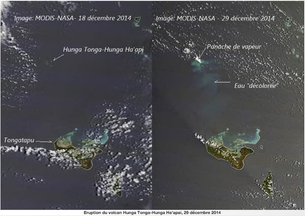
According to a news article, fisherman had reported an eruption at Hunga Tonga-Hunga Ha'apai on 19 December. A photographer in Tongatapu captured a photo of a steam plume rising from the area on 30 December and noted that steam plumes had been visible since 24 December; dense clouds on the horizon prevented views before then. Terra MODIS imagery from 29 December also showed white plumes and areas of discolored water near the islands.
Sabancaya | Peru
Based on reports from INGEMMET, the webcam, and satellite images, the Buenos Aires VAAC reported that on 27 December water vapor and gas plumes from Sabancaya possibly contained small amounts of ash.
HAPPY NEW YEAR to our readers
from all over the World
(including Janine Krippner, currently enjoying 2015 in New Zealand)
Kilauea, Hawaii - December 31, 12:08 UTC (Armand)
USGS Hawaiian Volcano Observatory (HVO) scientists conducted a helicopter overflight of the June 27th lava flow this afternoon and mapped its perimeter. At the time of the flight, the leading tip of the flow was stalled 530 m (580 yd) from the Pahoa Marketplace, but several small breakouts were active immediately upslope from the front. The flow had advanced about 150 m (~165 yd) since December 27. Many small breakouts were also active along the length of the flow up to about 3 km (2 miles) upslope from the front of the flow, as well as within the ground crack area near the True/Mid-Pacific well pad and about 3 km (2 miles) downslope from Puʻu ʻŌʻō.
Fogo, Cabo Verde - December 31, 10:54 UTC (Armand)
Volcanologists in Fogo are reporting a slightly stronger eruption pattern since the last 12 hours
Stromboli, Eolian Islands, Italy - December 31, 12:13 UTC (Armand)
#Stromboli très très rare: de la neige ce matin sur le #volcan/Very rare: snow on the #volcano pic.twitter.com/TM0EbEm1LF
— CultureVolcan (@CultureVolcan) December 31, 2014
Bardarbunga, Iceland - December 30, 17:08 UTC (Armand)
Report of the Scientific Advisory Board earlier today
- Insubstantial changes have been in the volcanic eruption in Holuhraun over the last few weeks. The lava is now flowing inside a closed channel to the eastern edge of the lava field, about 15 km from the crater. Lava is also running to the north.
- Seismic activity in Bardarbunga continues to be strong, but it has though somewhat decreased. The strongest earthquake over the last two days was detected tonight, 30. December, was magnitude M5,3 at 00:11. Eleven earthquakes larger then M3,0 were detected since noon on Sunday and in total around 100 earthquakes were detected in Bardarbunga since noon on Sunday.
- GPS measurements near northern Vatnajokull glacier show continuing slow deflation towards Bardarbunga.
- Telecommunications with the GPS station in Bardarbunga caldera have not been established yet.
Colima, Mexico - December 30, 18:03 UTC (Armand)
#Colima Volcano. Yesterday pic.twitter.com/N359TQ4ZIt
— Volcano Alert (@infoVolcano) December 30, 2014
Fogo, Cabo Verde December 30, 16:59 UTC (Armand)
New satellite lava flow map- Click here to be linked to the "Fogo only" page
Hunga Ha’apai, Tonga eruption - December 30, 11:21 UTC (Armand)
Thanks to @CultureVolcan we were alerted that the in 2009 surfaced volcano (Surtseyan eruption video below) is currently erupting again. CultureVolcan has compiled the latest satellite images of the area and saw an eruption plume clearly on the last one. Again great work by CultureVolcan, which is to our opinion, the best Volcano website in the world (unfortunately in French  )
)
The news was posted by a local Tonga newspaper - The Matangi Tonga (image courtesy and copyright Matangi Tonga).
A continuing eruption from Tonga’s active undersea volcano, Hunga Ha’apai, was clearly visible on the horizon northwest of Tongatapu today. Photographed by Shane Egan from the Kanokupolu coastline, the plume of steam stood out clearly against today’s blue sky. “It’s been puffing away like a steam train since Christmas Eve,” said Shane. “It’s Tonga’s own white Christmas.” He said the eruption may have started earlier but it was hard to see against the heavy clouds on the horizon before Christmas. The eruption was first reported by a fisherman who came back from the area on December 19, according to the Deputy Secretary of Lands and Natural Resources, Taniela Kula, who filed a report to NEMO.
Read the full article here
Below the 2009 impressive Surtseyan eruption. A tourist ship was accidentally navigating in the area and a tourist could make this video, for which we still thank him endlessly.
Bardarbunga, Iceland - December 30, 11:09 UTC (Armand)
From geoscientist on duty this morning : The two largest earthquakes in Bárðarbunga the last 24 hours occurred 14:32 yesterday, M4.4 and 00:11, M5.3. Two more earthquakes around M4.0 were also detected and eight between M3.0 and M4.0. In total ca 40 earthquakes have been detected in Bárðarbunga the last 24 hours.
Popocatepetl, Mexico - December 30, 11:14 UTC (Armand)
https://twitter.com/Popocatepetl_MX/status/549823193146740736
Sinabung, Sumatra, Indonesia - December 30, 11:12 UTC (Armand)
Mt #Sinabung Indonesia Explosión, incandescencia y nube de cenizas Dic.29/2155pm Vía @LeopoldAdam Créditos @endrolewa pic.twitter.com/ROCYayqJYg
— Geól. Sergio Almazán (@chematierra) December 30, 2014
Etna, Sicily, Italy - December 29, 15:22 UTC (Armand)
Etna paroxysm yesterday, the first in quiet some time. Below the strong climb in earthquakes
#etna #etnalive #parossismo #28dicembre #vulcano #sicilia #sicily #cenere #fumo #Photo Francesco Mangiaglia pic.twitter.com/FT5ZkqAmw2
— EtnaLive (@EtnaLive) December 28, 2014
Sheveluch, Kamchatka, Russia - December 29, 10:15 UTC (Armand)
Huge cloud of ash floats over Kamchatka - KAMCHATKA several volcanic eruptions Sheveluch on Saturday, December 27. pic.twitter.com/l048b9GlEN
— Volcano Alert (@infoVolcano) December 29, 2014
Popocatepetl, Mexico - December 28, 17:45 UTC (Armand)
Strong ash explosion at Popocatepetl earlier today
Geysir geothermal field, Iceland December 27, 14:52 UTC (Armand)
An earthquake swarm has started between #Geysir geothermal field & Langjökull glacier #Iceland http://t.co/uttUSFmRaL pic.twitter.com/SNeNQ0LlIf
— Iceland Magazine (@IcelandMag) December 27, 2014
Fogo, Cabo Verde December 27, 13:39 UTC (Armand)
A local expert says that the the eruption may come to an end soon (source Ben Edwards)
Fogo, Cabo Verde December 27, 11:46 UTC (Armand)
#volcan #volcano #Fogo: le point sur la situation/blog update http://t.co/5LxVYQLPVI pic.twitter.com/dR7L5mM6gv
— CultureVolcan (@CultureVolcan) December 27, 2014
Bardarbunga, Iceland - December 27, 11:43 UTC (Armand)
The Holuhraun lava field keeps growing. Now ~81 km2
Colima, Mexico December 24, 18:20 UTC (armand)
#AHORA Volcán de Colima registra fumarola de 800 metros, sin riesgo para población aledaña. Vía @PCJalisco: pic.twitter.com/fRZ4rCqIqE
— Webcams de México (@webcamsdemexico) December 24, 2014
Fogo, Cabo Verde December 24, 16:32 UTC (Armand)
New updated lava flow map + Ilhéu de Losna - Click here to be linked to the "Fogo only" page
Fogo, Cabo Verde December 23, 15:49 UTC (Armand)
Ilhéu de Losna settlement completely destroyed - Click here to be linked to the "Fogo only" page
Fogo, Cabo Verde December 23, 11:49 UTC (Armand)
Done video flying over the devastated villages of Portela and Bangaeira - Click here to be linked to the "Fogo only" page
Fuego, Guatemala December 23, 10:23 UTC (Armand)
#Fuego volcano shows incandescence in the SWIR bands of the EO-1 ALI image from a few days ago pic.twitter.com/cjrQiZBlxg
— Rudiger Escobar Wolf (@rudigerescobar) December 23, 2014
Kilauea, Hawaii December 22, 21:12 UTC (Janine)
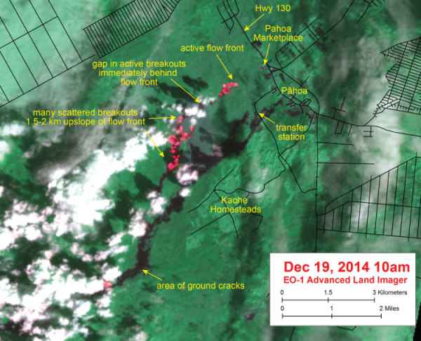
USGS has released an EO-1 Advanced Land Imager false-color image with bright red pixels indicating the high temperatures of the active lava flow. The image shows that activity is not restricted to the flow front and continues up slope. The flow front is widening and is now ~100 m (110 yards) across, and remains ~965 m (0.6 miles) from the Highway 130 and Pahoa Village Road intersection.
Popocatepetl, Mexico - December 22, 18:37 UTC (Armand)
“@webcamsdemexico: El Volcán @Popocatepetl_MX a las 10:56am de esta mañana, gran fumarola pic.twitter.com/g2xMPZNDFT”
— Volcán Popocatépetl (@Popocatepetl_MX) December 22, 2014
Bardarbunga, Iceland - December 22, 16:25 UTC (Armand)
* Insubstantial changes have been in the volcanic eruption in Holuhraun over the last few weeks. The lava is now flowing inside a closed channel to the eastern edge of the lava field, about 15 km from the crater. Lava is also running to the north.
* Seismic activity in Bardarbunga continues to be strong, but it has though somewhat decreased. The strongest earthquake since noon on Friday, 19. December, was magnitude M4,5 yesterday, 21. December, at 16:12 on the southern rim of the caldera. Six earthquakes larger then M4,0 were detected since Friday and about 25 earthquakes
between M3,0-4,0. In total about 135 earthquakes were detected in Bardarbunga since noon on Friday.
* Eighteen earthquakes were detected in the dyke and around the eruption site in Holuhraun since Friday. All smaller then magnitude M2,0.
* GPS measurements near northern Vatnajokull glacier show continuing slow subsidence towards Bardarbunga. The rate of the subsidence has slowly decreased.
* Telecommunications with the GPS station in Bardarbunga caldera have not been established yet. Due to bad weather, over the last few weeks, scientists have not able to travel to Bardarbunga. It is unlikely that any attempt will be made to fix the GPS station until after the holidays.
Erebus, Antarctica- December 22, 09:45 UTC (Janine)
The Erebus Volcano Observatory has released thermal images taken of recent explosions within the active summit lava lake.
Mayon, Philippines - December 22, 09:18 UTC (Janine)
PHIVOLCS reports that the volcano's alert status has been downgraded from Alert Level 3, to Alert Level 2. This results from a reduced likelihood that a hazardous eruption will occur within days to weeks. Mayon remains in a current state of unrest. The edifice is still inflated although ground deformation data from continuous tilt monitoring indicates that the magma body has stalled at depth beneath the northern flank. Entry within the 6 km danger zone is still to be avoided as Mayon volcano may produce sudden phreatic eruptions (water driven), rockfalls, avalanches, ash, and lahars.
Bardarbunga, Iceland - December 22, 09:09 UTC (Janine)
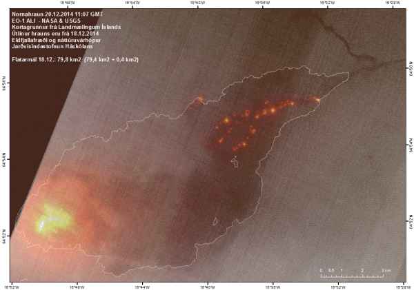
The latest NASA and USGS EO-1 ALI thermal image shows the activity at the northeastern margin, 15 km away from the vent, as of December 20.
Gamalama, Ternate, Indonesia December 21, 09:(! UTC (Armand)
Seismic activity Gamalama in Ternate increased again yesterday. Bursts of hot clouds and thick volcanic ash were noticed.
Fogo, Cabo Verde December 21, 09:19 UTC (Armand)
Drone video footage over the lava fields - Click here to be linked to the "Fogo only" page
A so called "fun video" to proof how lava behaves when you step on it - December 20 (Armand)
Our opinion : Remove it from YouTube in the current form. The video gives the impression that it is fun but writes everywhere that you should not do it. 2.5 million people shared this video in 8 days. We are absolutely convinced that some people will also try it if they can get to a lava field. The chance that you will loose a foot is relatively high. Lava has a temperature of 1000 to 1200 °C. + we do not believe that the person is a professional and even less that he would approve showing this video on YouTube.
Kilauea, Hawaii December 20, 16:11 UTC (Armand)
Advancement of the flow continued at a slower rate, compared to earlier in the week, and the flow moved about 120 meters (130 yards) in the past 24 hours. A southern branch of the flow on this map was stalled when mapped this morning. The more northerly advancing branch was 0.9 km (0.6 miles) away from the back of the Pahoa Marketplace, measured in a straight line. A HAWAII County Civil Defense overflight this afternoon observed about 40 yards advance over the past 12 hours suggesting further slowing.
While the flow fronts were slowing, there was abundant evidence of inflation (see photos) indicating that both branches remained active.
Popocatepetl, Mexico - December 20 (Armand)
Popocatetl is know for his exhalation (or explosions). The compressed map below shows 5 of them . The other map shows the number of tremor minutes during the last week and the number of explosions during the same period.
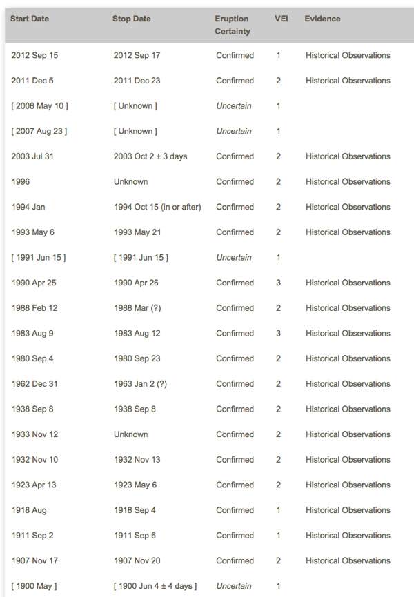
Gamalama, Ternate, Indonesia - December 19, 13:31 UTC
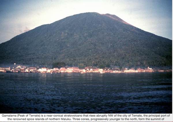
One hiker is missing and nine have been injured after Mount Gamalama in Ternate, North Maluku, erupted on Thursday, sending thick plumes of volcanic ash across the island. The volcano erupted about 10 p.m. local time on Thursday, spewing ash and smoke hundreds of meters into the air, and blanketing dozens of villages on Ternate. The island’s main airport, Sultan Babullah Airport, was forced to close this morning due to poor visibility. Indonesia’s National Disaster Mitigation Agency (BNPB) on Thursday said nine hikers, who were on the flanks of the volcano when it erupted, were injured while trying to run to safety.
“The hikers were injured when they were trying to save themselves from the eruption,” said BNPB spokesman Sutopo Purwo Nugroho, as quoted by Tempo.co. Four hikers with serious injuries are being treated in Ternate hospital, Sutopo said. The five others, who suffered light injures, have returned home. A search and rescue team of about 80 people was deployed to search for one hiker still missing. “The victim missing was one of the hikers who were climbing Mount Gamalama since Wednesday,” Sutopo said.
Several flights to and from Sultan Babullah Airport have been canceled today and the airport remains closed. (Source Jakarta Globe)
Bardarbunga, Iceland - December 19, 13:08 UTC (Armand)
Report of the Scientific Advisory Board earlier today
* Insubstantial changes have been in the volcanic eruption in Holuhraun over the last few weeks. Indication show that the lava is now mainly flowing inside closed channels except closest to the crater. One of the main lava channels is now flowing to the north.
* Seismic activity in Bardarbunga continues to be strong. The strongest earthquake since noon on Tuesday, 17. December, was magnitude M5,3 on Wednesday, 17. December, at 13:59 on the northern rim of the caldera. The earthquake was felt in Akureyri. About 6 earthquakes between M4,0-5,0 were detected since Tuesday. In total about 200 earthquakes were detected in Bardarbunga since noon on Tuesday.
* About 20 earthquakes were detected in the dyke and around the eruption site in Holuhraun since Tuesday. All smaller then magnitude M2,0.
* GPS measurements near northern Vatnajokull glacier show continuing slow subsidence towards Bardarbunga. The rate of the subsidence has slowly decreased.
* Yesterday, 18. December, scientists flew over Bardarbunga. The data collected in the flight show that the subsidence of the caldera continues with similar rate as before. The caldera has subsided between 4-5 meters since 4. December and the south caldera rim has subsided between 7-8 meters since the beginning of the seismic activity in August.
* Telecommunications with the GPS station in Bardarbunga caldera have not been established yet. Due to bad weather forecast it is unlikely that scientists will be able to travel to Bardarbunga in the next few days. A connection will be established with the GPS station as soon as possible.
White Island, New Zealand
Great pic of #WhiteIsland #volcano #NewZealand Photo by Volcano Air pic.twitter.com/cnonbMgRcy
— Roberto C. Lopez (@Bromotengger) December 19, 2014
Kilauea, Hawaii December 18, 20:06 UTC (Janine)
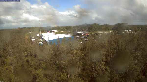
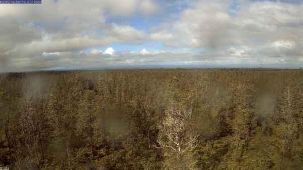
HVO reports that the active flow front is now 1.3 km (0.8 miles) from the Pahoa Village Road and Highway 130 intersection, after advancing approximately 150 m (165 yards) since yesterday. The flow consists of two closely-spaced, narrow lava flow fingers that are heading in the same direction, and may be slowing. HVO staff have put in place 2 time lapse web cams near the Pahoa Marketplace, one focusing on the market, and the other up slope. The current webcam images are below.
Gamalama, Ternate, Indonesia erupts - December 18, 18:09 UTC
Volcan Gamalama had 2 ash explosions a little earlier. 10 people did notice the authorities that they would climb the volcano. Since then no news. Depending on their climbing route and level at the time of the explosions, their situation maybe very harmful. We can compare this ash explosion best with the many people killed on the Ontake volcano in Japan. Lets hope that everyone will reach a safe location asap. We will keep you updated about their faith.
Gamalama is currently in Waspada or level II on a IV scale alert since October 9 2014
Volcano activity of the world (last 7 days) – December 18, 15:00 UTC (Armand)
Bulletin collected and published by the Smithsonian Institute
 Asosan | Kyushu (Japan)
JMA reported that, based on seismicity and infrasound data, the eruption from Asosan’s Nakadake Crater that began on 25 November continued during 8-12 December; inclement weather often prevented observations of the crater. A webcam recorded tephra being carried by high winds and deposited in an area 1 km W. During a field survey on 10 December volcanologists observed 20-cm-wide blocks near the crater and 5-10-cm-wide blocks within 1.2 km SW of the crater. Plumes rose 600 m above the crater and incandescent material was sometimes ejected onto the crater rim. During 12-15 December the plume rose 1 km above the crater rim. Ashfall was reported E in Hanoi Aso (Kumamoto Region). Incandescent material was occasionally ejected onto the crater rim. The Alert Level remained at 2 (on a scale of 1-5).
Chirinkotan | Kuril Islands (Russia)
SVERT reported that a thermal anomaly over Chirinkotan was detecetd in satellite images during 10-11 and 13-14 December. Cloud cover obscured views on the other days during 8-15 December. The Aviation Color Code remained at Yellow.
Fogo | Cape Verde | 14.95°N, 24.35°W | Elevation 2829 m
According to news articles the rate of lava output from Fogo's Pico cone inside the Cha Caldera had decreased on 9 December and remained low through 14 December. Gas and ash emissions also decreased and were almost absent by 14 December. Even though output was low, the remaining buildings in the town of Bangaeira were overtaken by lava.
Kusatsu-Shiranesan | Honshu (Japan) | 36.618°N, 138.528°E | Elevation 2165 m
During 5-12 December JMA maintained Alert Level 2 for Kusatsu-Shiranesan due to continued unrest. GPS measurements indicated inflation, although thermal anomalies had been absent since July. Volcanic earthquakes continued at a low level and tremor was absent.
Lopevi | Vanuatu | 16.507°S, 168.346°E | Elevation 1413 m
On 15 December the Vanuatu Geohazards Observatory reported that, based on observations and analyses in early December, activity at Lopevi had increased dramatically over a short time period. The Alert Level was raised to 1 (on a scale of 0-4), and access to the island was prohibited.
Moyorodake [Medvezhia] | Iturup (Etorofu) Island (Japan/Russia) | 45.389°N, 148.838°E | Elevation 1124 m
On 12 December SVERT reported that activity at Kudriavy, a stratovolcano of the Medvezhia volcanic complex, had not increased since 1 December. The Aviation Color Code was lowered to Green.
Nevado del Ruiz | Colombia | 4.895°N, 75.322°W | Elevation 5321 m
Servicio Geológico Colombiano’s (SGC) Observatorio Vulcanológico and Sismológico de Manizales reported that on 15 December at 0738 seismic signals indicating ash emissions were detected, and then confirmed, by a local webcam and residents. Based on a pilot observation, the Washington VAAC noted that an ash plume drifted almost 20 km S that same day. The Alert Level remained at III (Yellow; "changes in the behavior of volcanic activity").
Source: Servicio Geológico Colombiano (SGC)
Sinarka | Shiashkotan Island (Russia) | 48.875°N, 154.175°E | Elevation 934 m
SVERT reported that on 8 December satellite images of Sinarka showed diffuse steam-and-gas emissions. Cloud cover obscured views on the other days during 9-15 December. The Aviation Color Code was raised to Yellow.
Villarrica | Chile
According to Projecto Observación Visual Volcán Villarrica (POVI), satellite images of Villarrica acquired on 10 and 26 November and 3 December revealed a progressively more intense thermal anomaly. Photographs on 9 December showed particulates suspended above the crater rim, and the next day a thin veneer of ash covered the NW edge of the crater rim. Detonations from the crater were heard during 10-12 December. On 13 December observers noted that the intense blasts of gas from the previous few days had removed some ash deposits from the inner crater wall leaving lighter colored streaks.
Zhupanovsky | Eastern Kamchatka (Russia)
KVERT reported that an eruption at Zhupanovsky continued during 5-12 December. Satellite images detected a thermal anomaly on 9 December; the volcano was either quiet or obscured by clouds on the other days. The Aviation Color Code remained at Orange.
Fogo, Cabo Verde December 18, 17:03 UTC (Armand)
New lava flow map - Click here to be linked to the "Fogo only" page
Sinabung, Sumatra, Indonesia - December 18, 11:58 UTC (Armand)
If you love pyroclastic flows and explosive volcanoes, book a ticket to Indonesia and have the time of your life (at least when you respect the safety parameters)
#Sinabung by @BeidarSinabung Rumbled at noon Dec 18,2014-12:50 pm View Payung village @infobencana @chematierra pic.twitter.com/nZXrNLlpND
— Leopold Kennedy Adam (@LeopoldAdam) December 18, 2014
Bardarbunga, Iceland - December 18, 11:58 UTC (Armand)
Nice view of the Holuhraun eruption on the webcams right now in Iceland http://t.co/e9Cwq8Dx1k #Volcano pic.twitter.com/bLmH9JwyYV
— Janine Krippner (@janinekrippner) December 18, 2014
Bardarbunga, Iceland - December 17, 14:33 UTC (Armand)
A strong M5.3 earthquake at the Bardarbunga rim was felt in large parts of Iceland. The earthquake is however nothing special and is in line with earlier near M5 quakes, this mainly because of the depth of the hypocenter at 6.9 km.
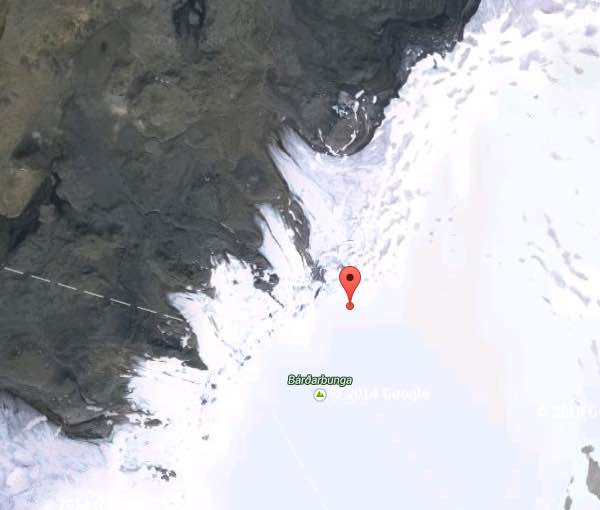
Bardarbunga, Iceland - December 17, 12:41 UTC (Armand)
Gradual fading of seismic activity at Bárðarbunga and the dyke intrusion (since the events of 16th August 2014)
The earthquake sequence around Bárðarbunga in 2014 continues at high levels, but has shown clear signs of gradual fading during the last weeks and months. This slow decay of activity is reflected by lower magnitudes and numbers of earthquakes, seen as a general decrease of seismic moment release.
The figure shows the decrease of seismic moment release and numbers of events with respect to time between the onset of the earthquake swarm on 16 August (week 0) and today, 16 December (week 18). The cumulative moment and numbers of events are calculated for each week; i.e. for each week the earthquakes of certain magnitude ranges were counted and the moment of all earthquakes was simply summed up.
Read the full article here
Ruapehu, New Zealand - December 17 12:37 UTC (Armand)
Mt Ruapehu crater lake taken from a routine gas flight this week #volcano pic.twitter.com/CtUOuj1Tq7
— GeoNet (@geonet) December 17, 2014
Asosan, Japan - December 17 12:37 UTC (Armand)
Strombolian activity last night at #Aso #volcano #Japan Photo via http://t.co/wXW579Q3JE pic.twitter.com/mzA0XlIsG7
— Roberto C. Lopez (@Bromotengger) December 16, 2014
Tokashidake, Hokkaido, Japan - December 16 23:31 UTC (Armand)
JMA increased the volcanic alert from 1 to 2 on a scale of 5 (Do not approach the crater) due to increased seismicity
Summary : Tokachidake volcano consists of a group of dominantly andesitic stratovolcanoes and lava domes arranged on a NE-SW line above a plateau of welded Pleistocene tuffs in central Hokkaido. Numerous explosion craters and cinder cones are located on the upper flanks of the small stratovolcanoes, with the youngest Holocene centers located at the NW end of the chain. Frequent historical eruptions, consisting mostly of mild-to-moderate phreatic explosions, have been recorded since the mid-19th century. Two larger eruptions occurred in 1926 and 1962. Partial cone collapse of the western flank during the 1926 eruption produced a disastrous debris avalanche and mudflow. (source: Smithsonian Institute)
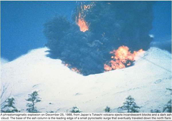
Photo courtesy of Japan Meteorological Agency, 1988.
Science - Behavior of different type of lava in contact with snow - December 16 (Armand)
Volcano observations reveal jets of steam shooting out of the ice and lava moving like a giant caterpillar – although the lava type can make a big difference
For Your Information (Armand)
We have cut a big part of this page, the part from December 5 until December 13. The link to this archived part is or here or at the bottom of the page.
Bardarbunga, Iceland - December 15, 23:34 UTC (Armand)
Report of the Scientific Advisory Board earlier today
* Insubstantial changes have been in the volcanic eruption in Holuhraun over the last few weeks. Indication show that the lava is now mainly flowing inside closed channels.
* Seismic activity in Bardarbunga continues to be strong. The strongest earthquake since noon on Friday, 12. December, was magnitude M5,4 yesterday, 15. December, at 09:37 on the northern rim of the caldera. About 20 earthquakes larger then M4,0 were detected since Friday. In total about 200 earthquakes were detected in Bardarbunga since noon on Friday. A collection of data from the beginning of the seismic activity in Bardarbunga show a steadily decline in the seismic activity and in the number of large earthquakes.
* On Saturday and Sunday, 13. and 14. December, a minor increased seismic activity was detected in the dyke and around the eruption site in Holuhraun. Between 15 and 20 earthquakes were detected each day, all smaller then magnitude M2,0. Since then about 10 earthquakes a day were detected in the dyke, all smaller then magnitude M2,0.
* GPS measurements near northern Vatnajokull glacier show continuing slow subsidence towards Bardarbunga. The rate of the subsidence has slowly decreased.
* Telecommunications with the GPS station in Bardarbunga caldera have not been established yet. Due to bad weather forecast it is unlikely that scientists will be able to travel to Bardarbunga in the next few days. A connection will be established with the GPS station as soon as possible.
2014: The Year in Volcanic Activity (Armand)
40 great pictures of eruptions in 2014. Enjoy them. Due to Copyright reasons we cannot reproduce the photo's
Read the full article here
Zhupanovsky, Russia December 06, 09:17 UTC (Janine)
The Tokyo VAAC has released an ash advisory after an ash plume has been reported to be traveling 70 km to the southeast. KVERT reports that moderate activity continues at the volcano.
Shiveluch, Russia December 06, 09:17 UTC (Janine)
KVERT reports the continuation of the lava dome growth with moderate explosions, avalanches, and fumerolic activity. The Tokyo VAAC has released an ash advisory after satellite data shows an ash plume moving up to 109 km to the southeast, accompanying a thermal anomaly at the summit dome.
Sinabung, Indonesia December 06, 08:56 UTC (Janine)
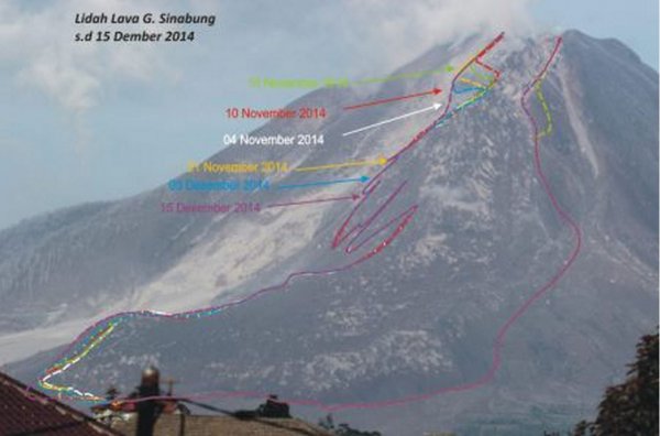
The Badan Geologi has released an updated map of the summit dome with a length of 215 m, and lava lobe which is now 2,947 m long. Between December 8-15 the instability of the lobe and dome has resulted in an average of 184 seismic events per day. In this period 53 pyroclastic flows have been recorded, traveling up to 4,500 m to the south, and a maximum of 1,000 m to the southeast. The current threat is believed to be limited to a radius of 5 km.
Kilauea, Hawaii December 16, 08:46 UTC (Janine)
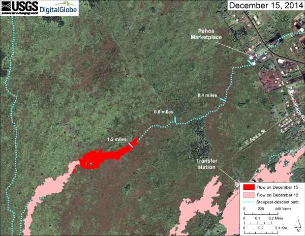
The active lava flow front was last measured to be approximately 1.8 km (1.1 miles) from the Pahoa Marketplace after traveling 0.8 km (0.5 miles) in just under 3 days. No evacuation has yet been ordered but the Marketplace merchants are on evacuation notice.
Bardarbunga, Iceland - December 15, 23:34 UTC (Janine)
The Institute of Earth Sciences has released an updated map of the Holuhraun lava field from December 12. The lava field is now 78.6 km² in size. An ESA Sentinel 1 radar image taken the same day shows the cauldrons in the icecap above Bardarbunga volcano that have formed during the eruption.
Nevado del Ruiz, Colombia December 15, 18:35 UTC (Armand)
Powerful explosion on a timelapse video + a spectogram showing the tremor at the start of the eruption
Fogo, Cabo Verde December 15, 17:54 UTC (Armand)
Lava front advance has considerably decreased + new map - Click here to be linked to the "Fogo only" page
Fogo, Cabo Verde December 14, 22:01 UTC (Janine)
Photos of damage caused by the lava flow in Portela and Bangaeira from the Asociación Canaria de Volcanología. - Click here to be linked to the "Fogo only" page
Kilauea, Hawaii December 14, 21:45 UTC (Janine)
The lava flow has advanced approximately 274 m (300 yards) east-northeast since yesterday and is now 2.25 km (1.4 miles) upslope of the Highway 130 and Pahoa Village Road intersection. There is no immediate threat to communities. The Hawaii County Civil Defense released the updated map below showing the current position of the new flow front.
Reventador, Ecuador - December 14, 12:18 UTC (Armand)
#volcan #volcano #Reventador belle petite colonne de cendres, bien régulière/nice & regular small ash column pic.twitter.com/xXFOVjZWCj
— CultureVolcan (@CultureVolcan) December 14, 2014
Sinabung, Sumatra, Indonesia - December 14, 11:39 UTC (Armand)
Volcán Mt #Sinabung Indonesia Gran flujo piroclastico Vía @SinabungVolcan Créditos: @endrolewa Dic.13/16:27h. pic.twitter.com/cRnnLyseYi
— Geól. Sergio Almazán (@chematierra) December 14, 2014













A huge landslide generated tsunami waves damaging some villages in Greenland - 4 people (remain) missing