 On this page : Sakurajima, Fogo, Kilauea, Fuego, Bardarbunga, Azumayama, Sinabung, Merapi, Kizimen, Vocano activity of the week overwiews, Turriabla, Aso, Tungurahua, Erebus, Popocatepetl, Pavlov, Chiles and Cerro Negro, Reventador, Mayon and Stromboli
Click here to read the latest part of our report
This report is compiled out of many information sources.
For our El Hierro volcano report : Click here
Sukurajima, Japan - December 13, 10:25 UTC (Armand)
Big explosion of #Sakurajima #volcano in #Japan today captured by the webcams pic.twitter.com/MwqIGIhtLH
— Roberto C. Lopez (@Bromotengger) December 13, 2014
Fogo, Cabo Verde December 13, 10:21 UTC (Armand)
A video from Fogo news (Portuguese) stating the the eruption is stable but ongoing - Click here to be linked to the "Fogo only" page
Kilauea, Hawaii December 13, 10:19 UTC (Armand)
USGS Hawaiian Volcano Observatory (HVO) scientists conducted field mapping around the leading tip of active lava on the June 27th lava flow. The active lobe has advanced about 900 meters (0.6 miles) since the afternoon of December 9, which is equivalent to an average advance rate of approximately 320 meters per day (0.2 miles per day).
The leading edge of this lobe was 2.7 km (1.7 miles) upslope from the intersection of Highway 130 and Pāhoa Village Road at the Pahoa Marketplace, as measured along a straight line. The active lobe is following a steepest-descent path that takes the flow towards the intersection of Pāhoa Village Road and Highway 130, in the vicinity of the Pahoa Marketplace. The leading edge of the lobe was 2.6 km (1.6 miles) upslope from the edge of Pahoa Marketplace, as measured along this path of steepest-descent.
Fuego, Guatemala - December 12, 17:33 (Armand)
An active night at Fuego. Larger explosions produce ground-coupled air waves that appear as large amplitude... http://t.co/8XitaLODGa
— Greg Waite (@Greg_Waite) December 12, 2014
Bardarbunga, Iceland - December 12, 15:07 UTC (Armand)
Below a video we like a lot, mainly because it tells you where it all began, how it proceeded and what it finally became. Simply the best 8 minutes explanatory video we have seen so far.
Bardarbunga, Iceland - December 12, 15:00 UTC (Armand)
Seismic activity around Bárðarbunga continues at similar high rates as in recent days. Activity in the dyke intrusion is low. The strongest earthquake since the last report yesterday morning was magnitude 4.6 yesterday at 12:40 on the northern caldera rim. Six additional earthquakes exceeded magnitude 4 and another 15 were in the range M3-4. All together around 40 earthquakes were detected around the caldera in the last 24 hours. Around 10 earthquakes were detected in the dyke intrusion, all of them smaller than magnitude 1. No visibility on cameras due to bad weather.

Landsat 8 thermal image from NASA USGS yesterday. The lava is now 77,5 km² (77,1 km² + 0,4 km²). East of the empty patch there is now a glowing tongue of magma - Click on this image to enlarge
Fogo, Cabo Verde December 12, 13:12 UTC (Armand)
A brand new superlative video from Dr. Richard Roscoe, Do not forget to watch it - Click here to be linked to the "Fogo only" page
Fogo, Cabo Verde December 12, 11:16 UTC (Armand)
OCHA (Office for the Coordination of Humanitarian Affairs) latest Fogo report - Click here to be linked to the "Fogo only" page
Azumayama, Japan - December 12, 10:12 UTC (Armand)
JMA Japan has increased the alert level from 1 to 2 (5 levels). Level 2 means: "Do not approach the crater". In 2001 a similar alert level was called due to increased seismicity. The volcano is located in the Fukushima prefecture The increased seismicity may not, repeat not, have any connection with the Nuclear power plant in the same prefecture :).
Bardarbunga, Iceland - December 12, 09:50 UTC (Armand)
The Bardarbunga Holuhraun fissure eruption SO2 emission is on his way to set a new world record.
Sinabung, Sumatra, Indonesia - December 12, 09:44 UTC (Armand)
#Sinabung pyroclastic flow view Gamber by @galuh_paten Dec 11,2014 - 07:30 am @infobencana @chematierra @karo_news pic.twitter.com/HLrkJyn6cL
— #Sinabung (@SinabungVolcan) December 12, 2014
Merapi, Java, Indonesia - December 12, 09:27 UTC (Armand)
#Merapi Dec 12, 2014 - 10:25 am view Kemalang @Induk_Balerante @pasagmerapi @purpalaofficial @infopendaki pic.twitter.com/HeqdSZP9Fj
— #Sinabung (@SinabungVolcan) December 12, 2014
Fogo, Cabo Verde December 12, 00:52 UTC (Armand)
New short video of the eruption during the first days of December - Click here to be linked to the "Fogo only" page
Kizimen, Kamchatka - December 11, 23:55 UTC (Armand)
#Kizimen #volcano in #Kamchatka steaming right now as shown by the #webcams pic.twitter.com/EuZ3ren5Jq
— Roberto C. Lopez (@Bromotengger) December 11, 2014
Earthquake-Report.com (Armand)
If you like what we do (both for earthquakes and volcanoes) and you are a tweep (name for Twitter user), do not forget to follow us on the account shown on the picture + a gift of a couple of $'s now and then would make us even more motivated :). Thank You
Volcano activity of the world (last 7 days) - December 11, 10:29 UTC (Armand)
Bulletin collected and published by the Smithsonian Institute
Asosan | Kyushu (Japan)
JMA reported that, based on seismicity and infrasound data, the eruption from Asosan’s Nakadake Crater that began on 25 November continued during 1-8 December; inclement weather often prevented observations of the crater. A webcam recorded incandescent material being ejected from the crater at night. A very small amount of ashfall was observed at Sensui Gorges, 2 km NE on 3 December. The Alert Level remained at 2 (on a scale of 1-5).
Chirinkotan | Kuril Islands (Russia)
SVERT reported that satellite images of Chirinkotan showed a thermal anomaly during 2-5 and 7 December, and diffuse gas-and-steam emissions on 3 December. Cloud cover obscured views on the other days during 1-8 December. The Aviation Color Code remained at Yellow.
Fogo | Cape Verde
According to news articles the eruption from Fogo's Pico cone inside the Cha Caldera continued during 3-9 December. The eruption became more intense on 6 December with lava flows traveling at a rate of 30 meters per hour. By that afternoon 20 houses in the N half of Portela had been destroyed, and authorities ordered a complete evacuation of the area. The third access road that allowed for residents to retrieve property was being covered by lava. Later that day lava reached the town of Bangaeira. More than half of Bangaeira was inundated by the very fluid lava and by the evening only a few houses remained. Flights from the island to a few other locations were cancelled due to ash emissions. By 8 December about 90% of Bangaeira and 95% of Portela were overtaken by the flows which, and as noted by the article, destroyed 100 years of town history. After moving through the towns the lava-flow front was about 300 m wide. By 8 December the almost 1,500 residents of the caldera had been evacuated, with 848 of them in shelters. Lava-flow advancement slowed on 9 December.
+ our own in-depth reporting (of course)
Sinarka | Shiashkotan Island (Russia)
SVERT reported that on 3 December satellite images of Sinarka showed steam-and-gas emissions with small amounts of ash drifting 40 km NE. Diffuse steam-and-gas emissions were observed on 6 December. Cloud cover obscured views on the other days during 1-8 December. The Aviation Color Code was raised to Yellow.
Turrialba | Costa Rica
OVSICORI-UNA reported that at 2128 on 8 December a strong Strombolian explosion at Turrialba lasted about 10 minutes and had no precursory activity. Ashfall (1 cm thick) and ballistics were deposited as far as 300 m W. Trace amounts of ashfall were reported in the Central Valley and in towns to the W and SW.
Zhupanovsky | Eastern Kamchatka (Russia)
KVERT reported that ash explosions at Zhupanovsky continued during 25 November-1 December. Ash plumes rose to an altitude of 6 km (19,700 ft) a.s.l. and drifted 422 km E and SE during 28 November-1 December. Satellite images detected a thermal anomaly during 28-29 November; the volcano was either quiet or obscured by clouds on the other days. The Aviation Color Code remained at Orange.
Kilauea, Hawaii December 11, 10:21 UTC (Armand)
‘Paradise tax’: the price Hawaiians are prepared to pay for living near volcanoes
The destruction caused by the lava of Kilauea are grabbing the attention of the international media. Last week, footage showed this eruption claiming its first house in Pahoa and people began to question whether to try to halt the flow of lava and how you might go about it.
But the daughter of the family’s home that was destroyed was remarkably sanguine about losing the family home:
If you’re going to live on a volcano, it’s about her (the Hawaiian Goddess Pele), not us … if she wants her land back, then get out of the way. I like to call it ‘paradise tax’.
The volcano is part of their culture. Pele is such a dominant force in Hawaiian’s lives they tend to accept the possibility that it might erupt. For a lot of Hawaiians, their respect for the volcano god appears to override their fear of eruptions.
For instance, the now-displaced family is building another home on older, solidified lava. Hawaii is entirely volcanic due to being situated on a hot spot resulting in a continual output of volcanic material. As far as I am aware, the family did not have insurance. This shows their ability to bounce back and recover from a hazardous event.
Not everyone responds in the same way. Some people are scared, some panic or remain anxious. And yet Hawaiian people have dealt with Kilauea’s almost continuous eruption for more than 50 years now. Over the course of many generations, they are actively learning about the volcano and the risks it poses.
Read the full article here
Fogo, Cabo Verde December 11, 10:13 UTC (Armand)
2 new updates a) why aren't we seeing Fogo in the international press b) new lava map - Click here to be linked to the "Fogo only" page
Kilauea, Puʻu ʻŌʻō, Hawaii - December 10, 19:31 UTC (Armand)
USGS Hawaiian Volcano Observatory (HVO) scientists conducted an overflight this afternoon, mapping and observing the entire length of the active lava flow erupting from Puʻu ʻŌʻō. The active lobe that branched off the west edge of the flow field downslope from the crack system has advanced about 300 m (330 yd) since December 7. During the past 2 days, the average advance rate is 150 m/day (165 yd/day), which is less than half the advance rate of last week.
The leading edge of this lobe was 3.4 km (2.1 mi) upslope from the intersection of Highway 130 and Pāhoa Village Road at the Pahoa Marketplace. Along its length, the width of this lobe varies between about 80 m (90 yd) to 330 m (360 yd). The active lobe is following a steepest-descent path that takes the flow towards the intersection of Pāhoa Village Road and Highway 130, in the vicinity of the Pahoa Marketplace.
In addition to this active lobe, a breakout from the lava tube on December 5, about 2.6 km (1.6 mi) from Puʻu ʻŌʻō remains weakly active. The breakout is about 1 km (0.6 mi) long, and has widened the flow field in this area by about 200 m (220 yd).
Bardarbunga scientific Advisory Board, Iceland December 10, 15:17 UTC (Armand)
Insubstantial changes have been in the volcanic eruption in Holuhraun over the last few weeks. The lava is now also flowing towards east northeast into the small island in the centre of the lava field. This change can be seen from web cameras.
* Seismic activity in Bardarbunga continues to be strong. The strongest earthquake since noon on Monday, 8. December, was magnitude M4,9 on Tuesday at 18:00. About 20 earthquakes larger then M3,0 were detected since Monday. In total about 180 earthquakes were detected in Bardarbunga since noon on Monday.
* Little seismic activity was detected in the dyke and around the eruption site in Holuhraun since Monday. It worth noting that the storm, now going over Iceland, reduces the sensitivity of the seismograph system, making it harder to detect small earthquakes.
* GPS measurements show no changes. The subsidence towards Bardarbunga continues with similar rate as has been.
* Telecommunications with the GPS station in Bardarbunga caldera have not been established yet. Due to bad weather forecast it is unlikely that scientists will be able to travel to Bardarbunga in the next few days. A connection will be established with the GPS station as soon as possible.
Bardarbunga, Iceland December 10, 11:20 UTC (Armand)
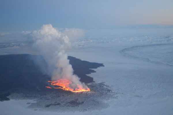
A sea of lava was the description below this image of the University of Iceland - picture taken during yesterdays overflight.
In 100 days, over 1 km3 of lava erupted that covers area of 77 km2. No end in sight.
Sinabung, Indonesia December 10, 00:39 UTC (Janine)
Fogo, Cabo Verde December 9, 16:53 UTC (Armand)
And another great Close-By video from Involcan, certainly a Must See - Click here to be linked to the "Fogo only" page
Turrialba, Costa Rica December 9, 16:10 UTC (Janine)
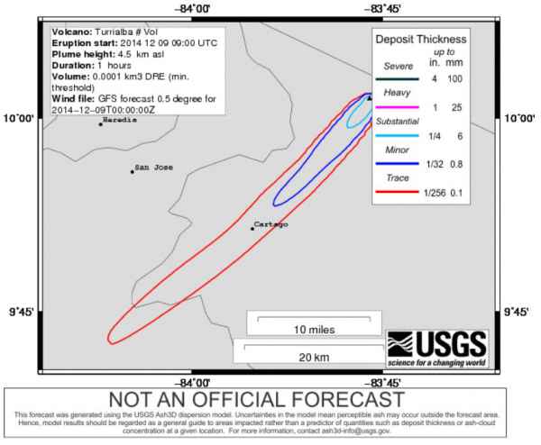
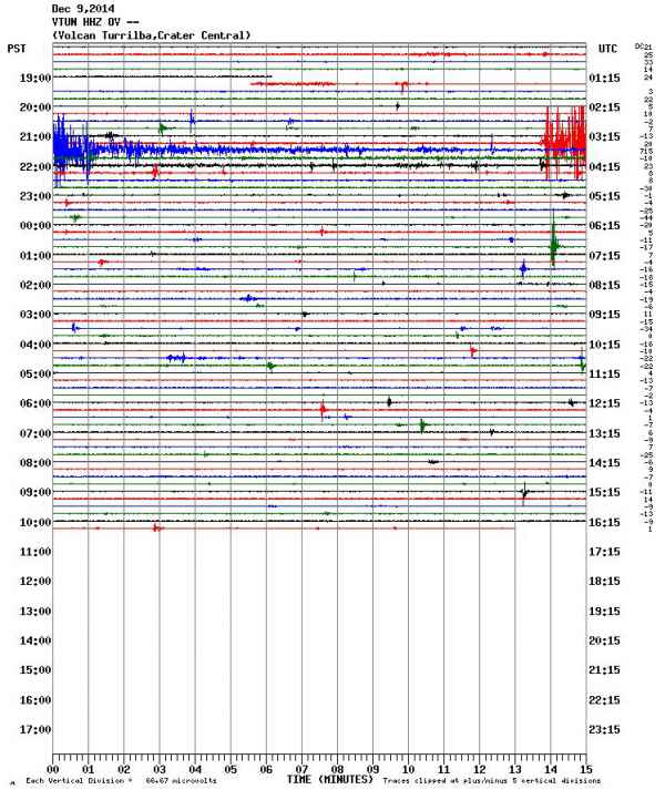
Costa Rica's Observatorio Vulcanológico y Sismológico de Costa Rica Universidad Nacional (OVISCORI-UNA) has reported an ash eruption at Turrialba volcano. Nearby residents have been reporting ashfall and a preliminary potential ash deposit scenario has been given by USGS. This correlates with the increase in seismic activity as seen below.
Asosan, Kyushu, Japan December 9, 15:50 UTC (Armand)
#Explosions at #Aso #volcano #Japan today captured by the webcams pic.twitter.com/btI35TBEVp
— Roberto C. Lopez (@Bromotengger) December 9, 2014
Sinabung, Indonesia December 9, 15:08 UTC (Armand)
[2] 09/12-12:55am @BeidarSinabung pyroclastic flow,glided 3.5km-South ash column 1.5km @infobencana @chematierra pic.twitter.com/eOvlOLbfyq
— Leopold Kennedy Adam (@LeopoldAdam) December 9, 2014
Fogo, Cabo Verde December 9, 13:21 UTC (Armand)
2 great new (Fogonews) videos you certainly will love - Click here to be linked to the "Fogo only" page
Tungurahua, Ecuador - December 9, 11:39 UTC (Armand)
How Ecuadorian communities and scientists are linking up to reduce the risk of one of South America’s most active volcanoes.
Jonathan Stone is a PhD researcher at the School of Environmental Sciences, University of East Anglia, working in volcanology and disaster risk reduction. His research focuses on the interactions between citizens, scientists and authorities around volcanoes, examining the effects of citizen science on these relationships. Although his background is in Geology, with an MSc in the Science of Natural Hazards, Jonathan went on to study for an MRes in Environmental Social Sciences before starting a PhD funded by the Economic and Social Research Council and the British Geological Survey. This experience (expertise in) of both the natural and social sciences has lead him to work on the Strengthening Resilience in Volcanic Areas (STREVA) project.
Outside of research, Jonathan is passionate about public engagement and was one of the creators of Volcanoes Top Trumps. More recently he has been involved in producing a series of short documentaries about the societal impact of volcanoes, told by the voices of those who lived through eruptions in St Vincent, West Indies. He likes running in his spare time, being involved in his local church – and of course – climbing volcanoes.
Read the full article here
Volcanology - December 9, 10:05 UTC (Armand)
Considering a GeoTenerife Volcanic Risk and Geothermal Exploration Internship? See this video interview with David Calvo
Fogo, Cabo Verde December 9, 09:40 UTC (Armand)
A number of maps with the lava stream trajectory - Click here to be linked to the "Fogo only" page
Fogo, Cabo Verde December 9, 00:56 UTC (Armand)
New evening news video showing the lava streams - Click here to watch it
Update December 9, 00:34 UTC (Armand)
We have now archived the November 29 until December 4 part. Updates about the following volcanoes : Fogo (Cabo Verde), Nevado del Ruiz (Colombia), Aso (Japan), Chiles and Cerro Negro (Colombia), Copahue (Chile),Ubinas and Sabancaya (Peru), Bardarbunga (Iceland), El Hierro (Canary Islands), Nishinoshima (Japan), Shishaldin (Alaska), Ruapehu (New Zealand), Kilauea (Hawaii), Stromboli (Italy), Santiaguito (Guatemala), Kuril Islands volcanoes (Russia) - Link to this part and to all the previous parts also at the bottom of this page
Important FOGO news update December 8, 23:41 UTC (Armand)
We have just created a FOGO ONLY page as Janine and myself decided that we have to many updates and as the Fogo Cabo Verde people should have a page of their own. The format will be the same as our extensive El Hierro report.
If the page gets too long, an archived part will be made and the link to it will be at the bottom of the Fogo page. Every time the Fogo page gets an update, we will also refer to this update with a line and a link on this page. We invite our FOGO news followers to assist us in gathering information for this new page (as with other information too). The Fogo page will be refreshed automatically every 30 minutes if you keep it open in a browser tab. Pay it a visit and share it with friends who are also following the Fogo volcano eruption. Thank You
Popocatepetl, Mexico December 8, 23:40 UTC (Janine)
Video of a short explosion earlier today
Fogo, Cabo Verde December 8, 21:41 UTC (Janine)
The below two maps posted by the Asociación Canaria de Volcanología shows the progression of the lava flows. The flows mapped in darker orange are the most fluid lavas that have devastated the villages Portela and Bangaeira. The second map is the most recent from December 7, the more fluid lavas have traveled further north.
Fogo, Cabo Verde December 8, 15:47 UTC (Armand)
The Prime Minister of Cabo Verde will publish an order to evacuate new areas on the island due to what he says is "increased (lava flow) activity" of the volcano. Almost the whole volcano caldera is being blocked by the military as nobody may enter it except geologists and volcanologists, a decision the population does not agree. More and more people are criticizing the authorities for the way they are handling the evacuation.
Fogo, Cabo Verde December 8, 15:29 UTC (Armand)
It is feared that due to the steeper slope and the flood increase speed some locations as Tinteira (municipality of Santa Catarina), Relva, Achada Grande and other nearby locations in the county of the Mosteira may be endangered. Geologist Sonia Silva of the University of Cape Verde said that at present it is impossible to make predictions as to whether the lava in its descent of the volcano and before eventually reaching the sea will hit Monte Velha or places like Tinteira, Relva, Achada Grande and Corvo all located in the northeast of the island.
Erebus, Antarctica December 8, 16:28 UTC (Armand)
Cargo/Recce flight postponed today. This is common. Time to see the sights: Erebus volcano next door #AntarcticaG297 pic.twitter.com/1o52e4wHLA
— Trevor Williams (@Trevor_on_ice) December 8, 2014
Fogo, Cabo Verde December 8, 11:52 UTC (Armand)
70% of the second village, Bangaeira, has now been destroyed by the lava flow. 1700 people had to be evacuated and lost all their houses. Volcano destruction insurance is non-existent in Cabo Verde, in other words this is a real catastrophe. Urgent help from the international community is needed
Current situation : The lava is still flowing strongly and is on his way to Ferdinand Gomez (Fernão Gomes). Some houses in Bangaeira have been spared because they were build against some higher part of the hill. The slow front is now narrower than yesterday and goes downhill in 2 different narrower fingers.
Popocatepetl, Mexico December 8, 14:53 UTC (Armand)
#volcan #volcano #Popocatepetl explosion modérée aujourd'hui/moderate explosion today pic.twitter.com/DmiC9MdPFF
— CultureVolcan (@CultureVolcan) December 8, 2014
Fogo, Cabo Verde December 7, 21:48 UTC (Armand)
Dramatic image from Portela. The village currrently being engulfed is Bangaoeira. After that, and if the eruption goes on like it is now, the topography of the crater will lead the lava to the Ocean, but that will take many days. No other villages on his path for some time.
Fogo, Cabo Verde December 7, 17:25 UTC (Armand)
After destroying Portela, the lava has now reached Bangaeira. Bangaeira is the village downslope Portela. Bangaeira has been build against the same slope. How far the magma will continue is unsure. The good news is that the distance to another village is very far.
May we ask the International Media why they are not covering this dramatic eruption. 2 villages are being completely destroyed and the world doesn't know anything. These people should be helped asap and housing should be constructed. Cabo Verde is a developing country and will have a hard time to pay for the expenses. An idea : charge 50$ to every Tourist departing from Cabo Verde Sal to support the communities of Portela and Bangaeira.
This Fogo News video (in Portuguese) was broad-casted an hour aga and describes the destruction in Bangaeira. The volcano footage which goes with the discussion of the anchorwoman with the reporter is the same as the video below, which is the reason why we haven't embed it.
Fogo, Cabo Verde December 7, 09:12 UTC (Armand)
A new very active Lava front has engulfed almost the whole village of Portela the last couple of days. Compared to the slowly advancing lava from the last week, the current lava flow is much more fluid and makes that the front of the new outbreak advances at a higher speed. The video below is very recent and was part of the Cabo Verde news yesterday Saturday
Asosan, Kyushu, Japan December 7, 08:53 UTC (Armand)
Continuying activity at Aso volcano, Kyushu. Webcam image from the Kyoto University courtesy @CultureVolcan
Erebus, Antarctica December 6, 21:39 UTC (Janine)
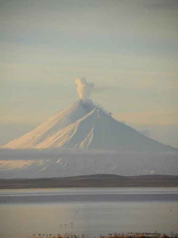
Pavlof, Alaska December 6, 20:28 UTC (Janine)
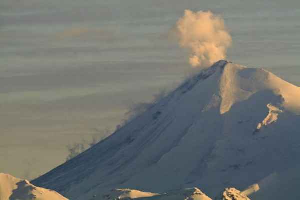
Photos of Pavlof volcano producing a small steam plume on Dec 5. Slightly elevated seismicity is being recorded and a increase in temperatures is measures at the summit due to the lave flow recently emplaced.
Asosan, Kyushu, Japan December 6, 15:52 UTC (Armand)
Ash explosions are still going on at the Aso volcan. JMA Webcam image at midnight Japan time
Sinabung, Indonesia December 6, 11:27 UTC (Armand)
'' @LeopoldAdam #SINABUNG 06/12 - 11:25am Pyroclastic flow glided 2.0km-South-Am:101 mm-166secs @karo_news pic.twitter.com/HzPWNnuE1e
— Info Karo (@karo_news) December 6, 2014
Hawaii Pahoa, Puʻu ʻŌʻō update December 6, 10:07 UTC (Armand)
Activity Summary: Kīlauea Volcano continues to erupt at its summit and within its East Rift Zone. A finger of lava has broken away from the west edge of the flow field below the crack system and continued to move to the north. The leading edge of this finger is approximately 3.9 km (2.4 miles) above the intersection of Pāhoa Village Road and Highway 130, near the Pahoa Marketplace. The summit is currently undergoing deflationary tilt after inflation on December 4.
June 27th Lava Flow Observations: HVO is monitoring a narrow finger of lava that has broken away from the west edge of the flow field below the crack system and that is moving to the north at rates of several hundred meters per day. Webcam imagery of smoke from burning vegetation at the flow front indicates that the flow continues to advance although at a reduced rate compared to the last several days. An overflight by Civil Defense on Friday morning located the leading edge as being approximately 3.9 km (2.4 mi) above the intersection of Pāhoa Village Road and Highway 130, near the Pahoa Marketplace. The flow has reached an area where several lines of steepest descent nearly converge due to flat topography. Until the flow passes this area of flat topography, the future flow path is uncertain.
Puʻu ʻŌʻō Observations: Tilt was essentially flat at Puʻu ʻŌʻō over the past 24 hours. All other monitoring data indicate no significant changes at Puʻu ʻŌʻō. Seismic tremor is low and steady, and webcams revealed no strong variations in the pattern of glow from degassing vents or the configuration of the crater floor. GPS-measured deformation across the cone has shown neither extension nor contraction since July. The most recent measurement of sulfur dioxide emissions from the East Rift Zone was about 250 tonnes per day on November 26, 2014.
Summit Observations: DI inflation changed to deflation at approximately midnight on December 5 . Inflationary tilt dominated on December 4 accumulating around 2 microradians over approximately 26 hours. Deflation in the summit over the past several hours has been accompanied by increased rates of long period earthquakes in the summit. Event rates of long period earthquakes was especially high between 6:00 AM and 6:50 AM. Deflationary tilt in the summit is often associated with increased rates of long period earthquakes. The summit lava lake showed the usual fluctuations associated with changes in spattering behavior, which are also manifested as variations in tremor amplitudes. Small amounts of particulate material were carried aloft by the plume. The average emission rate of sulfur dioxide was 4,300 tonnes/day for the week ending on December 2 (see caveat below).
Chiles and Cerro Negro, Ecuador/Colombia December 6, 00:34 UTC (Janine)
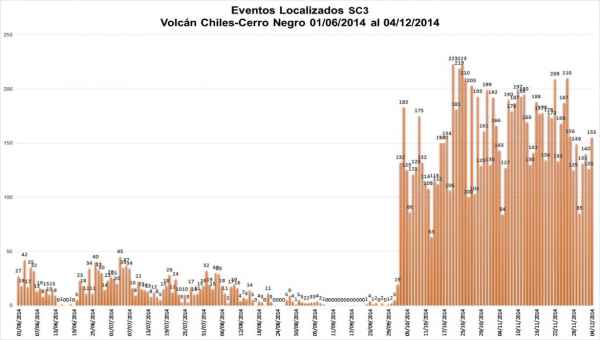
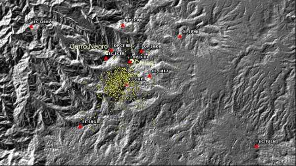
The Instituto Geofísico of Ecuador reports 19,916 earthquakes in the past week with an average of 2845 per day. The top image displays the number of seismic events for which the epicenter has been located, per day (maximum number on the x-axis is 250) with the distributions below. Five shallow earthquakes have been felt with depths less than 5 km.
Sinabung, Indonesia December 5, 11:27 UTC (Janine)
Explosion and small pyroclastic flow from the summit that left an incandescent area visible after flow emplacement and plume detachment.
Bárðarbunga, Iceland December 5, 14:17 UTC (Janine)
Beautiful video of the Holuhraun eruption fissure taken on December 4 (Thank you @CultureVolcan).
Bárðarbunga, Iceland update December 5, 11:10 UTC (Janine)
The Iceland Met Office reports that a decrease in seismic activity in the dyke intrusion continues. The eruption continues to be pulsatory in nature and the eruption intensity is slowly decreasing, although no end is in sight any time soon. The current lava being erupted is cooler and there is less thermal convection. These observations indicate that the upward flow of magma to Holuhraun is slowly decreasing.
Mayon, Philippines December 5, 10:35 UTC (Janine)
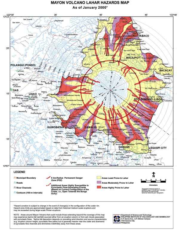
PHIVOLCS (Philippine Institute of Volcanology and Seismology) has posted a lahar advisory for the Mayon and Bulusan volcano areas. Heavy rains from Typhoon Ruby (Hagupit) may cause rain-induced lahars by eroding and remobilizing old pyroclastic flow deposits on the upper to middle slopes of the volcano. These lahars are a threat to downstream communities along the river channels with flooding, burial, and washout.
PHIVOLCS published the following Mayon volcano lahar hazards map in January 2000.
Reventador, Ecuador December 5, 10:21 UTC (Armand)
Great IR timelapse video from @CultureVolcan
Stromboli, Sicily, Italy update (Armand)
Spectacular video footage of Stromboli #volcano erupting in August #lavaflow #ballistics http://t.co/eMyxqofSQZ pic.twitter.com/k5EwYeHWKa
— Dr Janine Krippner (@janinekrippner) December 5, 2014
Popocatepetl, Mexico December 5, 1:56 UTC (Janine)
Mexico's National Center for Prevention of Disasters (CENAPRED) recorded a small ash column reaching 800 m high recorded on December 3. Video shows an explosive incandescent explosion that occurred that night at 21:54 after 5 minutes of harmonic tremor .
Volcano Activity for the week November 26 – December 2 (Armand)
Asosan | Kyushu (Japan)
JMA reported that on 25 November an eruption from Asosan’s Nakadake Crater occurred after increased tremor detected a few hours earlier. Ash plumes rose from the crater and produced ashfall to the E in Hanoi Aso (Kumamoto Region), Taketa (30 km NE, Oita Region), Gokase (25 km WSW, Miyazaki Region), and in Minamiaso (10 km SW, Kumamoto Region). Incandescence from the crater was recorded at night with webcams. On 26 November tephra was ejected 100 m above the crater rim and an ash plume rose 1 km. Tremor continued to be elevated. The eruption remained strong on 27 November, and ash plumes rose 1.5 km. During a field survey in an area S of Nakadake Crater volcanologists observed Strombolian activity in the crater, 7 cm of ash deposition, and fist-sized scoria. Ashfall was reported in a wide area to the W, mainly in Kumamoto (38 km WSW). According to a news article, flights in and out of Kumamoto airport were either cancelled or diverted. On 28 November ash plumes rose 1.5 km. The eruption continued through 30 November; ash plumes rose at most 1.5 km and incandescent material was ejected onto the crater rim. Inclement weather mostly prevented views of the crater during 1-2 December, but the small-scale eruption likely continued. The Alert Level remained at 2 (on a scale of 1-5).
Chirinkotan | Kuril Islands (Russia)
SVERT reported that since 21 November a thermal anomaly and increased gas-and-steam emissions at Chirinkotan were detected in satellite images. A thermal anomaly was detected on 25 November, and a diffuse steam-and-gas plume drifted 40 km SE on 27 November. Steam-and-gas emissions were again observed on 28 and 30 November. The Aviation Color Code was raised to Yellow.
Fogo | Cape Verde
According to news articles the eruption from Fogo's Pico cone inside the Cha Caldera continued during 26 November-2 December. In the morning of 30 November the eruption intensified; lava travelled at a rate of 20 m/hour and caused the closure of the only alternative route between the national park and Portela, the main town in the caldera. Authorities warned all residents in the caldera to evacuate. Lava destroyed almost 25 homes, a large area of agricultural land, the Parque Natural do Fogo museum, and other infrastructure. By 2 December there were two lava fronts. After about 24 hours of minimal advancement, the rate of advancement increased; lava overtook several more houses, a school, and a hotel.
Heard | Kerguelen Plateau
According to a NOAA National Environmental Satellite, Data, and Information Service (NESDIS) scientist, thermal anomalies seemingly on the E flank of Heard were detected in Visible Infrared Imaging Radiometer Suite (VIIRS) satellite images during 2-30 November. Dense cloud cover prevented views of the volcano during 1-2 December. MODIS (Moderate Resolution Imaging Spectroradiometer) images had detected thermal anomalies from September 2014 to 21 July 2014, and again on 16 November 2014, due to a persisting lava lake and possible lava flows.
Moyorodake [Medvezhia] | Iturup (Etorofu) Island (Japan/Russia)
On 27 November SVERT reported that during the previous 10 days a thermal anomaly and strengthening steam-and-gas activity were detected over Kudriavy, a stratovolcano of the Medvezhia volcanic complex. The size and intensity of the thermal anomaly increased considerably on 27 November. The Aviation Color Code was raised to Yellow. Diffuse steam-and-gas emissions were observed on 29 November.
Sinarka | Shiashkotan Island (Russia) | 48.875°N, 154.175°E | Elevation 934 m
SVERT reported that on 27 November satellite images of Sinarka showed steam-and-gas emissions drifting 50 km SE. Cloud cover obscured views on the other days during 24 November-1 December. The Aviation Color Code remained at Yellow.
Zhupanovsky | Eastern Kamchatka (Russia) | 53.589°N, 159.15°E | Elevation 2899 m
KVERT reported that strong explosions at Zhupanovsky were detected at 0206 on 23 November and 1214 on 25 November. Ash plumes rose to altitudes of 7-8 km (23,000-26,200 ft) a.s.l. and drifted 350 km E on 22 November and SE during 25-27 November. Satellite images detected a thermal anomaly over the volcano on 22, 25, and 27 November; cloud cover prevented views of the volcano on the other days. The Aviation Color Code remained at Orange.


