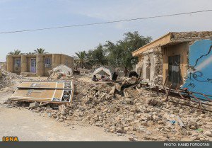
- Current Damage: 70 villages damaged to a large extent (30% to 90%), many houses destroyed, slight damage in Minab, 85km away.
- Current Economic Loss: Predicted to be in the region of > 5 million USD
Update 11:07am - A second death of a child has been registered although this has not been confirmed by a 2nd source.
Update 10:22am - The death was of a 13 month old child.
Update 9:11am - Much damage has occurred with over 70 villages damaged to within 30% and 90%. This goes along with the death and injuries.
Update 8:02am - Numerous power and water outages have also occurred.
Update 7:58am - The first fatality has been confirmed.
Update 7:50am - Information is slow to hand. Beyond the 20 injuries, 400 collapsed houses, and many damaged houses, not much else is known.
Update 6:59am - Also the town Minab was affected by the quake. At least 5 buildings there suffered minor damage.
Update 6:47am - New reports from Iran mentioning that at least 18 people were injured and only 2 of them were transferred to hospital. In earlier reports, there are more hospitalized people mentioned.
Update 6:31am - No new numbers of injuries or collapsed houses are known yet. The Red Crescent in now transferring tents, food and drinking water to the epicenter area.
UPDATE 5:10am - It is also rumored that one person was killed in the Hormozgan University. However, authorities have not confirmed the news.
UPDATE 4:50am - 9 aftershocks have occurred above M4. Injury toll up to 17 confirmed.

Damage from the area of Jask (it can be seen that the mud brick houses are no match for such earthquakes)
UPDATE 4:45am - USGS Shakemap is predicting now VIII shaking, which is exactly what we have seen!
UPDATE 4:45am - 11 villages have been damaged.
UPDATE 4:43am - The USGS has updated their hypocenter to the same as the Iran Seismological Center, reducing the depth to 15km, and a Mw6.0.
UPDATE 4:40am - 3 villages have reportedly been blocked off by landslides..
UPDATE 4:38am - The severity of damage in the 10 villages has increased as they are now being classified as destroyed. Each village generally has between 20 and 50 houses.
UPDATE 4:35am - 8 villages have heavy damage.
UPDATE 4:17am - There are 56 villages within a radius of 15 km arond epicenter. So far, damage and injuries were observed in 2 of 6 examined.
UPDATE 4:13am - Aftershocks are shaking the region at regular intervals with at least 3 strong M5 aftershocks felt so far.
UPDATE 4:11am - At least 10 villages have damage and destruction, and the injury toll of 11 is expected to rise. This area is very historical and old, and there are reports than many "historical villages" have been destroyed.
UPDATE 4:10am - Cracked houses have been reported in the city of Jask.
UPDATE 4:05am - 11 people have been injured. The rescue teams number has remained at 10 so far with a total of 50 people.
UPDATE 4:00am - 5 people have been injured at least, and many houses damaged.
UPDATE 3:35am - Many houses have collapsed according to eyewitness reports.
UPDATE 3:32am - A damaging M5.3 aftershock has occurred.
UPDATE 3:30am - Still no word on the number of casualties however 10 teams consisting of 50 search and rescue officers have been sent to the region with helicopters.
UPDATE 3:10am - There are unfortunately reports of casualties. Disaster response teams have been sent to the location around the epicenter. There will have been crews on site given the damaging M5 earthquake yesterday which destroyed 6 villages 30%-70%, i.e. with most buildings with significant damage. The shaking today will have been around 5-6 times that of yesterday.
UPDATE 3:00am - There are not many large settlements in the area, thus we hope that damage will be kept to a minimum. The houses in the area are however very vulnerable to earthquakes.
UPDATE 2:52am - Fatalities are expected via theoretical models.
UPDATE 2:52am - The earthquake has been given an Ml6.2 and 15km depth by the Iran Seismological Center. This struck Hormozgan in the area of Minab, where many houses were damaged in the past few days by a M5 earthquake. We hope that many people will have been out of their homes.
The initial depth calculation of USGS was 36km, however it could still be a shallower hypocenter once more information is gained. This is potentially very dangerous. The earthquake was felt in the United Arab Emirates.
Most important Earthquake Data:
Magnitude : 6.2
Local Time (conversion only below land) : 2013-05-11 06:38:11
GMT/UTC Time : 2013-05-11 02:08:11
Depth (Hypocenter) : 30 km
Depth and Magnitude updates in the list below.
Share your earthquake experience (I Have Felt It) with our readers.
Click on the "I Felt It" button behind the corresponding earthquake. Your earthquake experience is not only important for science, but also for people in the area as well as our global readership.

| SRC | Location | UTC Date/time | M | D | INFO | |
| EMSC | Southern Iran | May 11 23:27 | 3.7 | 17 | MAP I Felt It INFO | |
| USGS | Southern Iran | May 11 22:28 | 4.6 | 9 | MAP I Felt It | |
| EMSC | Southern Iran | May 11 22:28 | 4.6 | 45 | MAP I Felt It | |
| EMSC | Southern Iran | May 11 22:25 | 4.6 | 12 | MAP I Felt It INFO | |
| EMSC | Southeastern Iran | May 11 22:23 | 4.9 | 60 | MAP I Felt It | |
| USGS | Southern Iran | May 11 22:23 | 4.9 | 10 | MAP I Felt It | |
| GEOFON | Southern Iran | May 11 22:23 | 4.7 | 10 | MAP I Felt It | |
| GEOFON | Southern Iran | May 11 21:51 | 5.0 | 10 | MAP I Felt It | |
| USGS | Southern Iran | May 11 21:51 | 4.9 | 10 | MAP I Felt It | |
| EMSC | Southern Iran | May 11 21:51 | 4.9 | 40 | MAP I Felt It INFO | |
| EMSC | Southern Iran | May 11 21:00 | 3.5 | 20 | MAP I Felt It | |
| EMSC | Southern Iran | May 11 20:28 | 3.7 | 21 | MAP I Felt It INFO | |
| EMSC | Southern Iran | May 11 18:06 | 4.5 | 20 | MAP I Felt It INFO | |
| GEOFON | Southern Iran | May 11 18:06 | 4.7 | 10 | MAP I Felt It | |
| USGS | Southern Iran | May 11 18:06 | 4.7 | 23 | MAP I Felt It | |
| EMSC | Southern Iran | May 11 14:28 | 3.6 | 23 | MAP I Felt It | |
| GEOFON | Southern Iran | May 11 14:23 | 4.6 | 54 | MAP I Felt It INFO | |
| EMSC | Southern Iran | May 11 14:23 | 4.5 | 30 | MAP I Felt It INFO | |
| EMSC | Southern Iran | May 11 13:20 | 3.9 | 20 | MAP I Felt It | |
| EMSC | Southern Iran | May 11 12:55 | 3.6 | 22 | MAP I Felt It INFO | |
| EMSC | Southern Iran | May 11 10:25 | 4.3 | 20 | MAP I Felt It | |
| USGS | Southern Iran | May 11 10:25 | 4.3 | 27 | MAP I Felt It | |
| GEOFON | Southern Iran | May 11 10:25 | 4.7 | 10 | MAP I Felt It INFO | |
| EMSC | Southern Iran | May 11 10:03 | 4.6 | 20 | MAP I Felt It INFO | |
| GEOFON | Southern Iran | May 11 10:03 | 4.8 | 10 | MAP I Felt It | |
| USGS | Southern Iran | May 11 10:03 | 4.6 | 24 | MAP I Felt It | |
| EMSC | Southern Iran | May 11 08:42 | 5.0 | 30 | MAP I Felt It | |
| GEOFON | Southern Iran | May 11 08:42 | 5.1 | 10 | MAP I Felt It | |
| USGS | Southern Iran | May 11 08:42 | 5.0 | 22 | MAP I Felt It | |
| EMSC | Southern Iran | May 11 08:38 | 4.0 | 20 | MAP I Felt It | |
| EMSC | Southern Iran | May 11 07:58 | 4.2 | 15 | MAP I Felt It INFO | |
| USGS | Southeastern Iran | May 11 05:59 | 4.3 | 10 | MAP I Felt It INFO | |
| EMSC | Southern Iran | May 11 05:59 | 4.3 | 20 | MAP I Felt It | |
| USGS | Southern Iran | May 11 05:45 | 4.3 | 24 | MAP I Felt It INFO | |
| EMSC | Southern Iran | May 11 05:45 | 4.0 | 20 | MAP I Felt It INFO | |
| USGS | Southern Iran | May 11 05:34 | 4.4 | 25 | MAP I Felt It | |
| EMSC | Southern Iran | May 11 05:21 | 3.9 | 21 | MAP I Felt It | |
| EMSC | Southern Iran | May 11 04:53 | 3.8 | 17 | MAP I Felt It | |
| EMSC | Southern Iran | May 11 04:51 | 3.8 | 28 | MAP I Felt It INFO | |
| USGS | Southern Iran | May 11 04:09 | 4.7 | 25 | MAP I Felt It | |
| GEOFON | Southern Iran | May 11 04:09 | 4.8 | 10 | MAP I Felt It INFO | |
| USGS | Southern Iran | May 11 03:58 | 4.4 | 30 | MAP I Felt It | |
| EMSC | Southern Iran | May 11 03:58 | 4.4 | 20 | MAP I Felt It | |
| GEOFON | Southern Iran | May 11 03:58 | 4.6 | 10 | MAP I Felt It | |
| USGS | Southern Iran | May 11 03:41 | 5.0 | 30 | MAP I Felt It | |
| GEOFON | Southern Iran | May 11 03:41 | 5.1 | 10 | MAP I Felt It | |
| EMSC | Southeastern Iran | May 11 03:41 | 5.0 | 20 | MAP I Felt It INFO | |
| USGS | Southern Iran | May 11 03:17 | 4.7 | 25 | MAP I Felt It | |
| GEOFON | Southern Iran | May 11 03:17 | 5.0 | 10 | MAP I Felt It | |
| EMSC | Southeastern Iran | May 11 03:10 | 5.4 | 20 | MAP I Felt It | |
| GEOFON | Southern Iran | May 11 03:09 | 5.5 | 10 | MAP I Felt It | |
| USGS | Southern Iran | May 11 03:09 | 5.3 | 27 | MAP I Felt It | |
| USGS | Southern Iran | May 11 03:03 | 4.8 | 23 | MAP I Felt It | |
| EMSC | Southern Iran | May 11 03:03 | 4.8 | 20 | MAP I Felt It | |
| GEOFON | Southern Iran | May 11 03:03 | 4.9 | 33 | MAP I Felt It | |
| USGS | Southern Iran | May 11 02:50 | 4.6 | 25 | MAP I Felt It INFO | |
| GEOFON | Southern Iran | May 11 02:50 | 4.7 | 10 | MAP I Felt It | |
| EMSC | Southern Iran | May 11 02:50 | 4.6 | 20 | MAP I Felt It | |
| EMSC | Southern Iran | May 11 02:45 | 4.1 | 16 | MAP I Felt It | |
| USGS | Southern Iran | May 11 02:32 | 4.5 | 26 | MAP I Felt It | |
| EMSC | Southern Iran | May 11 02:32 | 4.5 | 20 | MAP I Felt It | |
| GEOFON | Southern Iran | May 11 02:32 | 4.7 | 10 | MAP I Felt It INFO | |
| EMSC | Southern Iran | May 11 02:29 | 4.6 | 20 | MAP I Felt It | |
| USGS | Southern Iran | May 11 02:29 | 4.6 | 35 | MAP I Felt It | |
| GEOFON | Southern Iran | May 11 02:29 | 4.8 | 10 | MAP I Felt It | |
| USGS | Southern Iran | May 11 02:08 | 6.0 | 14 | MAP I Felt It | |
| GEOFON | Southern Iran | May 11 02:08 | 6.2 | 10 | MAP I Felt It | |
| EMSC | Southern Iran | May 11 02:08 | 6.2 | 30 | MAP I Felt It INFO | |
|
|
||||||
| Fast EARTHQUAKE and TSUNAMI TWEETS @ your MAGNITUDE choice | |||
 |
 |
 |
 |
| Regional Twitter Accounts CHILI - CANADA - BRITISH COLUMBIA - CALIFORNIA - OREGON - WASHINGTON - HAWAII - TEXAS - OKLAHOMA | |||
Other earlier earthquakes in the greater epicenter area (since 1900)
Strongest earthquakes within a 150 km radius from this earthquake (max. 60)