This is Part 56 of the El Hierro Volcano eruption report
CLICK HERE TO READ THE LATEST NEWS
You may follow also Facebook Volcano Page – Google+ Volcanoes – Twitter : @VolcanoReport
With the collaboration of Joke Volta, an El Hierro resident and Julio del Castillo Vivero, photographer.
Read also : (28/7 – early 09) – (25/09 – 10/10) - (11/10 – 13/10) - (14/10 – 17-10) - (18/10 – 21/10) - (22/10 – 26/10 ) – (27/10 – 31/10 ) – (01/11 – 03/11 ) - (04/11 – 06/11 ) – (07/11 – 08/11) – (09/11- 11/11) – (12/11 – 15/11) – (16/11 – 19/11) – (20/11 – 23/11) – (24/11 – 27/11) – (28/11 – 02/12) - (03/12 – 07/12) – (08/12 – 11/12) – (12/12 – 15/12) – (16/12 – 18/12) – (19/12 – 25/12) – (26/12 – 31/12) – (01/01 – 03/01) – (04/01 – 07/01) – (08/01 – 13/01) – (14/01 – 19/01) - (20/01 – 25/01) - (26/01 – 30/01) – (31/01 – 04/02) – (05/02 – 10/02) – (11/02 – 16/02) – (17/02 – 23/02) – (24/02 –29/02) – (1/03 – 10/03) – (11/03 – 18/03) – (19/03 – 23/03) – (24/03 – 28/03) - (29/03 – 03/04) – (04/04 – 10/04) – (11/04 – 21/04) – (22/04 – 30/04) – (01/05 – 10/05) – (11/05 – 31/05) – (01/06 – 14/06) – (15/06 – 24/06) – (25/06 – 26/06) – Part 47 (27/06 – 28/06) – Part 48 (29/06 – 01/07) – Part 49 (02/07 – 06/07) – Part 50 (07/07 – 31/07) – Part 51 (01/08 – 31/08) – Part 52 (01/09 – 11/09) - Part 53 (12/09 – 30/09) - Part 54 (01/10 – 15/12) - Part 55 (16/12 – 16/03)
Useful links : @VolcanoReport – El Hierro Picasa Photo Album
Part 56 (16/03 - 26/03) -
2013-03-26 23:30 UTC
- We can confirm what we wrote an hour ago. The epicenters are gradually moving towards the island again.
- 195 earthquakes were listed by IGN so far today.
- 13 earthquakes had a Magnitude of M3 or more. The strongest earthquake was a M3.6.
2013-03-26 22:30 UTC
- A series of relatively strong earthquakes have been felt by some of the inhabitants of El Hierro starting at 22:00. It seems that the last earthquakes are moving slowly south and towards the island.
-Listed Earthquakes by IGN:
22:01 - M3.0 - Depth 16 km.
22:07 - M3.1 - Depth 15 km.
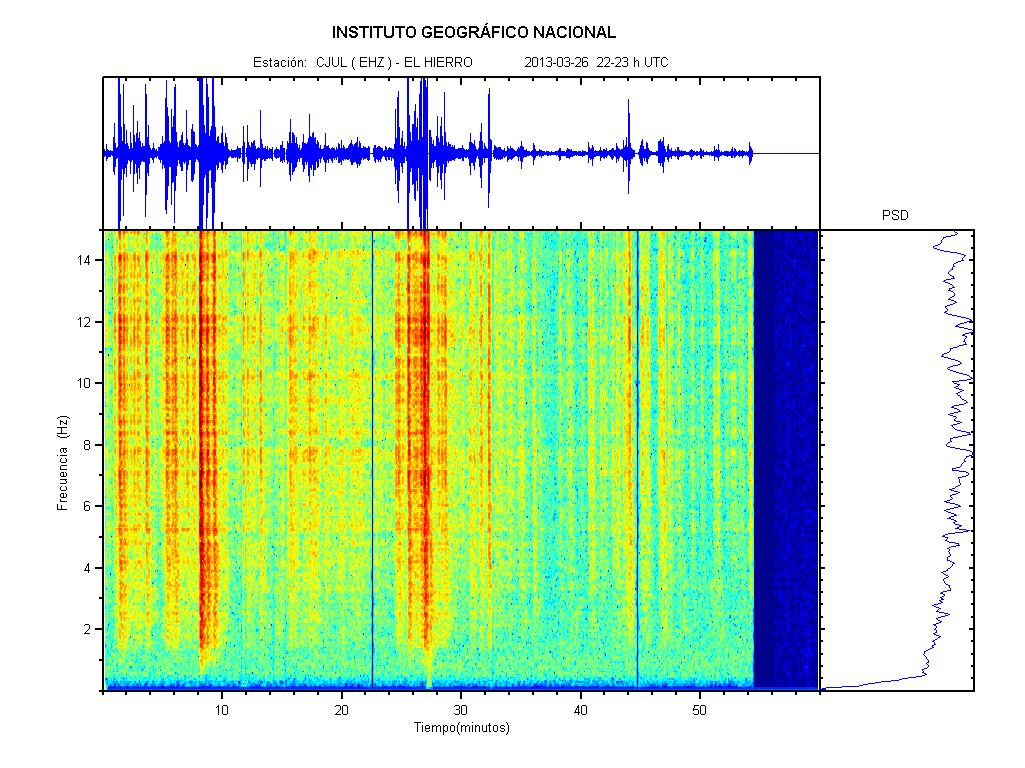
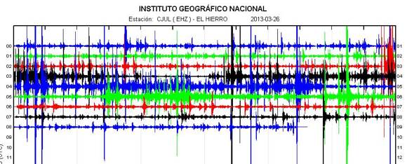
- Tremor graph for 22-23 UTC shows this shacking.
2013-03-26 19:45 UTC
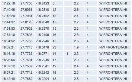
Herreños continue feeling some of the earthquakes, Joke felt the 18:16 Magnitude 3.3 earthquake as the windows vibrated.
More islanders described feelings of constant vibrations for a few seconds in intervals lasting for some minutes. There might not be M4 earthquakes, but there are many earthquakes shaking the island today.
- 170 earthquakes listed by IGN so far today
- After yesterday, it almost looks like the activity is over, but the contrary is the case. Below a small group of the last earthquakes who are all above M2. The M3.3 earthquake was also felt on the island
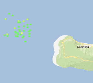
- As the seismic action is occurring approx. 10 km out in the Ocean, the earthquakes are less visualized on the map below.
- Hypocenters are varying a lot today
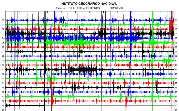
- The strongest earthquakes are also visible on the seismograms from La Palma and La Gomera
2013-03-26 14:00 UTC
- This image taken yesterday by residents of El Pinar shows rockfall close the lighthouse of Orchilla. Credit of image to Volcanes de Canarias.
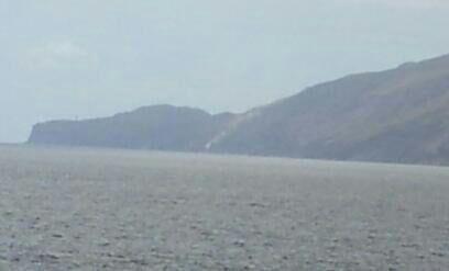
Rockfall near Faro de Orchilla. Credit: Volcanes de Canarias
2013-03-26 13:30 UTC
- PEVOLCA has decided to keep alert level GREEN after their meeting today. They argue there is no significant risk to the population to take any extraordinary measures.
- Also, according to them, there is a 75% chance of a M4.3+ earthquake .

Members of PEVOLCA at the meeting today.
2013-03-26 11:07 UTC
- We do see a clear double activity field. First of all shallow earthquakes in an area further away from the island and deeper quakes in the area in between 7 and 10 km from the western shoreline.
- Activity weakening but as we know from the last couple of days, this does not necessary mean the end of the crisis.
2013-03-26 09:38 UTC
Only 16 M2.5 or more earthquakes in our daily earthquake list so far today does not mean that everything came to a standstill. The seismic crisis is continuing also without the very powerful earthquakes. Some statistics :
- 224 earthquakes yesterday
- 43 of these 224 earthquakes were M3 or stronger, the strongest one being a M4.1 felt as a MMI III (weak shaking)
- 74 earthquakes listed by IGN so far today and thats still an active volcano beneath the island even when the intensity is less than yesterday. 5 earthquakes were M3 or higher with the strongest one being a M3.6. The 74 earthquakes do include also Magnitudes below M2.0 which indicates an overall weaker activity than yesterday.
- Hypocenter depths are considerably shallower than yesterday, many of them in the 10 km depth layer.
- Distance from the epicenter area to the western unpopulated coast still considerable
- Deformation is still going on at a high rate both Upward and Eastward
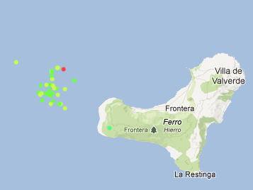
Epicenters since midnight today - image courtesy AVCAN Canary Islands
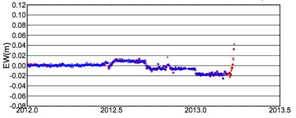
Deformation increase to the East - image courtesy University Nagoya, Japan
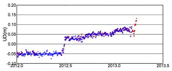
Upward deformation - image courtesy University Nagoya, Japan
2013-03-25 22:54 UTC
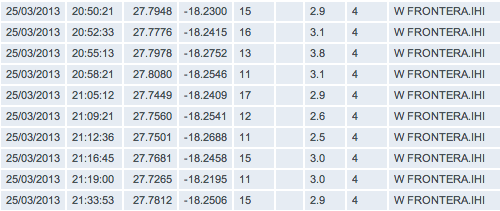
- Only a limited change to report as we are in a period with weaker earthquakes. The hypocenters below are however a lot shallower than during the previous hours, now at 11 to 15 km (see last 10 earthquakes of the list below). Epicenters still far out of the coast.
- 204 earthquakes listed by IGN
2013-03-25 21:07 UTC
- A new set of stronger earthquakes has started at 20:55 UTC. They are not yet listed but we expect them to be in the M3 to M3.5 range.
- Badly predicted as it was finally M3.8 at a depth of 13 km. Epicenter approx. 10 km out in the Ocean.
- So far 40 earthquakes of M3.0 or more today
- 193 earthquakes listed by IGN so far today BUT in reality there are hundreds of earthquakes, even more of them below M2 than above it.
2013-03-25 18:45 UTC
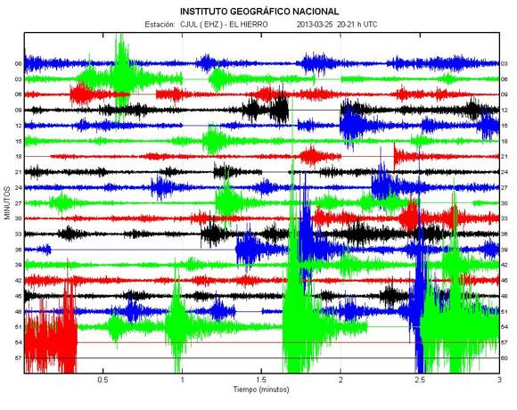
- A period of weaker quakes has followed the very strong seismicity.
2013-03-25 16:32 UTC
- Activity somewhat calming down now.
- We have cut off a big chunk of this page and have archived it in Part 55 of the El Hierro volcano story. Link to this part at the bottom of this page. (thank you Colin for mentioning). If the activity continues like the last couple of days, we will be reducing again.
2013-03-25 16:32 UTC
- The very strong deformation of the island may create some stress in buildings and infrastructure nearest the seismic activity
2013-03-25 16:13 UTC
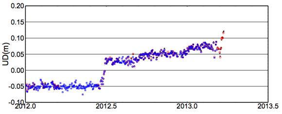
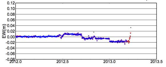
- The University of Nagoya and Involcan have changed the scale of the upwards deformation which enables us to watch the deformation again. As could be expected a further very strong upwards deformation at the Sabinosa GPS station. The station is also pushed strongly to the East (lower image)
2013-03-25 15:44 UTC
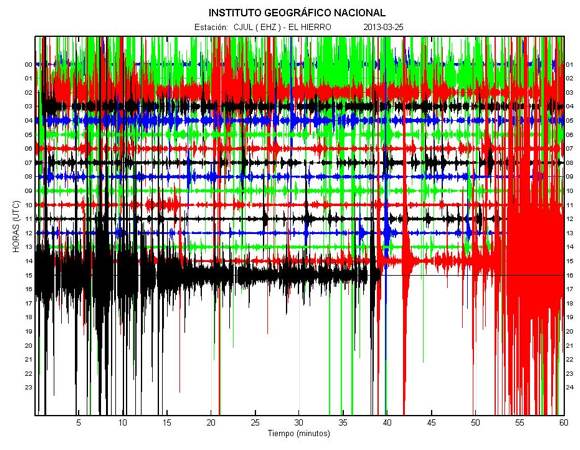
- People at the island are talking about a lot of vibrations and rumble, but less than when the M4.1 struck
- People at El Hierro can sleep on both ears (proverb in my country) as PEVOLCA will meet tomorrow. We do not see however a reason to be scary at the island unless for even stronger earthquakes who can trigger rockslides at the steep cliffs of the western part of the island.
- There is NO continuous HT at this moment, which is needed if a vent would open on the seabed.
2013-03-25 15:25 UTC
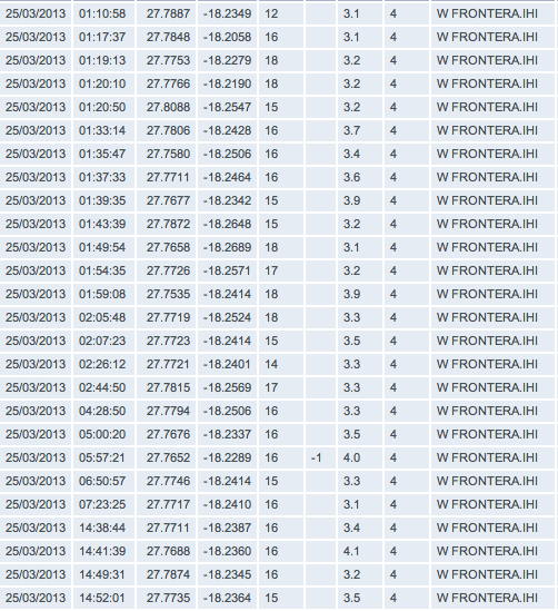
- Below only a snapshot of today's activity (the strongest ones), but a lot of earthquakes have to be added to this list (the last 30 minutes).
2013-03-25 15:16 UTC
- This is without any doubt one of the most powerful earthquake sessions since the start of the eruptive process at El Hierro. Readers will be surprised about the number of very powerful events when they are listed by IGN.
Luckily for El Hierro everything is happening out in the sea at a depth of +1500 meter. A volcano has however NO guarantee at all that the action will stay in that area. The same happened during the eruption in 2011 when the magma vent was located in a totally different area than the earthquake epicenters. This was however an exception.
2013-03-25 15:13 UTC
- Extremely strong tremor at this moment with very strong earthquakes (volcanic of course). If the tremor is continuing like this, IGN will have to post a report soon.
2013-03-25 15:06 UTC
- The strong quakes are currently generating rockfall near Sabinosa ! (based ona report from a person living there)
2013-03-25 15:03 UTC
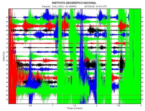
- A few minutes ago we had the strongest earthquake from this crisis, a M4.1 at 16 km depth (same area out in the sea). The image below shows this earthquake on the seismogram and not a piece of art :). Just before the 4.1 one, we had a M3.4 one, also at a depth of 16 km.
2013-03-25 11:59 UTC
Joke Volta commented a few things :
A thing that I do not like, is all this intrusion on different depth(sills)The southern part of the island must be a “gruyere” meanwhile…but..el Hierro still offers different things: Do you want to feel quakes? well, in The Golfo Bay and in the south you can get this.If you do not want to feel this activity, you can stay in the northern part of the island, the volcanic older part actually, and…you allmost do not feel the quakes…:-)
2013-03-25 11:35 UTC
- Too soon to say that it is over, but the slowdown of earthquake frequency and strength is very visible on the graphs (IGN is listing earthquake Magnitudes less than 2 again). Hypocenter depth is wobbling a lot (12 to 20 km).

2013-03-25 11:10 UTC
- PEVOLCA, the committee of authorities and scientists, will meet tomorrow to discuss the current crisis. They are saying at the same time that there is NO risk at all at present for the population but they will look also into possible scenarios which can develop in the near future. We agree fully with their analysis based on the present data.
2013-03-25 10:19 UTC
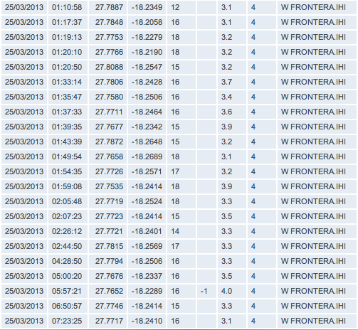
- We have counted 22 M3 or more earthquakes (see list below). The strongest activity was in between 01:00 AM and 03:00 AM
2013-03-25 08:55 UTC
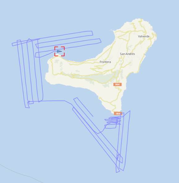
- The unconfirmed Ramon Margalef reports cruising to the west of the island have been confirmed by the website "vesselfinder.com". ER reader Sissel did send us a map with the cruising traject. The zigzagging lines are showing clearly the bathymetry scans of the different sectors. Lets hope that the reports from the ship will not be kept secret until the following international congress (were were pleasantly surprised yesterday by the swift reporting of the degassing vents in the 2011 eruption area)
2013-03-25 08:26 UTC
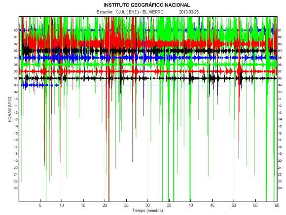
- Yesterday ended with 159 earthquakes listed by IGN. The real number (including the weak and micro quakes) must run into the hundreds!
- 73 earthquakes listed by IGN today including a lot of M3+ earthquakes and even a M4.0 earthquake which was felt all over the island.
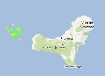
- The current seismic crisis is getting into a new phase with a lot of shallower earthquakes. The magma intrusion seems to have found his way up to 11 to 13 km, a huge difference compared to yesterday (16 to 17 km).
- From now on we will have to watch satellite images to find out whether the ocean is coloring or not. Why ? Strong earthquakes (in the M3.5 to M4.0 range) combined with a depth of 10 km led to the first Las Calmas eruption vent. While the Las Calmas location was very visible to many, the current location of the epicenters is too far out in the ocean. No villages on that side of the island.
- Unconfirmed reports are mentioning that the Oceanographic vessel Ramon Margalef is on its way to the west of the island (as we expected yesterday).
- Deformation is hard to tell as we have reached the limit of the graph of the University of Nagoya Sabinosa GPS station.
- The strongest earthquakes are somewhat eased at the time of writing.
Earthquake-Report.com likes to thank multiple donors Jon (Dee Why, Australia), Sissel (Holland), Jouni (Espoo, Finland), Victoria (Rincon, Georgia), Kirsten (Helsingborg, Sweden), Nils (Alversund, Norway), Richard (Bolton, UK), Jan (Copenhagen, Denmark), Andrea (Wolmirstedt, Germany), Fred (Farmborough, UK) and Tom (Stege, Denmark) for their kind donations.
2013-03-24 22:00 UTC
- 148 earthquakes until the time of writing this update
- no change in important data (same depth and same epicenter area).
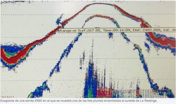
- The Oceanographic vessel Ramon Margalef has scanned the La Restinga vent area. They found 3 spots which were degassing (see image below who shows 1 degassing spot - plume at the left side). This gas emission has probably nothing to do with the current crisis as the same degassing was also reported many months after the end of the eruption. It was captured on video by the ROVs of a number of expeditions. The ship has not cruised the current earthquake area as this mission was planned a long time before the current crisis. There will be a total of 3 such missions. If the current crisis continues, we suppose that the plans may be altered.
- INVOLCAN is sending in a team to El Hierro tomorrow. they will reinforce measuring systems and will also be measuring CO2
2013-03-24 18:20 UTC
- 129 earthquakes listed so far today.
- 3 earthquakes M3+, an M3.1, an M3.5 and a M3.6, were all felt by (some) people at El Hierro, which is normal at these magnitudes. No fundamental change in depth and hypocenter location. The current activity can lead to even stronger earthquakes.
- We want to reiterate to our readers from the other side of the Atlantic Ocean NOT TO BELIEVE so called imminent Tsunami danger alerts spread in articles and videos. There is NO reason whatsoever to believe that there is a high risk for a dramatic event.
2013-03-24 13:24 UTC
- Believe it or not, but already 104 M2+ volcanic earthquakes below El Hierro so far today, that's more activity than yesterday at this time of the day. Yesterday ended with 165 volcanic earthquakes.
- Hypocenters in the 15 to 17 km layer
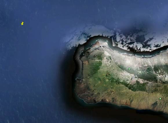
- When pointing the center of the current action (last 15 earthquakes) on a Google earth map, we arrive at a seabed depth of 1800 meters
2013-03-24 08:48 UTC
- Our daily M2.5 earthquake list looks like only the Canary Islands exist today.
- The scientists who said a couple of days ago that this crisis wont end in an eruption as the strength was not enough to reach the seabed, may start to write a second opinion. The crisis goes on and is a lot stronger than the last episode. Some more facts :
- 62 M2+ earthquakes so far today = hundreds of volcanic earthquakes of we would also count the weaker ones (which IGN did at the start in 2011)
- Hypocenter or focal depths (breaking point in the layers below the island) 16 to 17 km depth (4 to 5 km deeper than yesterday).
- The epicenter locations have shifted a little to the West (main reason for the deeper hypocenters).
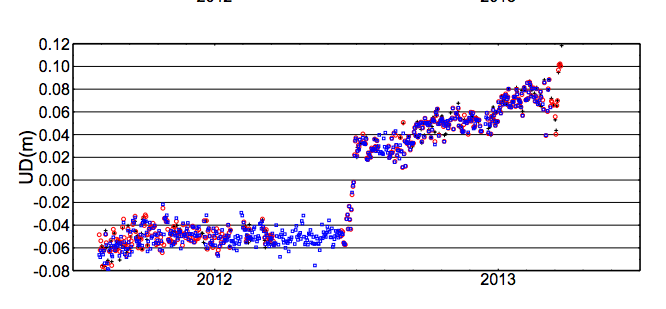
- Deformation statistics are very spectacular as the Sabinosa GPS has been forced upwards with 2 cm the last 24 hours (see image University of Nagoya below ). The same GPS was also forced 1 cm to the East. North/South remained the same.
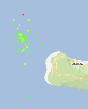
Epicenter locations so far today - image courtesy AVCAN
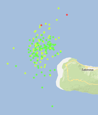
Epicenter locations yesterday
2013-03-23 23:55 UTC
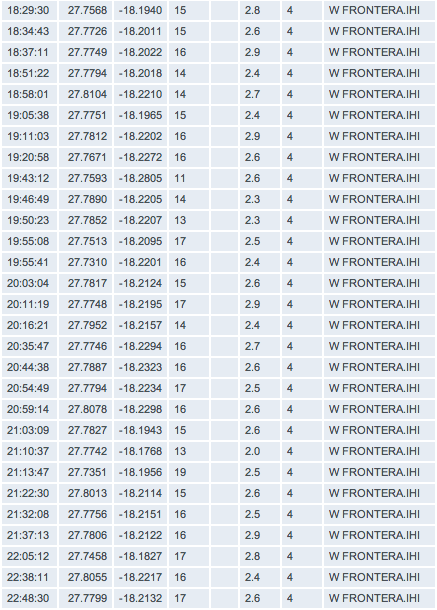
- Almost midnight UTC and the counter shows 164 volcanic earthquakes, the most active day of the current crisis
- The latest 20 listed earthquakes are gradually deeper again, mainly by the migration of the epicenters towards the south (lighthouse area). Focal depth of hypocenters is now ranging in between 16 en 17 km.
- The frequency and strength of the earthquakes has somewhat weakened the last couple of hours, but remains still strong
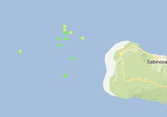
Epicenters of the last set of earthquakes - Image courtesy AVCAN
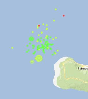
Epicenters of the last 12 hours
2013-03-23 19:15 UTC
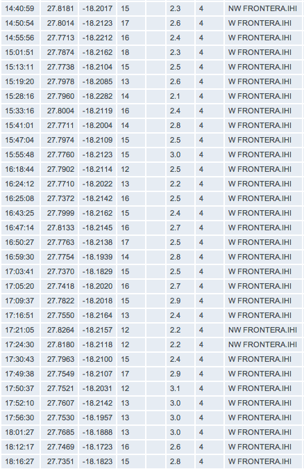
- 134 earthquakes so far today (strongest activity since the start of this seismic crisis)
- Hypocenters gradually shallower (12 to 14 km layer) which indicates that the magma is reaching cracks in higher levels. Too far out in the sea to generate a Surtseyan eruption if a new vent would emerge (seabed depth 1000 to 1300 m)
2013-03-23 15:32 UTC
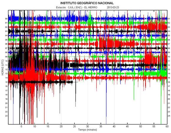
- Another strong M3.5 earthquake
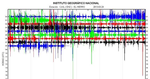
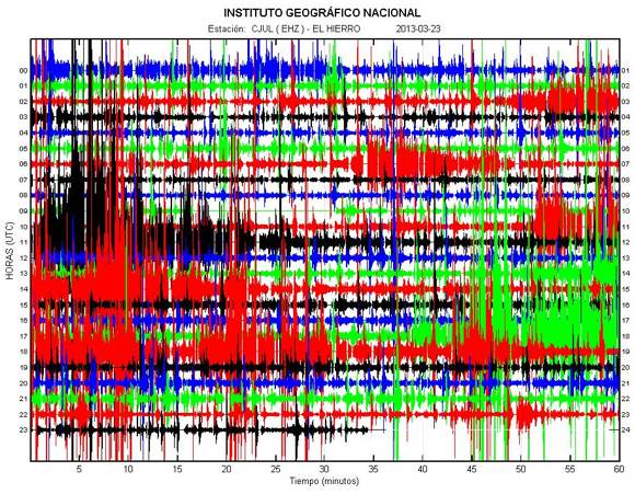
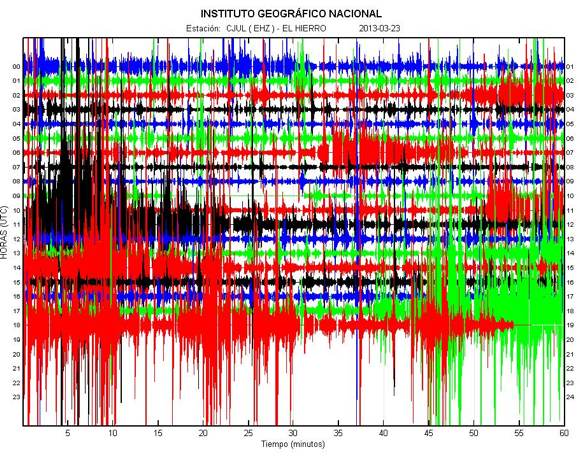
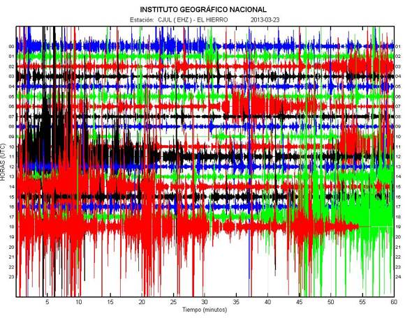
- If confirmed, there might be a tendency of shallower earthquakes in the 12 to 14 km layers. The graph below is the El Julan seismograph
- Our current reporting is getting more spectacular every hour 🙂
2013-03-23 14:16 UTC
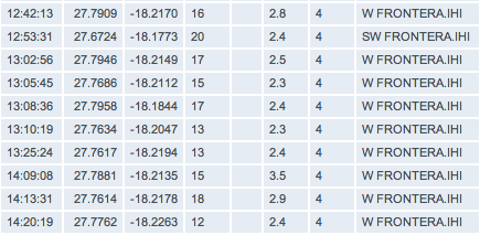
- Continuing strong seismicity. Until now already 7 M3+ earthquakes today.

2013-03-23 11:35 UTC
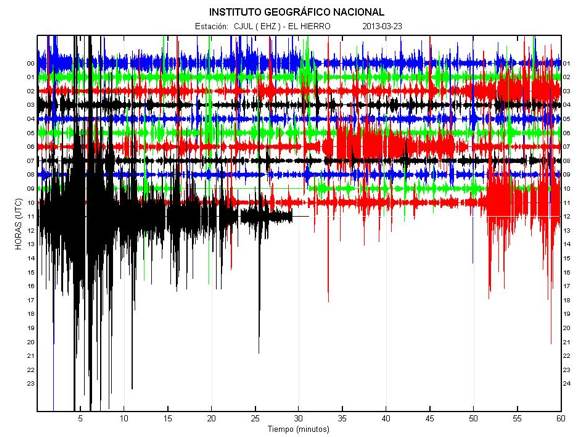
- The cjul graph below (El Julan seismograph) shows some strong seismic activity (EMSC reported a M3.5 earthquake a little while ago). Our readers can eventually open another tab with our M2.5+ earthquakes list, showing all the stronger El Hierro earthquakes too. Click here for this automatically refreshing list. The epicenter is however out in the sea, nobody has to worry about any dangerous action.
The present activity shows that the magma feed is continuing.
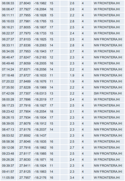
- 71 earthquakes listed by IGN at the time of writing (see earthquakes since our latest update in the image below)
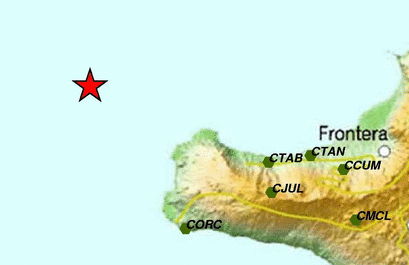
Epicenter of the above strong M3.4 earthquake
2013-03-23 07:55 UTC
- The seismic activity continued overnight.
- 93 earthquakes yesterday
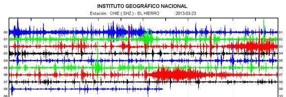
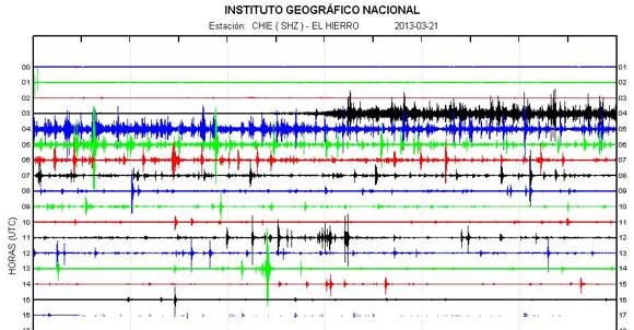
- 41 IGN listed volcanic earthquakes so far today. IGN is only listing the M2.0 or stronger earthquakes. The real number can however run into the hundreds. At the beginning of the El Hierro crisis IGN was listing almost everything measurable, this led to huge lists. Since last year a new policy was adopted and the general public only gets some filtered information. A pity. There is however a way to find out how many there are in reality. Look at the CHIE graph and count the vertical peaks. We did the test and counted at least 173 earthquakes in between 03:00 and 04:00 this morning.
- Hypocenter depths unchanged at 15 to 17 km, with little exceptions
- Epicenter locations are today a little more out in the sea than yesterday. The Sea bed where the most earthquakes are centered is at a depth of 1300 m, in other words it is impossible to have surface activity even with an eruption at this location because of the very high water column pressure.
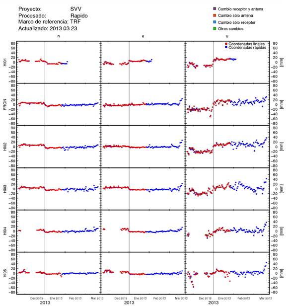
- Vertical deformation is still increasing (we reiterate our request to both IGN and Prof. Sagyia for a more precise date scale for the deformation images)
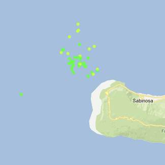
Epicenter location image courtesy AVCAN Canary Islands
2013-03-22 23:55 UTC
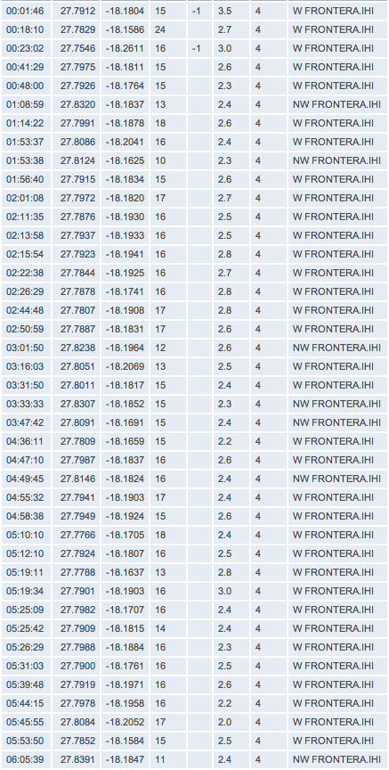
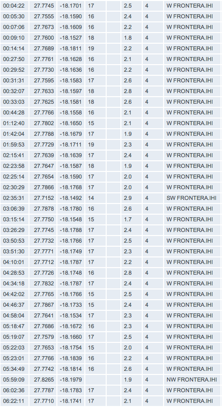
- The seismic activity continues at moderate strenth with a lot of volcanic earthquakes in the same area than the last couple of days. Most of the listed earthquakes are M2.0 or stronger.
2013-03-22 16:25 UTC
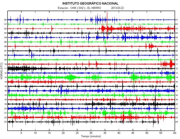
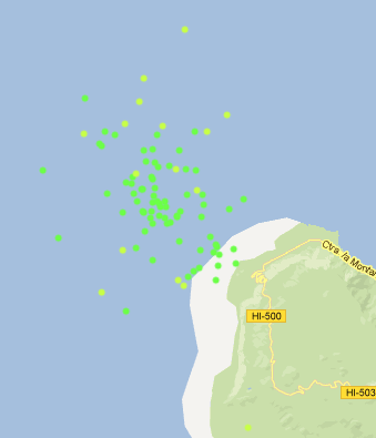
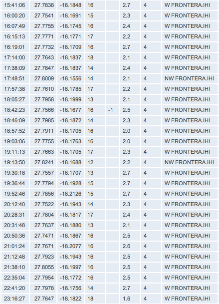
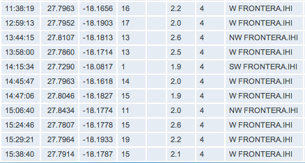
- Especially for our impatient readers, we want to stress that 1 or 2 shallow earthquakes do not change a lot. The 1 km depth quake is an isolated quake under the island and not linked to the current activity. We do see however a gradual shift to a somewhat shallower layer at a depth of 13 to 15 km. We continue to follow up the situation and do welcome your comments if some major changes are spotted.
2013-03-22 12:04 UTC
- 13 more earthquake listed by IGN since our latest updates. We repeat that the real number of volcanic earthquakes is far higher than those listed as IGN only picks up the stronger ones.
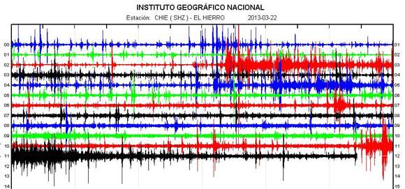
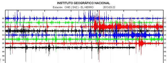
- Tremor is still very strong at intervals.
2013-03-22 07:54 UTC
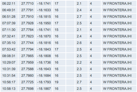
- 117 earthquakes yesterday. The strong M3.8 earthquake was felt as a light shaking (MMI IV) by the people living closest to the epicenter. The hypocenter depth did become slightly shallower and is located since yesterday at the 15 to 17 km layer. We want to mention however that the dept is shallower than most of the stronger earthquakes during the last crisis in the lighthouse area.
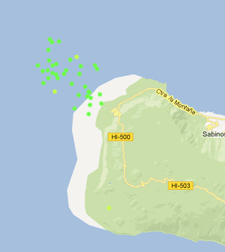
- 38 earthquakes so far today, still at the same depth. The most powerful earthquake since midnight is a M2.9 at a depth of 14 km.
- The epicenters are concentrated at the unpopulated northern shore of the western tip of the island (see Avcan map below).
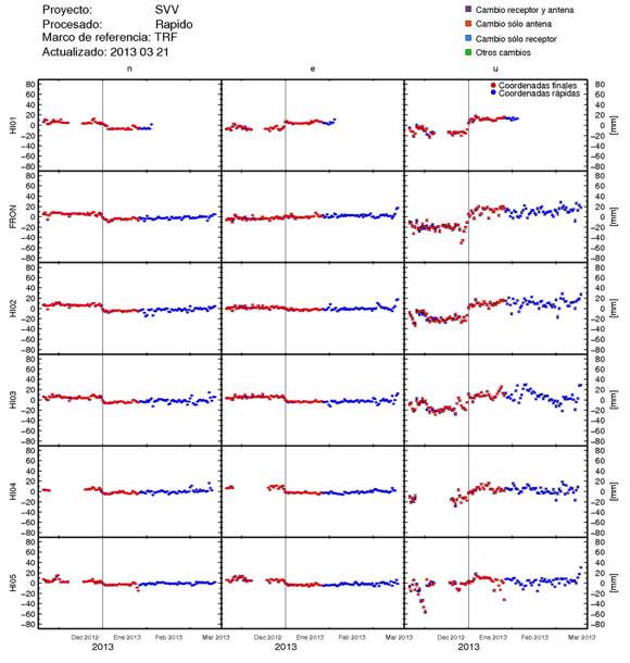
- The upward deformation continues to rise. The last black point is the ultra-rapid deformation data, not final but mostly very close to the final value. Since the middle of 2012, the island has been lifted by 15 cm!
- Tremor remains strong all night.
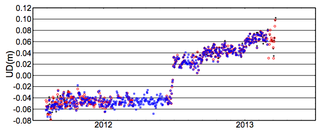
Image courtesy GPS network from the university of Nagoya, Japan and Involcan
2013-03-21 23:17 UTC
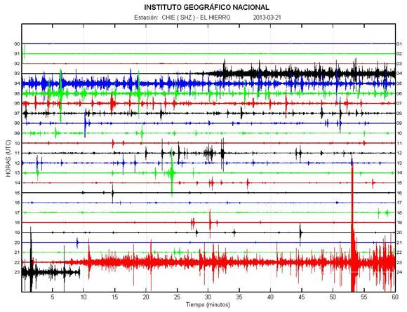
- Another reactivation of the process at 22:10 UTC followed by the most powerful earthquake since the beginning of the current crisis. The IGN list is however not reachable at this moment. EMSC reports that this earthquake had a Magnitude of 3.8 at a depth of 18 km. It was of course felt by the people on the island. The epicenter of this earthquake was below the western part of the island.
- Such strong earthquakes now and then are very normal for the current process. This means that the magma still looks for a way to go higher. The theory that this crisis was almost over (as mentioned by some scientists) may have to be revised. Similar strength earthquakes are a possibility for the coming hours and days. The still extending deformation is another sign that it is not yet over.
- The oceanographic vessel Ramon Margalef is currently at Tenerife and will shortly cruise to the El Hierro waters with scientists aboard. This was planned before (3 missions) and has nothing to do with the current crisis. All the current activity is still deep below the island.
2013-03-21 17:13 UTC
- Seismic activity continues further although the last couple of hours with less frequency.
- 98 earthquakes so far today
- Maximum Magnitude M2.6.
- Average depth still in the same layer.
- Some earthquakes are listed with very shallow depths from 2 km. It is very unlikely that these are magma intrusion earthquakes, more likely stress quakes triggered by the deformation of the island. There is however no absolute certainty about this.
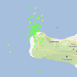
Epicenter image courtesy AVCAN Canary Islands
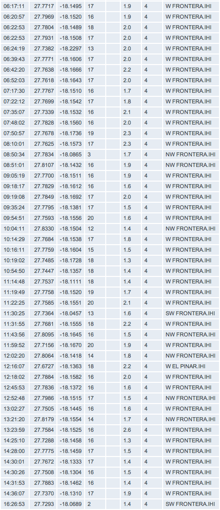
2013-03-21 07:48 UTC
- Yesterday ended with 24 volcanic earthquakes in total
- The image below shows a new (short) period with volcanic earthquakes. The strong tremor at the start tells us that the magma reached other channels. The hypocenter depth remained however in the 16 to 18 km layer.
- The 3th map shows the deformation of the island and as could be expected with such a crisis, the activity is also confirmed in the deformation which is a mainly eastern and upwards (center and right parts of the graph)
- Another map shows the location of the epicenters of today's earthquakes. No real change vs yesterday and 2 days ago.
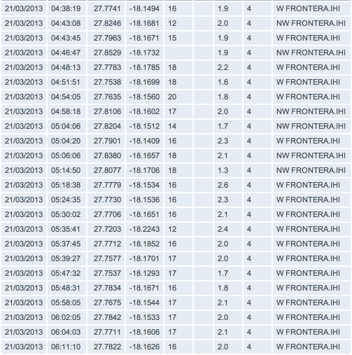

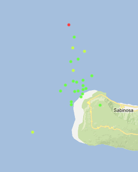
Epicenter map courtesy AVCAN Canary Islands
2013-03-20 11:20 UTC
- No change in the pattern today, only 22 earthquakes today. A revival of the crisis would surprise us although not impossible of course. The seismic crisis are behaving like paroxysms (short-lived strong action).
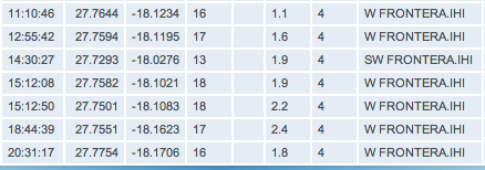
2013-03-20 11:20 UTC
- First of all our apologies for the long "outage" (almost 12 hours), due to a power failure in the Dreamhost Data Center.
- Yesterday IGN has listed 114 earthquakes, the last part of the list a little weaker than the first part. The depth remained at 16-18 km (no change vs the day before).
- ONLY 15 earthquakes today and all of them are considerably weaker (only 1 +M2). This crisis looks to be very short-lived.
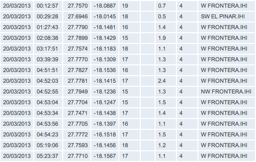
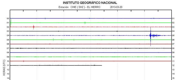
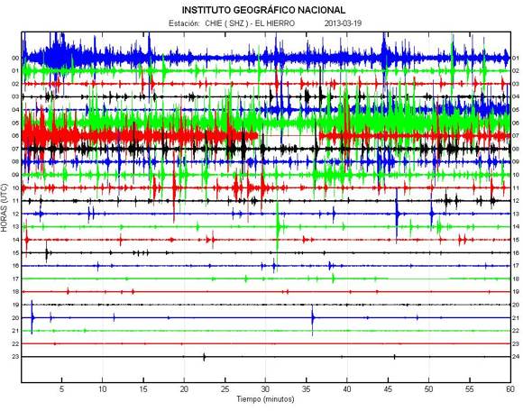
CHIE graph so far today - Image courtesy IGN
2013-03-19 17:24 UTC
A comment from Joke Volta, who has picked up her art work again, but wants to share a few words with our readers :
W will to wait a few more days to have a better view about the current intrusion. As it looks now, there is not enough “power” to end up in an eruption. But..well..this can change, just as the” sudden” appearance of this activity yesterday afternoon.
In the Golfo/Frontera-area people do feel the quakes. Down here in El Pinar, I do not notice movements…
It surely would not be safe to enter lava-tubes or discovering caves at this moment for the reason that there can be a gas-escape based on the current activity.
I hope that every visitor of the island will get information after or even before they arrive. Until now it is not dangerous, but I do recommend to get a steady information about the situation.Earthquake-report offers this 🙂 - regards to all of you, Joke
2013-03-19 16:25 UTC
- 94 earthquakes listed until 14:00 UTC
- The Salvamar Adhara has been cruising in the Las Calmas sea earlier today (based on data from Marinetraffic.com).
- The seismic activity has weakened considerably since 11 AM UTC. Strongest earthquake M2.6, depths unchanged.
2013-03-19 11:25 UTC
- NO real change at the moment. Same hypocenter depth. The AVCAN map below shows the epicenters of the last earthquakes (77 since midnight now). The quakes are gradually migrating to the unpopulated western part of the island, the greater area of the second last very intense seismic activity, only at that time most quakes were recorded at the deeper +20 km layer. In general, we do think that the present activity has chosen a new path, mainly in depth.
2013-03-19 08:07 UTC
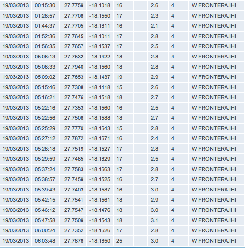
- 143 earthquakes yesterday alone !
- 24 earthquakes so far today (at least stronger ones as the number of volcanic earthquakes is much higher than this number). The strongest earthquake since midnight was a M3.1. The depth (or magma intrusion depth) is still located in between 16 and 18 km.
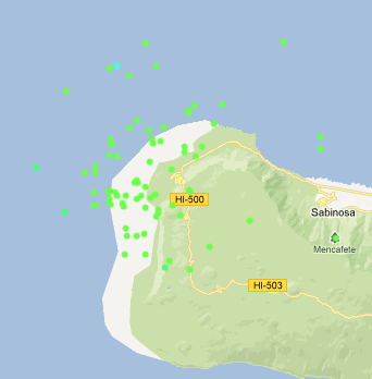
- The third map is the epicenter/hypocenter map. The red squares are showing the seismic activity of the last 12 hours. This activity is mainly located in the Sabinosa area (in the sea and below land).
- Important to look at for the following hours is an eventual migration of the epicenter and/or hypocenter location. Not a single event is important but the average of multiple events.
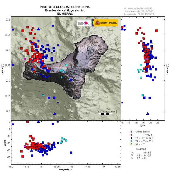
2013-03-18 18:36 UTC
- 54 earthquakes have been added to the list. This brings the total today to 121 listed earthquakes.
- Strongest earthquake since the last update M3.0
- The activity slows down considerably at the moment. This may lead to stronger earthquakes or to a further weakening of the magma pressure. The following 8 hours will give us a better overview of the strength of the current crisis.
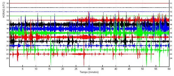
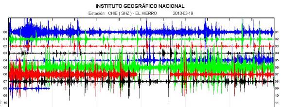
CHIE El Hierro graph, Image courtesy IGN Spain
2013-03-18 18:36 UTC
- 7 new earthquakes since the 17:39 UTC update
- The current tremor is showing new magma intrusion in the deeper layers 16 to 25 km in average.
- IGN has now refreshed their quake diagram (see below). Epicenters and hypocenters are easy to retrieve.

Image courtesy IGN, Spain
2013-03-18 18:10 UTC
- 7 new earthquakes since the 17:39 UTC update
- People following this report longer than today do know that IGN is only listing the stronger earthquakes during seismic crisis like today. In reality there are far more earthquakes than those listed by IGN.
- Activity is getting stronger again
2013-03-18 17:39 UTC
- 30 more earthquakes since our latest list update. Max. Magnitude 2.8. Tremor is gradually getting weaker again. The frequency of earthquakes is going down too. You can follow the seismic events here.

2013-03-18 15:58 UTC
- The epicenter location vs the depth gives a good indication of where the current activity is going on. Some examples (overview pictures from IGN and AVCAN are or not working or outdated)
- The images below are showing the the epicenters are not located in one specific area but merely in the road path of the first initial swarm.
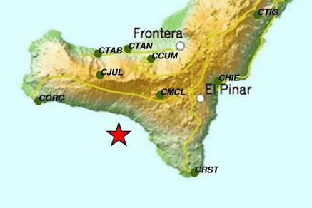
Epicenter for a recent M2.3 earthquake at 23 km depth (little to the north of the new crater)
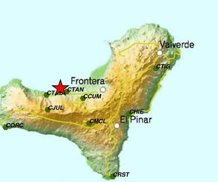
Epicenter of another M2.2 swarm earthquake at a depth of 22 km
2013-03-18 15:46 UTC
- A more impressive screenshot of the action on the hourly chart (the other one below is the same on the daily graph).
- We will probably be heading for a very long list of earthquakes. To avoid becoming boring, we will publish from now on the number of listed quakes and the strongest Magnitude.
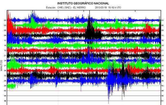
Image courtesy IGN, Spain
2013-03-18 15:27 UTC
- Thanks to ER readers Colin, Tommy, Chris and Vinch77 who have alerted us we can bring you this "breaking News".
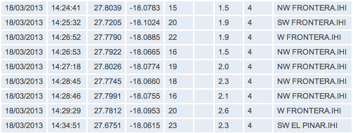
- A very strong seismic event has started at El Hierro. Check the HT graph and volcanic earthquakes list below (in a time-frame of only 10 minutes, 9 volcanic earthquakes have been listed by IGN + more to come).
- The hypocenter depth (location below the island where the action is), is however at 16 to 23 km, in other words too deep to become a direct danger for the islanders.

2013-03-18 11:36 UTC
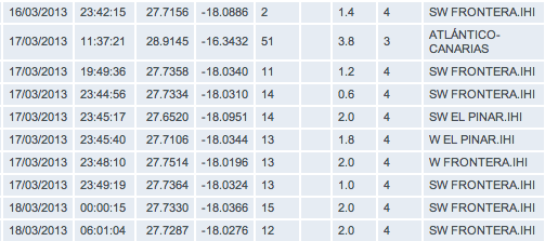
- The M3.8 earthquake which occurred yesterday to the North of Tenerife is a pure tectonic event as the hypocenter was reported at 51 km. There are more moderate tectonic earthquakes to the north of Tenerife.
- A small volcanic earthquake swarm occurred around midnight yesterday. Most of the epicenter below the central crater area of the island. No HT generated during that period. The strongest earthquakes are however visible on the CHIE graph

Links to earlier parts of this extensive El Hierro eruption report :
(28/7 – early 09) – (25/09 – 10/10) - (11/10 – 13/10)- (14/10 – 17-10) - (18/10 – 21/10) - (22/10 – 26/10 ) – (27/10 – 31/10 ) – (01/11 – 03/11 ) - (04/11 – 06/11 ) – (07/11 – 08/11) – (09/11- 11/11) – (12/11 – 15/11) – (16/11 – 19/11) – (20/11 – 23/11) – (24/11 – 27/11) – (28/11 – 02/12) -(03/12 – 07/12) – (08/12 – 11/12) – (12/12 – 15/12) – (16/12 – 18/12) – (19/12 – 25/12) – (26/12 – 31/12) – (01/01 – 03/01) – (04/01 – 07/01) – (08/01 – 13/01) – (14/01 – 19/01) - (20/01 – 25/01) - (26/01 – 30/01) – (31/01 – 04/02) – (05/02 – 10/02) – (11/02 – 16/02) – (17/02 – 23/02) – (24/02 –29/02) – (1/03 – 10/03) – (11/03 – 18/03) - (19/03 - 23/03) - (24/03 - 28/03) - (29/03 - 03/04) - (04/04 - 10/04) - (11/04 – 21/04) - (22/04 – 30/04) - (01/05 – 10/05) - Part 43 (11/05 – 31/05) - (01/06 – 14/06) - (15/06 – 24/06) - Part 46 (25/06 – 26/06) – Part 47 (27/06 – 28/06) – Part 48 (29/06 – 01/07) - Part 49 (02/07 – 06/07) – Part 50 (07/07 – 31/07) - Part 51 (01/08 – 31/08) - Part 52 (01/09 – 11/09) - Part 53 (12/09 – 30/09) - Part 54 (01/10 – 15/12) - Part 55 (16/12 – 16/03)
Part 56 (16/03 – 26/03) -
Read also : Scientific paper reveals massive historic Tenerife volcano flank collapse
Read also: Economic impact on El Hierro and the Canary Islands if an aerial eruption would occur
Volcano Discussion Panel : If you are a person who wants to discuss and read about all aspects of volcanoes, this discussion panel might be a very good place to hang around. Especially if we start speculating about what to happen next.


Speak Your Mind