Earthquake overview : An 8.6 magnitude earthquake occurred 500 km out of the coast of Sumatra. A second massive earthquake (aftershock) occurred a few hours later.
"I have Felt it" Reports --> see below + Let us know "how you have felt this earthquake"
To read the full story as it happened, we advise our readers to start at the lower part of the page (earthquake data).
This article has been written by James Daniell, Armand Vervaeck and Carlos Robles
Keep this page open or return regularly as we will be back with more details when they become available
-
- Update 23/04 - 08:19 UTC
Indonesian authorities have reported that finally 10 Indonesians died, all of them indirect (heart attacks, jumping in panic out of a tree, etc)
- Update 12/04 - 15:45 UTC
* 50 inmates from the Sigli state prison have not returned after the gates have been opened by the prison management. On the outside cries that the water was rising, state prison director decided to open the gate. It must have been done in chaos as only 13 of the 63 inmates have returned to the prison. The other 50 are on the run with the police coming after them.
- Update 12/04 - 09:56 UTC
* The Minister of Communications and Information Technology, Tifatul Sembiring, has obtained from telecommunication operators that disturbed communications on Sumatra will all be operational again in approx. 3 days
* Schools are not yet recovered of all the havoc and not yet fully operational today
* Minister of Communications and Information Technology, Tifatul Sembiring, reads our pages regularly we think, because he also said today that too many "speaking on the phone" are creating saturation of telecommunications traffic. Click here to read our in-depth reporting of this subject.
- Update 12/04 - 08:44 UTC
* Indonesian authorities have reported that 5 people have been killed by the earthquake on the island of Sumatra. 7 people have been reported injured (1 child is critically injured when she jumped in panic out of a tree). 3 people died of a heart attack. Massive earthquakes have a very emotional impact on Indonesians since in 2004 so many people were killed by a tsunami in the same area as yesterday's earthquakes. The killed and injured reported so far are indirect fatalities which are related to the earthquake.
* The main airport of Simeulue island (island closest to the epicenter) was closed. Simeulue had no power and communications were disturbed (unbelievable in earthquake-report.com terms ! - One should think that after the 2004 tsunami and devastating earthquake, authorities should have a viable system in place to at least reach strategic locations like the main Simeulue airport).
- Based on the injured and killed Sumatrans, this earthquake will be labeled CATDAT ORANGE
- On our Major daily earthquakes list from April 11, you can see an impressive list of aftershocks. The list is especially long because we are publishing the data of EMSC, GFZ and USGS.
Update 21:55 UTC
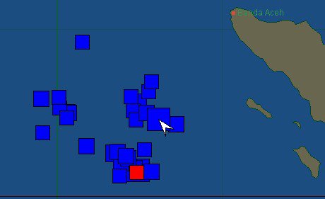
The aftershocks are continuously hitting th sea floor. The image below shows the epicenters of the many aftershocks. The red square is the latest one and the square with a white arrow is the mainshock of 8.6. The area where the aftershocks have occurred is approx. 1000 square kilometer? Since the mainshock we have counted 31 M+5 aftershocks. We expect the aftershocks to gradually decrease in strength but at the same time we also expect some very strong ones to happen now and then. Let's hope that the whole area (especially the Burma Plate and the Sumatra fault) will remain calm.
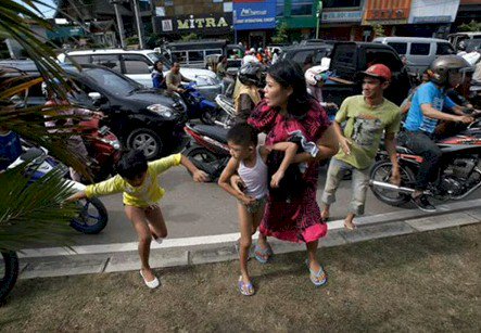
People in Banda Aceh running away from their location to higher grounds
Update 20:37
Indonesia is checking for damage and casualties but remarkably, no such reports had been received for several hours after the quakes, including in Aceh province, the closest province and the area decimated by the disaster eight years ago. Many people are frightened for further tremors. People want to stay alert because of the fear that more quakes are coming.
Update 18:51 UTC
The small wave caused $220,000 (2 billion rupiah) damage (estimated) to a bridge and a house. Damage to the bridge was in Bubon Arongan
Update 16:23 UTC
Also Indonesia has now lifted the tsunami alert. We had to wait several minutes to reach the BMKG website, as we were ourselves victims of saturated servers, we feel pity with the Indonesian seismologists.
Billions of dollars are paid to cover earthquake and tsunami insurances but some seed money to strengthen specialist sites like the seismological agencies and our site are seemingly too much for the insurance companies. Saturated servers are a common problem for event driven websites like earthquake-report.com
Update 15:46 UTC
So why was this earthquake the largest non-damaging earthquake ever measured?
a) It occurred 400km+ offshore, thus the earthquake shaking only achieved a maximum intensity of around 5.5-6 in the closest points to land, causing no discernable damage.
b) the earthquake, unlike other major M8+ earthquakes, was a strike-slip earthquake, where plates slide past one another, and not upwards or downwards. Therefore, there was not much offset on either side of the fault and thus the water volume was not significantly displaced and therefore caused NO MAJOR TSUNAMI (highest was at Meulaboh with 1.05m)
c)13 other earthquakes over Mw8 since 1900 have caused no damage, however, the Mw8.6 was the highest by Mw0.4 (around 3 times the ground motion and 7 times more energy than ever before to cause no damage!!!!)
The Mw8.2 earthquake which occurred a couple of hours later was the 3rd largest earthquake recorded to cause no damage.
In one of the many experience reports, a person from Banda Aceh wrote earthquake-report.com : hard too remain standing, iMac in the office hopping madly all over the desk, people panicking and leaving the city because of tsunami warnings
- So far we there were 23 M5+ aftershocks after the mainshock. 2 of the aftershocks were even bigger than M6
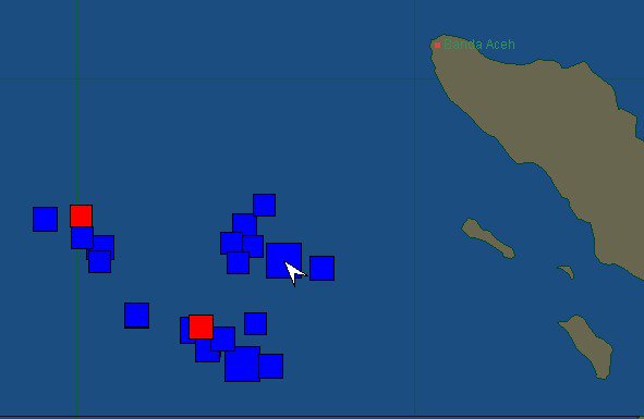
Location of the aftershocks until 15:41 UTC - red blocks are the lastest ones, block with the white arrow in it is the location of the epicenter's mainshock
Update 15:20 UTC
We got a message on our computer for Maldives touroperator IMPEX Holydays. The touroperator is telling his client travel agencies soon after the earthquake what the situation was at the Maldives. This is truly an 'example of how today's communication has to work. Congratulations to Impex Holidays.
"Dear All Partners,
Greetings from Maldives.
We wish to inform all our partners the situation in Maldives is calm although we slightly felt the 8.6 magnitude earth quake which hit Aceh, Indonesia this afternoon.
As of now, 1725 hrs local Maldives time the authorities have extended the tsunami alert time till 1930 hrs due to the second after shock quake.
All inhabited islands as well as the resort islands are on full alert, although sources have informed that the chances of a tsunami is unlikely.
e wish all tourists in Maldives well and pray that we will be safe."
Update 13:57 UTC
- A tsunami watch has been cancelled now for the entire Indian Ocean area
Earthquakes since 1900 over M8 that were non-damaging
Today's 2 earthquakes of Mw8.6 and Mw8.2 are among the Top 13 strongest magnitude non-major damaging event earthquakes of the last 113 years in CATDAT
Mw8.1 - January 13, 2007 - Kuril Islands
Mw8.1 - December 23, 2004 - North of Macquarie Island
Mw8.1 - March 25, 1998 - Balleny Islands Region
Mw8.1 - May 23, 1989 - North of Macquarie Island
(Mw8.1 - January 10, 1971 - Very Minor damage to a church etc. - Papua, Indonesia)
Mw8.5 - October 13, 1963 - Kuril Islands (v. minor damage)
Mw8.2 - November 10, 1938 - Alaska
Mw8.0 - September 20, 1920 - Loyalty Islands Region
Mw8.0 - May 1, 1917 - Kermadec Islands, NZ
Mw8.0 - May 1, 1915 - Kuril Islands
Mw8.0 - January 4, 1903 - Tonga
Mw8.0 - 1902 - Sea of Okhotsk
- Meulaboh (Northern Sumatra) has recorded waves up to 1.06m
- The second fault solution has been confirmed as a strike-slip - meaning little chance of tsunami. Probably only minor given the slight dip.
This is the largest non-damaging earthquake for a long time of this magnitude.
- Below this page you will find a very big number of earthquake experience reports from our readers. We thank them all to share their experience with earthquake-report.com
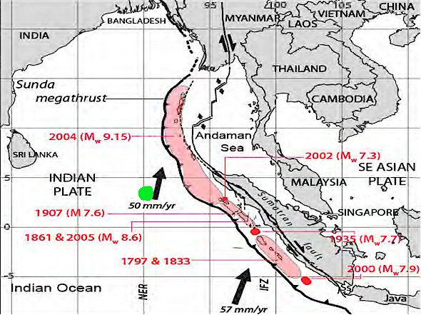
- The epicenter of the earthquake is located about 100 km to the west of the subduction fault line in the Oceanic part of the Indian plate and not in the direct subduction zone of the plates. The subduction zone is far more dangerous than stress in the oceanic plate itself. The actual greater area is the intersection in between the Indian Plate, the Australian plate and the Burma plate.
- A NOAA employee just told CNN that the max. water level change which has been measured so far was 1 meter, which confirms our earlier expectation that due to the type of the 1th earthquake (strike/slip) the impact would be limited.
- We will still have to wait for the earthquake data of the second massive earthquake. The mechanism (type of earthquake) is not necessarily the same for both earthquakes
- This link gives you an idea of the impact of the earthquake on a deep ocean buoy out of the Phuket coast Thailand). The differences in level is limited. Click here for the graph and the detailed page
- Aftershocks are continuing to hit the epicentral area
- It is really VERY GOOD news that the coast in Northern Sumatra has not reported any serious damage or injuries. This coast is the nearest to the epicenter.
Update 11:42 UTC
- Power if off at Banda Aceh
- Why is it far too early to give the final "safe" message ? Because Indonesia and also locations like the Andaman Islands have a lot of smaller islands and every coastal area can react differently to incoming waves.
- The first 8.6-magnitude quake off Aceh province, hours earlier, spawned a wave around 80cm high but caused no serious damage. We will have to wait anxiously whether the second earthquake hasn't generated higher destructive ways, probably not but far too early to say so.
- Another area which was also very hard hit in 2004 is India's Andaman Islands. No news so far from that area of the world, but we will follow news from the Andaman Islands too
A very good "early" video report from ABC news Australia
- As said before the current earthquakes have only limited similarities with the destructive 2004 earthquake and tsunami. The main movement, as presently known, was lateral versus up and down during the 2004 earthquake. That earthquake was also more powerful.
- This is the latest NOAA bulletin on the basis of the last massive aftershock :
THIS BULLETIN IS FOR ALL AREAS OF THE INDIAN OCEAN. ... AN INDIAN-OCEAN-WIDE TSUNAMI WATCH IS IN EFFECT ... ... A MAJOR AFTERSHOCK OCCURRED AT 11:43Z WITH MAGNITUDE 8.3 ... A TSUNAMI WATCH IS STILL IN EFFECT FOR INDONESIA / INDIA / AUSTRALIA / SRI LANKA / MYANMAR / THAILAND / MALDIVES / UNITED KINGDOM / MALAYSIA / MAURITIUS / REUNION / SEYCHELLES / OMAN / PAKISTAN / SOMALIA / MADAGASCAR / IRAN / UAE / YEMEN / COMORES / MOZAMBIQUE / KENYA / TANZANIA / CROZET ISLANDS / BANGLADESH / KERGUELEN ISLANDS / SOUTH AFRICA / SINGAPORE
THIS BULLETIN IS ISSUED AS ADVICE TO GOVERNMENT AGENCIES. ONLY NATIONAL AND LOCAL GOVERNMENT AGENCIES HAVE THE AUTHORITY TO MAKE
DECISIONS REGARDING THE OFFICIAL STATE OF ALERT IN THEIR AREA AND ANY ACTIONS TO BE TAKEN IN RESPONSE.
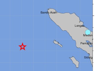
- People is Simeulue Island (closest to the epicenter) have now been reporting that the water on the beaches was treating about 10 meters (must have been generated by the second quake). A receding ocean can be the sign of an upcoming tsunami but often the receding is everything what happens too. So, we will have to wait for more news. This may have been caused by another earthquake wave propagation after the second earthquake
- Due to the many sometimes violent aftershocks, the tsunami watches will bot be lifted and people have to stay on higher ground
- The second massive quake has been decreased to 8.2 by USGS, it has to be seen as a massive aftershock
- A NEW POWERFUL M 8.6 earthquake occurred at this time in the almost same epicenter area!
- It is still too early to tell whether there was no tsunami at all as reports are mixed. Depending on the propagation of the wave and the coastal relief, places where a tsunami occurs are not necessarily the same.
Update 10:42 UTC
- Most aftershocks have an epicenter on a safe distance out of the Sumatra coast
- At this moment we can only tell that a real destructive tsunami has not yet occurred as far as we know. Additionally the epicenter is too far out of the coast to be shaking damaging. Light damage is still possible of course as the highest expected shaking is still a strong MMI VI shaking.
- People in the most dangerous area are well prepared these days and were also immediately alarmed to seek higher ground
- a number of hospitals in Banda Aceh have been evacuated. Patients have been brought to higher grounds
- Many (powerful) aftershocks have occurred since the mainshock
- India's tsunami warning center said waves measuring up to 6 meters were expected along parts of its eastern coast
- Very good news comes from Indonesia : Indonesia's disaster mitigation agency says no detection of low tide that would indicate tsunami in Aceh (Reuters twitter)
- seismologists are reporting the the earthquake was from another type than the 2004 one. The thrust force was far less this time than in 2004. Thrust force is mainly generating tsunamis like what was the case in Japan
- As far as we know now - the closest shores (Northern Sumatra) has not yet experienced any important level change
- British Prime Minister Mr Cameron is visiting the country’s capital, Jakarta, which is 1,600 miles south-east of the province and on a different island, Java. He said he was 'hugely concerned and ready to help'. There were reports of the water level dropping in the Thai resort of Phuket - a sign that the sea is drawing back in preparation to launch an enormous wave.
- To follow the Tsunami Bouy disturbances LIVE please follow this link ; http://www.ndbc.noaa.gov/
- NOAA PACIFIC latest bulletin :
A TSUNAMI WATCH IS IN EFFECT FOR INDONESIA / INDIA / AUSTRALIA / SRI LANKA / MYANMAR / THAILAND / MALDIVES / UNITED KINGDOM / MALAYSIA / MAURITIUS / REUNION / SEYCHELLES / OMAN / PAKISTAN / SOMALIA / MADAGASCAR / IRAN / UAE / YEMEN / COMORES / MOZAMBIQUE / KENYA / TANZANIA / CROZET ISLANDS / BANGLADESH / KERGUELEN ISLANDS / SOUTH AFRICA / SINGAPORE
THIS BULLETIN IS ISSUED AS ADVICE TO GOVERNMENT AGENCIES. ONLY NATIONAL AND LOCAL GOVERNMENT AGENCIES HAVE THE AUTHORITY TO MAKE
DECISIONS REGARDING THE OFFICIAL STATE OF ALERT IN THEIR AREA AND ANY ACTIONS TO BE TAKEN IN RESPONSE.
- We reiterate that BOTH Northern Sumatra and the Indonesian island of Simeulue are at the highest tsunami risk
The surrounding countries like India, Thailand, Malaysia and SRI LANKA are at high risk too
- Sri Lanka and India issued tsunami warnings while Thailand urged people on the Andaman coast, a popular tourist destination, to move to safety.
- A Sri Lanka government statement said waves could hit the island's eastern coast by about 1040GMT and urged an orderly evacuation of the coastal strip.
- Update 10:16 UTC
- Indonesia's disaster mitigation agency is sending a rescue team to Aceh, after a massive 8.7 magnitude quake on Wednesday and tsunami warning knocked out the province's electricity and send locals scrambling for higher ground.
- "The quake was felt very strongly. Electricity is down, there's traffic jams to access higher ground. Sirens and Koran recitals from mosques are everywhere," said Sutopo, spokesman for Indonesia's disaster mitigation agency.
- USGS has decreased the magnitude to 8.6 and 22.9km depth
- Residents in Banda Aceh reported the ground shaking violently.
- "People are in a panic, and there are traffic jams everywhere in Banda Aceh," local Metro TV reported.
- "There is potential for a tsunami to hit five provinces in the region -- Aceh, North Sumatra, West Sumatra, Bengkulu and Lampung," said Marzuki, an analyst at Indonesia's Geophysics and Meteorology agency.
- "Earthquakes of this size have the potential to generate a widespread destructive tsunami that can affect coastlines across the entire Indian Ocean basin," the US Pacific Tsunami Warning Center said.
- In India, the authorities issued a tsunami warning for the Andaman and Nicobar Islands, located in the Indian Ocean.
- The Indian National Centre for Ocean Information Services issued a red high-level warning for the islands, and also put out lower alerts for the coasts of Andhra Pradesh and Tamil Nadu states in the southeast of the country.
- There was chaos in the streets, with fierce shaking continuing for nearly four minutes.
"I was in the shower on the fifth floor of my hotel," Timbang Pangaribuan told El Shinta radio from the city of Medan. "We all ran out. ... We're all standing outside now."
He said one guest was injured when he jumped from the window of his room.
- The tremor was felt in Singapore, Thailand, Bangladesh, Malaysia and India. High-rise apartments and offices on Malaysia's west coast shook for at least a minute.
- Thailand's National Disaster Warning Center issued an evacuation order to residents in six provinces along the country's west coast, including the popular tourist destinations of Phuket, Krabi and Phang-Nga.
- A tsunami watch was issued for countries across the Indian Ocean after a large earthquake hit waters off Indonesia on Wednesday, triggering widespread panic as residents along coastlines fled to high ground in cars and on the backs of motorcycles.
Some were crying. Others screamed "God as great" as they poured from their homes.
- we have terrible problems in being able to stay online as the server crashes regularly. Lack of finance for better solutions is witholding us from being more performant.
- People on Twitter said tremors were felt in Singapore, Thailand, Malaysia and India. High-rise apartments and offices on Malaysia's west coast shook for at least a minute
The power has gone out in Banda Aceh and residents are moving to higher ground, said Sutopo Purwo Nugroho, a spokesman for the Indonesian National Disaster Management Agency.
The extent of the damage is still being assessed.
The quake was felt as far away as Bangkok and in southern India, residents said. Hundreds of office workers in Bangalore left their buildings, workers there said.
The quake was in roughly in the same area as a December 26, 2004, quake of 9.1 magnitude, which sent huge tsunami waves crashing into Sumatra
- A tsunami warning has been issued as Indonesia’s geophysical agency has registered an 8.9 magnitude earthquake in the Aceh region, off the western coast of northern Sumatra.
- USGS has calculated that 547,000 people will have experienced a MMI VII Very strong shaking. Earthquake-Report.com does NOT expect shaking victims BUT we expect serious danger for the Northern Sumatra coast (Banda Aceh area) and Simeulue island, both areas who were hardest hit in the earlier tsunamis
- USGS has decreased his initial magnitude from 8.9 to 8.7. Other agencies are reporting lower values (a big difference)
- NOAA is publishing good news for the USA west coast : ...A STRONG EARTHQUAKE HAS OCCURRED BUT A TSUNAMI IS NOT EXPECTED ALONG THE CALIFORNIA/ OREGON/ WASHINGTON/BRITISH COLUMBIA OR ALASKA COASTS... NO WARNING... NO WATCH AND NO ADVISORY IS IN EFFECT FOR THESE AREAS.
BASED ON LOCATION OF THE EVENT BEING OUTSIDE THE PACIFIC BASIN THE EARTHQUAKE WAS NOT SUFFICIENT TO GENERATE A TSUNAMI DAMAGING
TO CALIFORNIA/ OREGON/ WASHINGTON/ BRITISH COLUMBIA OR ALASKA. RESIDENTS IN THE INDIAN OCEAN REGION SHOULD REFER TO THE PACIFIC
TSUNAMI WARNING CENTER MESSAGE.
- GDACS has issued a green earthquake report, but we predict that it will change soon into a RED tsunami report. Nor GDACS, not NOAA have issued tsunami notes yet, but we expect them to arrive soon.
- due to the huge number of people coming to read our report, the server hangs regularly even for us writing in it
- This earthquake has a lot of similar data as the giant destructive earthquake and tsunami from many years ago, killing thousands of people. A general tsunami alarm looks imminent for the entire area
- Extremely dangerous earthquake
Preliminary data are saying a +8 magnitude
The earthquake has been felt in Thailand and in Malaysia
A tsunami alarm will certainly in place in large parts of the area
Earthquake-Report.com GOOGLE+ / Earthquake-Report.com FACEBOOK
"I Have Felt It" reports as received by Earthquake-Report.com
See below for all the received Earthquake Experience reports as received by earthquake-report.com
Most important Earthquake Data:
Magnitude : 8.6 (USGS)
UTC Time : Wednesday, April 11, 2012 at 08:38:30 UTC
Local time at epicenter : Wednesday, April 11, 2012 at 02:38:30 PM at epicenter
Depth (Hypocenter) : 22.9 km
Geo-location(s) :
495 km (308 miles) SW (219°) from Banda Aceh, Sumatra, Indonesia
Links to important maps
USGS Did You Feel It Map
Google satellite map showing the epicenter and the surrounding area
Historic earthquakes map
Seismic hazard map
Shaking map
Focal mechanism report
Human impact map
GDACS earthquake report
NOAA tsunami report
I Have Felt this earthquake
Refresh this list
SRC
Location
UTC Date/time
M
D
INFO
USGS
Off The West Coast Of Northern Sumatra
Apr 11 10:43
8.2
16
MAP
USGS
Off The West Coast Of Northern Sumatra
Apr 11 08:38
8.6
22
MAP
GEOFON
Off West Coast Of Northern Sumatra
Apr 11 08:38
8.6
10
MAP
USGS
Off The West Coast Of Northern Sumatra
Apr 11 08:38
8.9
33
MAP
a

QuakeSOS+ and QuakeSOS free are iPhone applications developed by Armand Vervaeck, the founder of Earthquake Report. The Application simplifies immediate group communication to friends and family members (with your exact GPS location) and is feeding the users with Earthquake Report news. The 0.99 US$ QuakeSOS+ version will support the activities of SOS Earthquakes.
a
Earthquake-Report.com headlines on twitter
@OnlyQuakeNews : Get all the headlines of our earthquake-report.com articles + regular updates on ongoing events
@QuakeSOS : earthquake-report.com news + automatic earthquake notifications of USGS earthquakes of M 4.0 or higher with emphasis to earthquakes in the America's and the Pacific Ocean sphere (4 and up) and a lot of the rest of the world (5 and up). This account was created for our QuakeSOS and QuakeSOS+ iPhone applications
@ShakingEarth : earthquake-report.com news + automatic earthquake notifications of EMSC earthquakes of M 4.0 or higher with emphasis to earthquakes in European and Asian / Middle East sphere (4 and up) and a lot of the rest of the world (5 and up). This account was originally created to stimulate our Facebook account
@QuakeMaps : earthquake-report.com news with mapping notifications of ALL earthquakes M 3.0 and higher from all over the world via EMSC and USGS. This account was created for our http://www.quake-maps.com website



don't be relaxed, stay alerted and warned, the release of huge quake energy may
be likely on its destructive way
semoga Ketuhanan bantumu!
What school do you go to, Alex