With special thanks to Dr. Carracedo (Geovol) allowing us to publish his report and Joke Volta for facilitating.
Dr. Juan Carlos Carracedo Gómez - ULPGC
Forty years after the Teneguía Volcano (La Palma, 1971), a submarine eruption took place off the town of La Restinga, south of El Hierro, the smallest and youngest island of the Canarian Archipelago. Precursors allowed an early detection of the event and its approximate location, suggesting it was submarine. Uncertainties derived from insufficient scientific information available to the authorities during the eruption, leading to disproportionate civil protection measures, which had an impact on the island’s economy based primarily on tourism, while residents experienced extra fear and distress.
El Hierro, 1.12 million years old, is the youngest of the Canary Islands. Located at the western end of the archipelago together with the neighboring island of La Palma, El Hierro rests on a ca. 3500 m-deep ocean bed.
The principal configuration of El Hierro is controlled by a three-armed rift zone system that gives rise to three ridges that extend from the center of the island in a characteristic ‘Mercedes star’ geometry (Carracedo, 1994), and host the larger part of El Hierro’s subaerial eruptions (Fig. 1A).
This triple-armed shape of El Hierro is further enhanced by the scars of several massive gravitational landslides that truncate all three flanks. The collapse of the north flank, that formed the spectacular El Golfo bay with an almost vertical 1400 m-high escarpment, is the youngest landslide of the entire Canary Archipelago with an age of less than 100 ka. Rift zones, however, also continue underneath the sea surface. The south rift stretches as a submarine ridge for more than 40 km (Fig. 1B), indicating that recent submarine eruptions have occurred there as well.
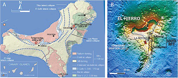
Fig. 1. A. Geological map of El Hierro (from Carracedo et al., 2001). B. colour shaded relief image of El Hierro viewed from above (from Masson et al., 2002). The subaerial and submarine parts of the South rift are indicated.
During the German research cruise Meteor 43/1 in 1998, lava samples were dredged from the submarine prolongations of the southern rift zones of La Palma and El Hierro. El Hierro samples taken close to the present eruptive site (<3 km distant) included fresh picrites and alkali-basalts and variably altered lapillistones and hyaloclastites. Further dredging along the submarine north-west and north-east rift zones during the Poseidon 270 cruise in 2001 recovered fresh alkali basalts from 21 young volcanic cones at depths of 800 to 2300 m together with ocean bottom sediments having a strong volcaniclastic component.
It appears overall that the density of seemingly young volcanoes on El Hierro’s submarine rifts is comparable to that on land, emphasizing the relevance of submarine eruptions during the growth of oceanic islands.
Precursors to the 2011 eruption
Numerous earthquakes were recorded by the Spanish Instituto Geográfico Nacional (IGN) from July 2011 onwards, the greater part of them insignificant from a hazard point of view, but were clearly precursors of a volcanic eruption. In particular, seismicity, initially of low magnitude (M < 3.0) and focused north of the island, increased while migrating southward. The greater part of the hypocentres were initially concentrated within the lower oceanic crust (Fig. 2), at depths of 8–14 km (ca. 200–400 MPa pressure), which is in agreement with pressure estimates from microscopic fluid inclusions in xenoliths from north-western El Hierro and phenocrysts from a recent eruption. The seismic and petrological data are thus in-line with a scenario of a magma batch becoming trapped as an intrusion horizon, near the base or within the subisland oceanic crust. Shifting seismic foci suggest that magma progressively accumulated and expanded laterally in a southward direction, causing a vertical surface deformation of about 40 mm at that time.
During this initial phase, the system remained active but showed no sign of having overcome the resistance of the oceanic crust. Hypocenters thereafter migrated south-east, approaching the submarine prolongation of the active South rift zone. From there, the magma progressed rapidly towards the surface, as indicated by the first time occurrence of shallow (< 3 km) earthquakes on 9 October 2011.
The scenario changed dramatically at about 4 am on 10 October, when the now frequent and strong seismicity (up to M 4.4) ceased and was rather abruptly replaced by a continuous harmonic tremor, indicating the opening of a vent and thus the onset of a submarine eruption.

Fig. 2. Seismic hypocentres beneath El Hierro between 19 July and 10 October 2011. Hypocentres migrated from North towards the South rift zone of the island, where they became shallower (< 3 km). The eruption commenced on 10 October. Most of the time, seismicity remained stable at the base of the oceanic crust (data from IGN, http://www.ign.es/ign/resources/ volcanologia/ html/eventosHierro. html)
The submarine eruption
On October 10, patches of pale-colored water that smelled of sulfur and were associated with dead fish, were found floating one mile south of the coast confirming the opening of a vent on the flank of the submarine part of the South rift zone. The surface expression of this eruption, including green and bright discoloration of seawater, was clearly observed in high-resolution satellite images featuring a large stain (locally known as ‘la mancha’) visible on the surface of the Las Calmas Sea (Fig. 3A). The eruption formed a NE–SW trending fissure outlined by strong bubbling and degassing (Fig. 3B), occasionally 10–15 m high, loaded with juvenile volcanic ash and pyroclasts (Fig. 3C).
However, information on the depth and precise location of the submarine vent was lacking in the first two weeks of the eruption because of the unavailability of adequate means for submarine surveying.
On October 24, the RV Ramón Margalef of the Instituto Español de Oceanografía (IEO) carried out the first survey of the area, previously mapped in 1998 by the Spanish RV Hespérides (Fig. 4A). Comparison of present and 1998 bathymetry outlined a 700 m-wide, 100 m-high new volcanic cone resting at about 350 m depth in a canyon on the flank of the South Rift submarine extension (Fig. 4B). On 4 December 2011, the eruption apparently waning, the RV Ramón Margalef carried out another campaign, detecting significant growth of the volcanic edifice. The initial single eruptive center (Fig. 4A,B) had now evolved to three cones of similar height, with their summit 180–160 m below the sea surface (Fig. 4D), still below the critical value to generate significant surtseyan explosions (about 100 m below sea level).
Lava flows and pyroclasts, confined by the canyon walls, caused the greater part of the erupted volume to flow downslope towards deeper parts of the ocean floor.
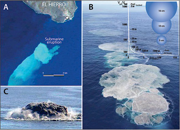
Fig. 3. A. Plume of dissolved magmatic gases and suspended matter producing green and bright discolouration of seawater (locally known as ‘la mancha’) commencing on 10 October 2011 and continuing for several kilometres to the south-west before drifting off into the Atlantic (Satellite image by RapidEye). Fig. 3. B. Plumes of gas on ocean surface showing a N–S trend, indicating a submarine eruptive fissure. Inset: Expansion of steam with decreasing water depth (modified from Schmincke, 2004). C, strong degassing with abundant rock fragments generated large ‘bubbles’, some of them 10–15 m-high, bursting to the surface off the nearby village of La Restinga (8 November 2011).
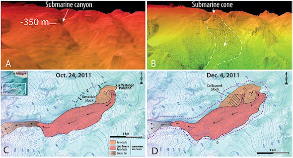
Fig. 4. A. DEM showing the pre-eruptive submarine canyon where the 2011 eruption nested (image taken from the RV Hespérides, 1998). B. DEM of the same area taken on 24 October by the RV Ramon Margalef after the onset of underwater activity. C. Geological map of the submarine eruption from the first DEM obtained on 24 October 2011 by the RV Ramon Margalef. D. Geological map of the same area on 4 December 2011.
Floating stones off El Hierro
Abundant rock fragments resembling lava bombs on a decimeter scale (Fig. 5) and characterized by glassy basaltic crusts and white to cream-colored interiors, were found floating on the ocean surface during the first days of the eruption. The interiors of these floating rocks are glassy and vesicular (similar to pumice), with frequent mingling between the pumicelike interior and the enveloping basaltic magma (Fig. 5B). These floating rocks have become known locally as ‘restingolites’ after the nearby village of La Restinga. Their nature and origin remained elusive at first, with suggestions from the scientific community including: (1) the floating bombs are juvenile and potentially explosive high-silica magma; (2) they are fragments of marine sediment from the submarine flank of El Hierro; and (3) that they are relatively old, hydrated volcanic material. However, none of these interpretations provides a satisfying fit to the available observation since for instance, high-silica volcanism is uncommon on El Hierro, and magmatic minerals (either grown in magma or as detritus from erosion) are entirely absent in the ‘restingolites’. Given that the involvement of highly evolved, high-silica magmatism would have implications for the explosive potential of the eruption, it was important to clarify the nature of the ‘restingolites’ swiftly in order to fully assess the hazards associated with the ongoing El Hierro eruption. Furthermore, should the ‘restingolites’ be shown not to originate from high-silica magma, then unraveling their genesis will most likely provide unique insights into the volcano–magma system beneath El Hierro.
All ‘restingolite’ samples are glassy and light in color and most are macroscopically crystal-free. However, occasional quartz crystals, jasper fragments, gypsum aggregates and carbonate relicts have been identified in hand specimens. X-Ray diffractograms mainly indicate the presence of quartz, mica and/or illite, and glass. There is a notable absence of primary igneous minerals from the XRD data. Microscopic quartz crystals have also been identified and analysed using a field emission electron probe micro-analyser (FE-EPMA), as well as the composition of the glass matrix, which ranges between ~65 and 90 per cent SiO2.
The high silica content coupled with overall low incompatible trace element concentrations, the occurrence of mm-sized relict quartz crystals and the lack of igneous minerals, plus the occurrence of carbonate, clay, jasper and gypsum relicts are all ncompatible with a purely igneous origin for the cores of the floating stones. Igneous rocks on El Hierro do not contain any free (primary) quartz crystals (nor do igneous rocks on any of the other Canary Islands).
A potential source of the quartz crystals found in the floating rocks from El Hierro is likely to be the sediments of layer 1 of the pre-island ocean crust. These contain quartz crystals transported from Africa by both wind and turbidity currents and are characterized by a lack of igneous minerals due to their pre-island age.
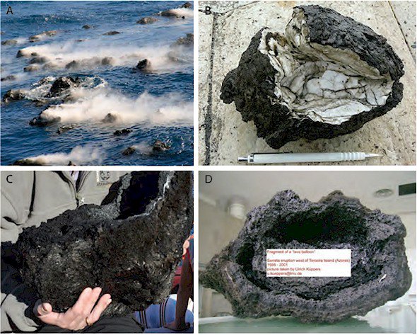
Fig. 5. A. ‘floating rocks’ observed in October 2011 off El Hierro. B. ‘restingolite’ sample displaying typical features, such as a crust of basalt, primary sedimentary bedding, folding, high vesicularity, and mingling structures. C. hollow basaltic bomb of the late stages of the eruption. D. similar bomb from the Serreta Oceanic Volcano, Terceira, Azores (photograph by Ulrich Küppers).
The floating rocks found at El Hierro are thus most probably the products of magma–sediment interaction beneath the volcano (Fig. 6). Ascending magma mixes with the pre-volcanic sediments and the ‘restingolites’ were carried to the ocean floor during eruption while being melted and vesiculated during transport in magma. Once erupted onto the ocean floor, some of them were able to separate from the erupting lava and floated to the sea surface due to their low density (Fig. 6).
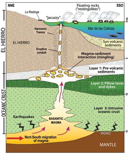
Fig. 6. Sketch showing the structure of El Hierro Island and the 2011 events. Ascending magma that, according to the distribution of seismic events prior to eruption, moved sub-horizontally from north to south in the oceanic crust, is interacting with the pre-volcanic sedimentary rocks. The floating rocks found at El Hierro during the early days of the eruption are the products of magma– sediment interaction beneath the volcano. These ‘restingolites’ were carried to the ocean floor during eruption and melted and vesiculated while immersed in magma. Once erupted onto the ocean floor, they separated from the erupting lava and floated on the sea surface due to their high vesicularity and low density (from Troll et al., 2011).
Management of the eruption
A dramatic account entitled ‘How not to handle a volcanic eruption’, was published on 31 October 2011, in one of the most influential newspapers in Spain, El Pais. The article discussed the response to the eruption: ‘Since July 19, residents of the Canary island of El Hierro have been preparing for a possible eruption of a volcano a few kilometres out at sea. Scientists headed to the area, the regional government of the Canary Islands put in place preparations for a possible sea and air evacuation, and the Spanish military moved in. Measures taken to protect El Hierro’s population (11 000), however, have been criticized by the residents as more disruptive than the volcano itself. Many residents are now wondering whether the authorities had any real idea of what was going on with the volcano, and whether there was any real danger to human life’ (http://www.elpais.com/ rticulo/english/How/not/to/handle/volcanic/eruption/elpepueng/20111031elpeng_4/Ten).
Management and civil protection decisions before and during the eruption were the responsibility of the Directorate of the Civil Protection Special Planning and Emergency Response Organisation to Volcanic Risk in the Canary Islands (PEVOLCA). The handling of the eruption by this committee, set up by the Canarian Government only a year before, suggests a lack of experience on PEVOLCA’s part and hence a considerable degree of improvisation. Repeated evacuations of La Restinga (600 residents), seemingly random closure and reopening of a section of the island’s main road as it passes through a tunnel (earthquake risk), and the two-week delay in sending a survey vessel are, among others, the main causes of frustration felt by the local population (see Fig. 7). Due to these uncertainties the island’s economy, based primarily on tourism, collapsed temporarily and residents experienced extra fear and distress.
The overall relatively low magnitude seismicity (the greater part of magnitudes < M 3.0), and the comparatively small and deep (> 150 m) basaltic submarine eruption seems thus to have caused surprisingly greater distress and economic loss than a similar magnitude eruption on land in 1971 (Teneguía Volcano, La Palma). This eruption was managed 40 years ago without disturbing the population to the same extent or causing economic hardship.
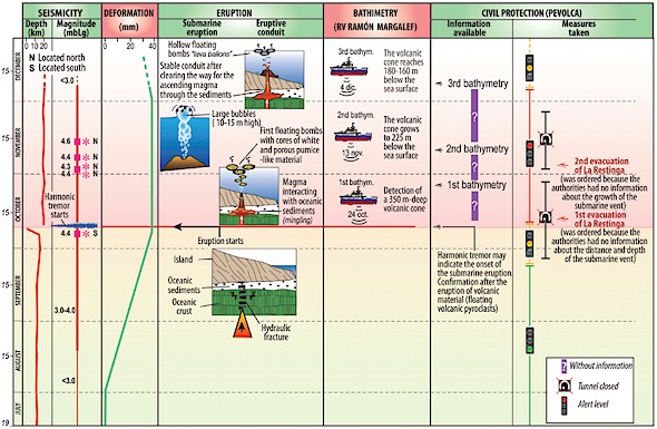
Fig. 7. Scientific information available during the 2011 submarine eruption in El Hierro and civil protection measures taken.
One explanation is that, in contrast to the 1971 Teneguía eruption, during the 2011 eruption accurate scientific information was not available at decisive points to dispel uncertainties and provide appropriate criteria to manage the situation (Fig. 7). The plan for volcanic emergencies by PEVOLCA tasks the National Geographic Institute (IGN) with managing the scientific aspects. IGN geophysicists analyzed and interpreted correctly the seismic precursors, allowing early detection of the time and approximate location of the eruption, and predicting it to be submarine. However, at the onset of the eruption a small group of scientists took charge to the exclusion of others, ignoring independent observations and data. Thus, objective scientific advice to enable the authorities to make the correct decisions at crucial points in time was not forthcoming.
This is best illustrated by the failure to anticipate the need for a survey vessel that could provide detailed information about the eruptive activity occurring under the sea. The first evacuation of La Restinga shortly after the onset of the eruption was probably ordered because the authorities had insufficient information about the distance and depth of the submarine vent, and were thus fearing the onset of explosive (surtseyan) activity.
Once the IEO vessel arrived the depth and main features of the submarine volcano were determined.
However, a lack of coordination between the scientific committee and the oceanographic research vessel resulted once more in incomplete information about the progress of the eruption and the proximity of the submarine vent to the surface. Strong bubbling and degassing, and abundant rock fragments resembling lava bombs found floating on the ocean surface on 5 November 2011 prompted the authorities to order the second evacuation of La Restinga (see Fig. 7), due to uncertainties regarding the involvement of ‘explosive’ high silica magma (the ‘restingolites’). A report by non-PEVOLCA scientists—involving chemical analyses of quartz crystals, which concluded these to be sediments—was ignored. A survey carried out by the vessel a week later found that the submarine cone had meanwhile collapsed and was now about 200 m below the ocean surface.
Civil protection measures taken in this 2011 submarine eruption in El Hierro (that posed little danger to human life) seem disproportionate and likely resulted from the lack of adequate scientific information.
This stresses the need to analyze such events to carefully, in order to improve the use of the scientific and human resources available during future events.
What would the outcome be if a volcanic eruption, instead of taking place off the small island of El Hierro, occurred in the densely populated islands of Tenerife or Gran Canaria?
Acknowledgements
This reconstruction of the 2011 submarine eruption in El Hierro, Canary Islands, is based in geophysical data obtained by the Spanish Geographic (IGN) and Oceanographic (IEO) Institutes. Carmen López and María José Blanco (IGN) provided valuable data and
information.
Suggestions for further reading
- Carracedo, J.C. 1994, The Canary Islands: an example of structural control on the growth of large oceanic-island volcanos. Journal of Volcanology and Geothermal Research, v.60, pp. 225–241.
- Carracedo J.C., Day, S.J. & Guillou, H. et al. 1997. Giant Quaternary landslides in the evolution of La Palma and El Hierro, Canary Islands. Journal of Volcanology and Geothermal Research, v.94, pp.169–190.
- Carracedo, J.C., Rodríguez Badiola, E., Guillou, S., de La Nuez H.J. & Pérez Torrado, F.J. 2001. Geology and Volcanology of the Western Canaries: La Palma and El Hierro. Estudios Geológicos v.57, pp.171–295.
- Coello, J.J., 2011. Sobre el origen de la ’restingolita’, Actualidad Volcanica de Canarias- Noticias, 10 Octobre 2011, http://www.avcan.org/?m=Noticias& a=noticia&N=911.
- Gee MJR; Masson DG; Watts AB; et al., 2001. Offshore continuation of volcanic rift zones, El Hierro, Canary Islands. Journal of Volcanology and Geothermal Research, v.105, pp.107–119.
- Gee, M.J.R., Masson, D.G., Watts, A.B. & Allen, P.A. 1999. The Saharan debris flow: an insight into the mechanism of long runout submarine debris flows, Sedimentology, v.46, pp.317–325.
- Gimeno, D., 2011. Informe realizado para el Ayuntamiento de El Pinar, El Hierro, Islas Canarias, sobre un piroclasto de la erupcíon en curso. Unpublished internal report, 10 October 2011.
- Guillou, H., Carracedo, J.C., Pérez Torrado, F. & Rodríguez Badiola, E. 1996. K-Ar ages and magnetic stratigraphy of a hotspot-induced, fast grown oceanic island: El Hierro, Canary Islands. Journal of Volcanology and Geothermal Research, v.73, pp.141–
155.
- Hansteen, T.H., Klügel, A. & Schmincke, H. 1998. Multi-stage magma ascent beneath the Canary Islands: evidence from fluid inclusions. Contributions to Mineralogy and Petrology, v.132, pp.48–64.
- Hansteen, T.H. & Troll, V.R. 2003. Oxygen isotope composition of xenoliths from the oceanic crust and volcanic edifice beneath Gran Canaria (Canary Islands): consequences for crustalcontamination of ascending magmas. Chemical Geology, v.193, pp.181–193.
- IGN 2011. Instituto Geografico Nacional, Ministerio de Fomento, Servicio de Informacion Sismica http://www.ign.es/ign/resources/volcanologia/
HIERRO.html.
- Longpré, M.A., Chadwick, J.P., Wijbrans, J. & Iping, R. 2011. Age of the El Golfo debris avalanche, El Hierro (Canary Islands): New constraints from laser and furnace 40Ar/39Ar dating. Journal of Volcanology and Geothermal Research, v.203, pp.76–80.
- Masson, D.G., Watts, A.B., Gee, M.J.R., Urgeles, R., Mitchell, N.C., Le Bas, T.P. & Canals, M. 2002. Slope failures on the flanks of the western Canary Islands. Earth-Science Reviews, v.57, pp.1–35.
- Münn, S., Walter, T.R. & Klügel, A. 2006. Gravitational spreading controls rift zones and flank instability on El Hierro, Canary Islands. Geological Magazine, v.143, pp. 257–268.
- Pérez-Torrado, F. J., Rodríguez-González, A., Carracedo, J. C., Fernández-Turiel, J. L., Guillou, H., Hansen, A. & Rodríguez Badiola, E. 2011. Edades C-14 Del Rift ONO de El Hierro (Islas Canarias). Resúmenes XIII Reunión Nacional de Cuaternario, Andorra, pp.101–104.
- Schmincke, H.-U. 2004. Volcanism. Springer, Berlin, 324pp.
- Schmincke, H.-U. & Graf, G. 2000. DECOS/OMEX II, Cruise No. 43, METEOR-Berichte 20001, University Hamburg, pp.1–99.
- Stroncik, N. A., Klüegel, A. & Hansteen, T.H. 2009. The magmatic plumbing system beneath El Hierro (Canary Islands): constraints from phenocrysts and naturally quenched basaltic glasses in submarine rocks. Contributions to Mineralogy and Petrology v.157, pp.593–607.
- Troll,V. R., Klügel, A., Longpré, M.-A., Burchardt, S., Deegan, F. M., Carracedo, J. C., Wiesmaier, S., Kueppers, U., Dahren, B., Blythe, L. S., Hansteen, T. , Freda, C., D. Budd, A., Jolis, E. M., Jonsson, E., Meade, F.,Berg, S., Mancini, L. & Polacci, M. 2011. Floating sandstones off El Hierro (Canary Islands, Spain): the peculiar case of the October 2011 eruption. Solid Earth Discussion, v.3, pp.975–999.
- Urgeles, R., Canals, M., Baraza, J., et al. 1997. The most recent megalandslides of the Canary Islands: El Golfo debris avalanche and Canary debris flow, west El Hierro island. Journal of Geophysical Research-Solid Earth v.102, pp.20305–20323.
This document has been written by : Juan Carlos Carracedo, Francisco Pérez Torrado and Alejandro Rodríguez
González (Grupo de Investigación GEOVOL, Dpto. de Física, Universidad de Las Palmas de Gran Canaria, Spain), Vicente Soler (Estación Volcanológica de Canarias, IPNA-CSIC, La Laguna, Tenerife, Spain), José Luis Fernández Turiel (Instituto de Ciencias de la Tierra Jaume Almera, CSIC, Barcelona, Spain), Valentin R. Troll (Department of Earth Sciences, Uppsala University, Sweden) & Sebastian Wiesmaier (Department of Earth and Environmental Sciences, Ludwig-Maximilians-Universität, Munich, Germany)
Authorized to be published at earthquake-report.com by Mr. Carracedo J.C.

Excellent report! Truly, local authorities went to over-kill in reaction, but surely best to err on the side of caution than leave it too late! Volcanoes do not normally give much lee way! Best to get out of their way!
Better safe than sorry!
Dr Carracedo might be right that there could have been more scientific monitoring but no scientific prediction can be 100% correct so he is being a bit harsh on the authorities. Until the immediate run up to the eruption in October, the lava could have emerged anywhere - even on land. I personally do not believe that disproportionate protective measures were taken. The authorities did not have an easy decision. The geography of Hierro means that it is not easy to evacuate so erring on the side of caution was wise.