Written by Dave Petley
Dave Petley is the Wilson Professor of Hazard and Risk in the Department of Geography at Durham University in the United Kingdom. His blog provides a commentary on landslide events occurring worldwide, including the landslides themselves, latest research, and conferences and meetings.
This article shows the first time NASA satellite images of the earthquake-affected area around Gangtok in Sikkim. Thanks again to Jesse Allan and all at the Earth Observatory at NASA for their help with this.
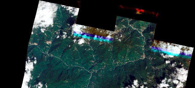
NASA have manage to collect a satellite image of the earthquake affected area around Sikkim in northern India, recently affected by the M-6.9 earthquake. This is quite a feat given that we are in the tail end of the monsoon season, when clouds are abundant in this area. The news reports and photos from the site have suggested multiple landslide occurrence in the earthquake, so of course an image is a good way to look at this. The image is a 10 m spatial resolution ALI image, which produces a product that looks like an aerial photograph, and thus is easy to interpret.
On the top of the image shown in the image below, there is a quite high incidence of landslides in the valleys. So lets take a look at one of these areas. First, one’s eye is certainly drawn to the landslides in the northwest corner.
There are many landslides! A few things to note – first, most of the slides appear to the on the slopes that face towards the east and the south, there are few on the slopes that face to the west. The epicentre was about 45 km to the northwest of this location, so this directionality is of real interest, and personally I am slightly surprised by the fact that the slopes that failed were those orientated way from the epicentre, not towards it. Second, most of the slides appear to be shallow rockslides that have connected to the gully systems; many of them have initiated high on the hillside. There are also some large slides nearer to the main channels.
Of course, a question that must always be asked is whether these landslides were triggered by the earthquake. There is a Google Earth image of this area from 2007, shown below. It is not great quality, but good enough to see that these landslides were not present at that time. It is likely, given the directionality of the landslides, and the fact that they are clearly very fresh, that the majority were triggered by the earthquake. However, it is also possible that some were triggered by a monsoon rainfall event ahead of the earthquake.
I will try to post again on the area of the image to the east of the above, which also has many landslides. It will be fascinating to take a look at the area off this image to the northwest – i.e. around the epicentre in the really high mountains. This is where any really large landslides are likely to be located.
We encourage our readers to read regularly Dave Petley "The Landslide Blog", probably the best in the world!
Copyright Dave Petley and "The Landslide Blog"


