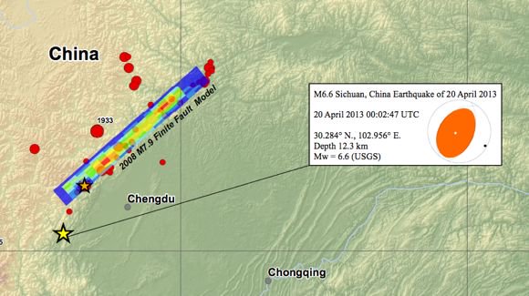
The April 20, 2013 UTC Mw6.6 earthquake in the Sichuan province of China occurred as the result of east-west oriented reverse-type motion on a north-south striking fault.

A preliminary source location suggest the event likely occurred on the Longmenshan fault or a tectonically related fault at a depth of 12km.
The Longmenshan fault was the source fault of the May 12, 2008 Mw7.9 Sichuan earthquake.

The preliminary April 20 event location is approximately 85 km from the hypocentral location of the 2008 Sichuan earthquake.
The April 20 earthquake reflects tectonic stresses resulting from the convergence of crustal material slowly moving from the high Tibetan Plateau, to the west, against strong crust underlying the Sichuan Basin and southeastern China.
On a continental scale, the seismicity of central and eastern Asia is a result of northward convergence of the India plate against the Eurasia plate with a velocity of about 50 mm/y. The convergence of the two plates is broadly accommodated by the uplift of the Asian highlands and by the motion of crustal material to the east away from the uplifted Tibetan Plateau.
Four events of Mw6.0 or greater have occurred within 200km of the April 19 event in the past 40 years, including the May 2008 Sichuan earthquake and a subsequent aftershock. The northwestern margin of the Sichuan Basin has previously experienced destructive earthquakes.
The magnitude 7.5 earthquake of August 25, 1933, killed more than 9,300 people, while the May 12, 2008 killed 69,197.
I think there might be a typing mistake in the above description, in the second paragraph: resulting from the convergence of crustal material slowly moving from the high tibetan plateau, to the WEST: shouldn't this be to the EAST? or am i mistaken?
Thank you for sharing your information on earthquakes.
Nina