– Written by Armand Vervaeck, James Daniell and Jens Skapski
Understanding the tectonics behind the Southern Iran earthquake
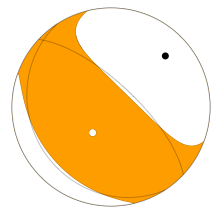
Focal mechanism of this earthquake
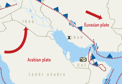
The April 9, 2013 M6.3 earthquake in southern Iran occurred as result of northeast-southwest oriented thrust-type motion in the shallow crust of the Arabian plate.
The depth and style of faulting in this event are consistent with shortening of the shallow Arabian crust within the Zagros Mountains in response to active convergence between the Arabian and Eurasian plates. Because this event is an intraplate event, occurring almost 300 km south of the main plate boundary, and since the event likely did not break the surface, precise identification of the causative fault is difficult at this time.On a broad scale, the seismotectonics of southern Iran are controlled by active convergence between the Arabian and Eurasian tectonic plates. This motion manifests in two ways: subduction in the Makran which stretches from the mouth of the Persian Gulf eastward into Pakistan, and continental collision in the Zagros Mountains, which stretch from the Makran northward into Iraq and Turkey.
The April 9 event occurred within the Zagros fold-and-thrust belt - the portion of the Zagros Mountains that border the north shore of the Persian Gulf. At the latitude of the event, convergence rates between Arabia and Eurasia are approximately 30 mm/yr. The Zagros Mountains experience high rates of seismicity, with thrust-type events similar to the April 9 earthquake and right-lateral strike slip events common. Recent thrust-type events as large as M6 have occurred south of the April 9 epicentral area in the Bandar-e-Abbas region. Highly damaging events such as the 2003 M6.6 Bam earthquake occurred outside of the Zagros Mountains, north of the Makran subduction zone, 660 km to the east of the April 9 event. While the Zagros region experiences high rates of seismicity, large (>M7) surface rupturing earthquakes here are rare.
Over the past 40 years, 5 events of M6 or greater have occurred with 300 km of the April 9 earthquake. The closest was an M6.1 right-lateral strike slip event on March 1, 1994, which killed approximately 50 people.Image courtesy and copyright : gulfnews.com
Important update about NON-SCIENTIFIC earthquake prediction websites
The following should also be published in addition to the comment below in order to reduce some of the misinterpretations of a potential large earthquake that have been put up on the Iranian Facebook:-
"I must comment on this as this applies to my profession. Please consider that the best science cannot yet come up with a reliable prediction (specification of time, location and magnitude) of an earthquake. The site you link does not attempt to do this either, only stating there is a high likelihood of aftershocks in Iran. Given the large earthquake of yesterday, the occurrence of aftershocks are to be expected. However, the size of these aftershocks matters which can be larger than the main shock. We do not know this beforehand. In anycase, I looked through the link and there is no information on their "statistical methods" that I could find. My only request is not to misinterpret this or other information. There is no "Center for Global Earthquake Reporting - مرکزه لرزه نگاری جهانی" as implied in the Status; there is no reliable way of predicting earthquakes; and the best practice is to expect aftershocks on the fault where the earthquake occurred yesterday over the next few days or weeks." - Dr. B. Khazai, CEDIM, Karlsruhe, Germany.
مرکزه لرزه نگاری جهانی می گوید تا 48 ساعت آینده زلزله های بزرگی در ایران رخ می دهد !
http://www.world-earthquakes.com/index.php?option=ethq_prediction - we do not agree with this.
Update 16:52 UTC : 40 killed (2 twins were stuck under the debris but have been unharmed) and 1100 injured. Many buildings have also been damaged by aftershocks - 3100 in total are showing some form of damage.
Update 16:18 UTC : Unofficial statementas are currently mentioning a death toll of 42.
The governor of Iran’s Bushehr Province says reconstruction operations have begun in the areas of the province that were hardest hit by the recent earthquake, as immediate relief efforts are completed.
Fereydoun Hassanvand said on Wednesday that with the completion of relief and rescue operations in the quake-stricken areas, efforts to repair and rebuild water, power and communications networks in the affected districts of Shanbeh and Tasouj have already gotten underway. (source presstv / Iran)
The leader of Islamic Revolution, Ali Khamenei, following the traumatic earthquake disaster in Bushehr by issuing a message for the victims and survivors of the incident asked for patience and wishing recovery for them.
The text is as follow:
In the Name of God, the Compassionate, the Merciful
With regret and sadness I have received the news of the earth quake in the Bushehr province with its human casualties and devastations.
With prayer, I am asking for God’s mercy and forgiveness for the deceased and healing, patience and reward for the victims and survivors.
I would like to ask the honorable representative of the Supreme leader and respected province authorities, as well as government authorities [in Tehran] to use all your efforts to rescue the victims and to support and help the survivors.
I hope our beloved people from all over the country as always play their brilliant role to alleviate the suffering of the disaster victims.
Peace and God's mercy
Sayed Ali Khamenei
20 / April / 1392
UPDATE 11:30 - The death toll remains at 40.
UPDATE 11:30 - We have had a lot of requests and comments about a "prediction of a big earthquake" by www.world-earthquakes.com (we refuse to link to this website).
We would like to say to the public that although there is ALWAYS a minor chance of such an earthquake occurring there is A VERY LARGE CHANCE that it will not occur, and not to use such probabilities wrongly in comments on Facebook and Twitter.
There is also NO DOCUMENTATION from such a website.
A site which deals with real-time probabilities of earthquakes openly is http://www.openhazards.com/viewer. Here you will see the probability is much lower.
We would also like to remind our viewers that earthquakes cannot be predicted.
UPDATE 11:00 - At least 40 people have died and 1000 people have been injured as a result of this earthquake according to current government figures. Over 100 of the 1000 injured have been severely injured.
UPDATE 05:18 - Apart from the number of houses destroyed changing upward to 700, there has been good news in that the death toll has not changed from 37.
A very large aftershock of M5.6 struck the same region, however most people should be out of their houses and it is expected that fatalities will be kept to a minimum.
The relief and support given to victims has been commendable and many disaster relief staff and doctors and nurses are on site tending to the 100-150 severely injured.
UPDATE 03:00 - The pictures below are showing the damage in the village of Dashti, Iran. The death toll hasn't changed since our update from yesterday evening.
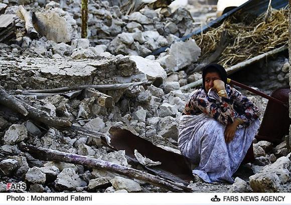
Image courtesy and copyright FARS agency Iran
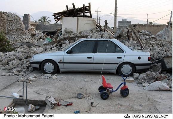
Image courtesy and copyright FARS agency Iran
UPDATE 19:42 - Although Iranian SAR troops (which are highly skilled) will work all night, news will be very limited (based on multiple earlier Iranian earthquakes we have followed). We expect more news tomorrow morning. We will follow events however at regular intervals and will post it whenever it becomes available
UPDATE 18:30 - The death toll has risen by 5 to 37.

image courtesy and copyright pgnews.ir
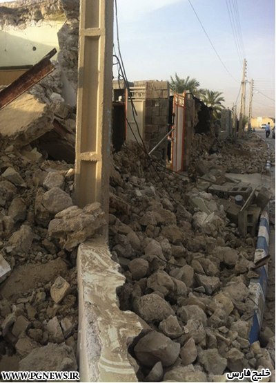
image courtesy and copyright pgnews.ir
SUMMARY 18:00 -
The number of dead: 32 (with 24 bodies currently at the coroners)
The number of severely injured: 100
The number of slightly injured: 750
Pulled from the rubble (rescued): 20
Rescuers on site: 500
Aftershocks so far (significant): 42
There have been 3 villages that have been completely destroyed with the worst being that of Baghani, and another 47 that have some damage with the city of Khormoj having the most. Over 3000 households can be housed in emergency accommodation. So far it has been calculated that around 200 houses have major damage, thus less families are currently in accommodation.
With the cold weather, the main hope is to provide shelter for all people during the night, despite the ongoing aftershocks. Over 1000 tents have been transferred to the region. It is also hoped that the landslides have not engulfed any houses.
No damage has occurred in the oil fields of the Gulf, as well as Bahrain, Saudi Arabia, Dubai, Qatar and Kuwait. They did however have some shaking and it was well felt (thank you for all the felt reports). In addition, there were some high rise buildings that were evacuated as a precaution.
It is of course nighttime now, and more of the destruction will be seen in the morning.
In addition:
“The earthquake in no way affected the normal situation at the [Bushehr nuclear] reactor. Personnel continue to work in the normal regime and radiation levels are fully within the norm,” RIA Novosti quoted an official at Atomstroyexport as saying.
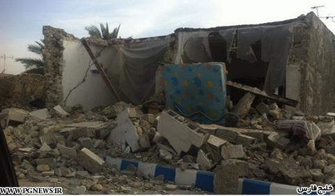
Image courtesy and copyright pgnews.ir
UPDATE 15:34- Number of injured persons rose to 800. In the meantime, Japan and Turkey offered their help for earthquake victims.
 UPDATE 15:02- 31 people were confirmed dead in Bushehr so far.
UPDATE 14:57- 23 villages are affected by the quake, the government says.
UPDATE 14:53- Number of injuries was raised to at least 650. Most of them were transfered to hospital. Rescue teams start to use sniffer dogs to look for spilled people.
UPDATE 14:45- Panic was also created in UAE, Qatar, Bahrain and Saudi-Arabia. People from higher buildings rushed to the streets. Some buildings in Dubai and Abu Dhabi (UAE) were evacuated after the quake.
UPDATE 14:19- No damage has been reported from the oil fields yet, however they have had decent shaking up to MMI IV.
UPDATE 14:13- 500 people are confirmed injured so far. Regional water supply and electricity have been cut off by the quake. More than 1,000 tents have been transferred to Bushehr province.
SUMMARY 14:00- The towns closest to the epicenter have suffered greatly.
- The death toll remains at 12, however is expected to rise in the coming hours.
- Around 40,000 people are affected most of all.
- Landslides were seen.
- A M6.1 earthquake occurred at a depth of 10km in the sparsely populated Bushehr/Kaki region.
- The Bushehr nuclear facility is running smoothly.
- Rescue teams continue to work on retrieving bodies and rescuing survivors from the masonry rubble.
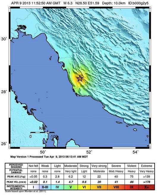
Shaking map
UPDATE 13:49- There are currently 100 rescuers on the scene. According to the rescuers, the towns of Baghani and Senate (bad Farsi translations) in Khormoj have been 100% destroyed (it is still unclear whether the entire village has been destroyed or just some buildings). There are fatalities and injuries that are expected.
UPDATE 13:41- It is as yet unclear if any houses have been affected by the major landslides and rockfalls that have occurred in the mountains.
UPDATE 13:36- The 4 closest villages are currently being assessed. Certain routes (like the highway) closest to the earthquake-stricken areas are closed. This earthquake is rated as CATDAT Red, and is unlikely to be CATDAT Dark Red.
UPDATE 13:33- Some of the aftershocks will also be lightly felt in Saudi Arabia, Bahrain, Kuwait, United Arab Emirates and Qatar. It is quite likely however that no greater earthquakes will occur than the 6.1 that occurred earlier. The quake triggered panic in Dubai’s high-rise buildings and residents rushed out (it is unclear whether any injuries resulted). Some buildings in the Dubai Marina area have been evacuated and workers sent home according to Gulf News sources.
UPDATE 13:30- Villages in Kaki and closer have some homes that have suffered 100% destruction (collapsed according to the Iran classification). These are likely to be of masonry and it can be expected that a 5-15% fatality rate occurs in these buildings.
UPDATE 13:27- At least 12 people are reported dead.
UPDATE 13:23- The death toll has risen to 5. There are scenes of destruction in Kaki, with many destroyed houses being reported. In addition damage in Borozjan Bushehr and also Khormoj. The arrival of teams from Fars and Bushehr will allow for a better range of fatality information soon. The theoretical USGS PAGER model predicts around 200 fatalities as a median (35% chance between 100-1000 fatalities), so there is a high likelihood that a higher number of fatalities will occur than currently reported.
UPDATE:- Many aftershocks have hit the region. The death toll remains at 3, however is expected to rise.
UPDATE:- The Bushehr nuclear facility (around 100km from the quake) is functioning normally.
UPDATE:- 20 rescue personnel in 4 assessment teams, and 2 helicopters have been sent. Kaki city has some destroyed houses, and some poorly built rural houses in Bushehr (around 50-60km away) have cracking. It is expected that Kaki and Khormoj will have the most destruction.
UPDATE:- Kaki city actually has 10,000 people. Thus, there is more exposure than first thought. Unfortunately, death rates of around 2-3% are not uncommon from such earthquakes. Red Crescent assessment teams have been sent to the scene.
UPDATE:- The Siraj highway is quite close to the epicenter and around 16-22km from Khormoj. 3 people have died, and there are helicopters and assistance being sent to the region. In addition, many landslides have been seen.
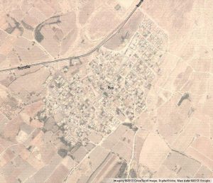
UPDATE:- The earthquake has occurred near the Borozjan fault, near a salt dome. There appears to be a town of around 2000 people from satellite images that is close to the earthquake epicenter. Good news is that it is further from Khormoj than first expected from the Iran epicenter.
UPDATE:- Finally news, from the earthquake epicenter where a M6.1 earthquake (local magnitude by IIEES, Iran) - there has been damage reported in Kaki County. In addition, there are scattered reports of possible casualties.
UPDATE:- It is generally bad news in Iran as there are no reports from ISNA, IRNA or Fars News currently on the earthquake. All major agencies have given a shallow 6.2 to 6.3 earthquake (GEOFON, USGS and EMSC). It is expected however that the earthquake may be slightly deeper than first thought which may reduce fatalities. Iran has a very low Q value, meaning that generally earthquake waves reduce in energy (attenuate) faster with distance.
UPDATE:- Many towers have been evacuated across Dubai and in the Middle East given the light shaking. The area of main concern however is the epicentral region. Bushehr at 90km from the epicenter should have been spared major damage, but the closer towns probably not.
UPDATE:- A M5.4 aftershock has also occurred, which will have added to the possible damage.
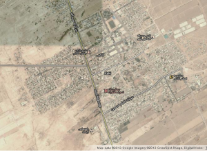
UPDATE:- There are approximately 3000 people living in the intensity 8 shaking zone according to the USGS PAGER model and 15000 people in the intensity 7 shaking zone. Khvormuj is a city in and capital of Dashti County, Bushehr Province, Iran. At the 2006 census, its population was 31,667, in 6,966 families. It is around 25km away from the epicenter.
A strong earthquake has been felt across the region. Magnitude 6.2 in southern Iran can often cause major damage especially when at a shallow depth. It is worth remembering that the 2003 Bam earthquake had a magnitude around 6.5, and caused around 25,000 deaths.
A M6 earthquake struck the same region of Khormoj in 1976 on the 22nd of April causing some damage but no fatalities.
It has been felt intensity IV in Dubai (probably long period waves in a high building).
This current earthquake has been felt in Bahrain, Qatar, UAE and Saudi Arabia.
Most important Earthquake Data:
Magnitude : 6.1 (IIEES Local), 6.3Mw (USGS Global)
Local Time (conversion only below land) : 2013-04-09 16:22:51
GMT/UTC Time : 2013-04-09 11:52:51
Depth (Hypocenter) : 12 km, 10km
Depth and Magnitude updates in the list below.
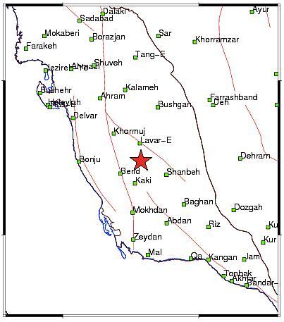
Image courtesy Iranian Seismological Center
Share your earthquake experience (I Have Felt It) with our readers.
Click on the "I Felt It" button behind the corresponding earthquake. Your earthquake experience is not only important for science, but also for people in the area as well as our global readership.
| Refresh this list | ||||||
| SRC | Location | UTC Date/time | M | D | INFO | |
| EMSC | Southern Iran | Apr 09 23:34 | 4.3 | 10 | MAP I Felt It INFO | |
| USGS | Southern Iran | Apr 09 23:33 | 4.2 | 10 | MAP | |
| EMSC | Southern Iran | Apr 09 23:19 | 3.8 | 8 | MAP | |
| EMSC | Southern Iran | Apr 09 23:12 | 3.7 | 10 | MAP | |
| EMSC | Southern Iran | Apr 09 22:51 | 3.6 | 36 | MAP I Felt It INFO | |
| EMSC | Southern Iran | Apr 09 22:36 | 3.7 | 18 | MAP | |
| EMSC | Southern Iran | Apr 09 22:23 | 3.7 | 15 | MAP I Felt It INFO | |
| EMSC | Southern Iran | Apr 09 22:20 | 4.0 | 25 | MAP | |
| EMSC | Southern Iran | Apr 09 22:15 | 3.7 | 18 | MAP I Felt It INFO | |
| EMSC | Southern Iran | Apr 09 21:53 | 4.5 | 15 | MAP | |
| GEOFON | Southern Iran | Apr 09 21:53 | 4.6 | 10 | MAP | |
| USGS | Southern Iran | Apr 09 21:53 | 4.4 | 10 | MAP | |
| EMSC | Southern Iran | Apr 09 21:41 | 3.6 | 19 | MAP | |
| EMSC | Southern Iran | Apr 09 21:18 | 4.1 | 2 | MAP | |
| GEOFON | Southern Iran | Apr 09 21:18 | 4.3 | 10 | MAP | |
| USGS | Southern Iran | Apr 09 21:18 | 4.1 | 10 | MAP I Felt It INFO | |
| EMSC | Southern Iran | Apr 09 21:01 | 4.0 | 2 | MAP I Felt It INFO | |
| EMSC | Southern Iran | Apr 09 20:54 | 4.9 | 10 | MAP | |
| GEOFON | Southern Iran | Apr 09 20:54 | 4.9 | 10 | MAP | |
| USGS | Southern Iran | Apr 09 20:54 | 4.8 | 9 | MAP | |
| EMSC | Southern Iran | Apr 09 20:06 | 4.6 | 17 | MAP I Felt It INFO | |
| GEOFON | Southern Iran | Apr 09 20:06 | 4.7 | 10 | MAP | |
| USGS | Southern Iran | Apr 09 20:06 | 4.6 | 19 | MAP | |
| EMSC | Southern Iran | Apr 09 19:51 | 3.5 | 18 | MAP I Felt It INFO | |
| EMSC | Southern Iran | Apr 09 19:37 | 3.8 | 14 | MAP | |
| GEOFON | Southern Iran | Apr 09 19:10 | 4.4 | 10 | MAP | |
| EMSC | Southern Iran | Apr 09 19:10 | 4.4 | 30 | MAP I Felt It INFO | |
| USGS | Southern Iran | Apr 09 19:10 | 4.4 | 10 | MAP | |
| USGS | Southern Iran | Apr 09 18:59 | 4.3 | 10 | MAP | |
| GEOFON | Southern Iran | Apr 09 18:59 | 4.4 | 10 | MAP | |
| EMSC | Southern Iran | Apr 09 18:59 | 4.3 | 5 | MAP | |
| EMSC | Southern Iran | Apr 09 18:46 | 3.8 | 17 | MAP I Felt It INFO | |
| EMSC | Southern Iran | Apr 09 18:03 | 3.9 | 12 | MAP I Felt It INFO | |
| EMSC | Southern Iran | Apr 09 17:27 | 3.7 | 23 | MAP | |
| GEOFON | Southern Iran | Apr 09 17:21 | 4.3 | 10 | MAP I Felt It INFO | |
| USGS | Southern Iran | Apr 09 17:21 | 4.4 | 9 | MAP | |
| EMSC | Southern Iran | Apr 09 17:21 | 4.4 | 12 | MAP I Felt It INFO | |
| EMSC | Southern Iran | Apr 09 16:32 | 4.7 | 10 | MAP | |
| GEOFON | Southern Iran | Apr 09 16:32 | 4.6 | 10 | MAP I Felt It INFO | |
| USGS | Southern Iran | Apr 09 16:32 | 4.7 | 10 | MAP | |
| EMSC | Southern Iran | Apr 09 16:27 | 3.6 | 23 | MAP | |
| EMSC | Southern Iran | Apr 09 16:20 | 3.7 | 30 | MAP | |
| EMSC | Southern Iran | Apr 09 15:26 | 3.6 | 34 | MAP I Felt It INFO | |
| EMSC | Southern Iran | Apr 09 15:17 | 3.8 | 18 | MAP | |
| EMSC | Southern Iran | Apr 09 15:05 | 4.2 | 10 | MAP | |
| GEOFON | Southern Iran | Apr 09 15:05 | 4.5 | 10 | MAP | |
| USGS | Southern Iran | Apr 09 15:05 | 4.2 | 10 | MAP | |
| EMSC | Southern Iran | Apr 09 14:48 | 3.9 | 12 | MAP I Felt It INFO | |
| EMSC | Southern Iran | Apr 09 14:44 | 4.8 | 20 | MAP | |
| GEOFON | Southern Iran | Apr 09 14:44 | 5.0 | 14 | MAP | |
| USGS | Southern Iran | Apr 09 14:44 | 4.8 | 10 | MAP | |
| EMSC | Southern Iran | Apr 09 14:22 | 3.7 | 35 | MAP | |
| EMSC | Southern Iran | Apr 09 14:16 | 3.6 | 33 | MAP | |
| EMSC | Southern Iran | Apr 09 14:00 | 3.5 | 33 | MAP I Felt It INFO | |
| EMSC | Southern Iran | Apr 09 13:42 | 3.6 | 36 | MAP | |
| EMSC | Southern Iran | Apr 09 13:36 | 4.0 | 18 | MAP | |
| EMSC | Southern Iran | Apr 09 13:30 | 4.7 | 10 | MAP | |
| GEOFON | Southern Iran | Apr 09 13:30 | 4.8 | 15 | MAP I Felt It INFO | |
| USGS | Southern Iran | Apr 09 13:30 | 4.8 | 10 | MAP I Felt It INFO | |
| GEOFON | Southern Iran | Apr 09 13:03 | 4.6 | 15 | MAP | |
| EMSC | Southern Iran | Apr 09 13:03 | 4.5 | 15 | MAP | |
| USGS | Southern Iran | Apr 09 13:03 | 4.2 | 10 | MAP I Felt It INFO | |
| EMSC | Southern Iran | Apr 09 12:58 | 3.7 | 15 | MAP | |
| EMSC | Southern Iran | Apr 09 12:52 | 4.0 | 37 | MAP | |
| GEOFON | Southern Iran | Apr 09 12:47 | 4.8 | 15 | MAP | |
| EMSC | Southern Iran | Apr 09 12:47 | 4.7 | 30 | MAP | |
| USGS | Southern Iran | Apr 09 12:47 | 4.7 | 10 | MAP | |
| EMSC | Southern Iran | Apr 09 12:41 | 4.8 | 10 | MAP | |
| USGS | Southern Iran | Apr 09 12:41 | 4.7 | 10 | MAP | |
| GEOFON | Southern Iran | Apr 09 12:41 | 4.8 | 10 | MAP I Felt It INFO | |
| EMSC | Southern Iran | Apr 09 12:31 | 4.1 | 18 | MAP | |
| EMSC | Southern Iran | Apr 09 12:18 | 4.2 | 36 | MAP | |
| EMSC | Southern Iran | Apr 09 12:15 | 4.4 | 26 | MAP | |
| GEOFON | Southern Iran | Apr 09 12:05 | 5.4 | 10 | MAP | |
|
|
||||||
| EMSC | Southern Iran | Apr 09 12:05 | 5.4 | 10 | MAP | |
| USGS | Southern Iran | Apr 09 12:05 | 5.4 | 10 | MAP | |
| GEOFON | Southern Iran | Apr 09 11:52 | 6.4 | 14 | MAP | |
|
|
||||||
| EMSC | Southern Iran | Apr 09 11:52 | 6.3 | 10 | MAP I Felt It INFO | |
|
|
||||||
| USGS | Southern Iran | Apr 09 11:52 | 6.3 | 10 | MAP | |
| Fast EARTHQUAKE and TSUNAMI TWEETS @ your MAGNITUDE choice | |||
 |
|||
Other earlier earthquakes in the greater epicenter area (since 2012)
Strongest earthquakes Magnitude 3.5 or more within a 150 km radius from this earthquake (max. 60)

