This is Part 1 of the ICELAND volcanoes activity and eruption report
CLICK HERE TO READ THE LATEST NEWS
You may follow also Facebook Volcano Page - Twitter : @VolcanoReport and @JanineKrippner
Bárðarbunga update August 31 21:48 UTC
* The highest lava fountains are about 70m high. The temperature of the lava is about 1200°C (~2200°F).
* Until scientists downgrade danger of eruption starting under glacier then area north of Bardarbunga will be closed to cars and hikers
* Scientists warn that this cycle of eruptions can last until next year or longer. Great excuse to visit Iceland
* Scientists have revised amount of magma coming up to 250 m3/s - the lava is flowing NE at a rate of 1/2-1 m/minute
After dinner work installing instruments. @Cambridge_Uni @uni_iceland @Vedurstofan pic.twitter.com/9sAHpYY518
— Thorbjorg Agustsdott (@fencingtobba) August 31, 2014
Bárðarbunga update August 31 21:01 UTC
WOW, what a show now at the webcam now. http://www.livefromiceland.is/webcams/bardarbunga-2/
Bárðarbunga update August 31 20:41 UTC
And finally a great video recorded by Rob Green, one of the people who have the great task to do field work (yes, we are jealous 🙂
Bárðarbunga update August 31 20:34 UTC
31st August 2014 18:21
Few additional facts since status report earlier today:
* Now about 700 earthquakes have been detected since midnight.
* An earthquake M4.9 occurred at 16:12 on the northern rim of the Bárðarbunga caldera.
* The main seismic activity has been in the intrusive dike. Only a few quakes have been located near the caldera rim, mostly its northern part.
* Little seismic activity has been near Askja but some seismic activity near Herðubreiðartögl.
* Weather conditions; very windy (Yes, we know that - we are almost seasick 🙂
Bárðarbunga update August 31 20:30 UTC
Sequence at 10:15 UTC on Sunday August 31 2014 - The length of the fissure was approx. 1.5 km and the lava flow was calculated at 1000 cubic meter per second. Lava fountains and flowing Pahoehoe lava is clearly visible on this video and is reaching a maximum height of 60 meter - Video courtesy Mila, livefromIceland.is webcam
Bárðarbunga update August 31 17:10 UTC
Acceptable "still" Mila webcam picture from the fissure eruption made a couple of minutes ago.
Watching the LIVE webcam will make you more seasick than a cruise journey on the oceans 🙂
Bárðarbunga update August 31 17:07 UTC
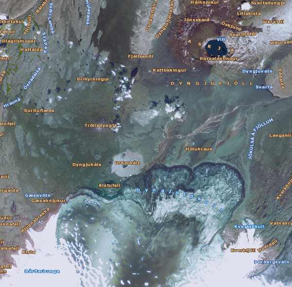
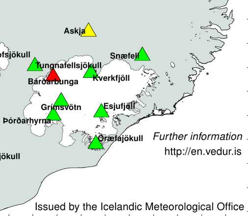
In our category "nice to know" (Askja is a volcano to the North-West of Bardarbunga - see map below)
In 1965 & 1967, our geologists trained #Apollo astronauts in #Askja. Here they are walking in pumice from 1875 pic.twitter.com/GQYfDw1Nc2
— Univ. of Iceland (@uni_iceland) August 31, 2014
Bárðarbunga update August 31 16:47 UTC
31st August 2014 14:45 - from meteorologist on duty
Visibility to the eruption site is now good. No ash has has been detected. The Aviation Color Code for Bárðarbunga has therefore been reset to ‘orange' and the code for Askja is still at ‘yellow'.
Bárðarbunga update August 31 16:00 UTC
31st August 2014 12:07 - from the Scientific Advisory Board
Scientists from the Icelandic Met Office and the Institute of Earth Sciences and representatives of the Civil Protection in Iceland attend the meetings of the Scientific Advisory Board of the Icelandic Civil Protection.
Conclusions of the Scientific Advisory Board of the Icelandic Civil Protection:
* A lava eruption started in Holuhraun shortly after 04 AM, on the same volcanic fissure, which erupted earlier this week. The fissure is estimated to be 1,5 km long. It was detected on Míla´s web-camera at 05:51 AM.
* Fewer earthquakes seem to follow the event than in the previous eruption, but more lava is being extruded.
* At 07 AM the lava flow was around 1 km wide and 3 km long towards northeast.
* The thickness was estimated a few meters, the flow about 1000 m3 pr second.
* Approximately 500 earthquakes were detected in the area and smaller than before. The strongest earthquake, M3.8 was in the Bárðarbunga caldera. Poor weather conditions prevail in the area, which makes detection of smaller earthquakes difficult.
* GPS measurements show continued movements north of Dyngjujökull.
* Gas emissions rise to a few hundred meters above the fissure.
* Weather conditions make it difficult to follow the progression of the eruption, but scientists are in the area, using every opportunity to acquire information on gas and lava outflow.
* Weather conditions do not allow overflight at this time. The opportunity to fly over the area will be assessed later today.
From the Icelandic Met Office:
* The Aviation Colour Code for Bárðarbunga is at ‘red' and the code for Askja at ‘yellow'.
Bárðarbunga update August 31 13:12 UTC
A lot of people are still struggling with the location of the Holuhraum eruption site versus the Bardarbunga, Kverkfjoll and Askja volcanoes. The map below shows them all 4
Bárðarbunga update August 31 13:12 UTC
@subglacial ash being reported in Akureyri - seems unlikely to be from #Bardarbunga given current eruption. More likely remobilised by wind?
— Matthew Watson (@Matthew__Watson) August 31, 2014
Bárðarbunga update August 31 13:07 UTC
- The eruption started around 0400. Lava is flowing at around 1000 m3/s and is 1kmx3km wide. Still ongoing
- The stronger earthquakes are still happening outside the erupting fissure area, at the Bardarbunga caldera. A little earlier the strongest one today, with a preliminary value of 4.8. (Update : IMO reports a M5.1 at a depth of 5.2 km - IMO has a lot of instruments in the area and will have always the best results in Iceland (this message for those among you who think that USGS is always the most accurate 🙂 ))
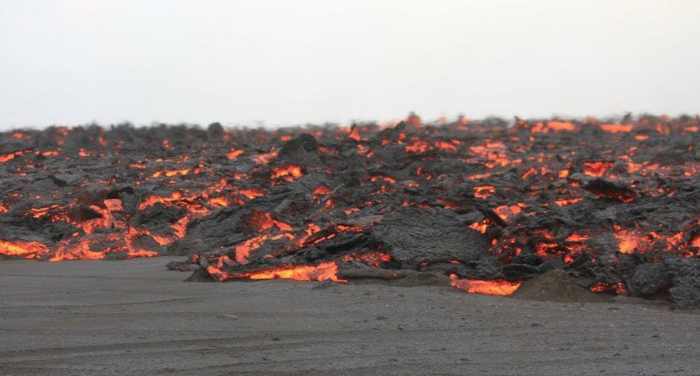
- Below an image from the University of Iceland of the fresh Pahoehoe lava
Bárðarbunga update August 31 12:34 UTC
Okay, we agree that the video below which we captured from the Mila Bardarbunga 2 webcam in a rare moment of relative clarity is not what we want, but at least you can clearly see the lava fountains dancing in the wind. They are spouting up to 60 meters high (the webcam has a big zoom)
Bárðarbunga update August 31 11:03 UTC
The image below shows the risks scientists are taking in coming as near as possible to the eruption site. In a fissure eruption nobody knows where exactly the fissure will surface. It is a calculated risk of course but a calculation with a number of unknown parameters. Must be a literally thrilling sensation.
A scientific report will arrive soon (scientific committee meeting now)
Bárðarbunga update August 31 10:27 UTC
@almannavarnir : Fissure est. 1.5 km with lava flowing 3 km east, lava fountains. Now a storm is going over the area and very low visibility.
New fissure eruption at Holuhraun. We had to retreat due to sandstorm. Managed to rescue seismometer. @Cambridge_Uni @uni_iceland
— Thorbjorg Agustsdott (@fencingtobba) August 31, 2014
Bárðarbunga update August 31 10:25 UTC
I am again obliged to cut a part of this article as Bardarbunga and Tavurvur made it too long, but extremely interesting at the same time.
August 27 and 28 have now been archived - see link below to consult it
Bárðarbunga update August 31 09:52 UTC
Pahoehoe lava (Yes, the Hawaiian type and name) flow this morning, in Iceland also called "helluhraun". Pictures by Ármann Höskuldsson via @uni_iceland
For those who not know the lava types - 2 main categories a) Pahoehoe lava (smooth, unbroken) and b) AA lava (very brittle)
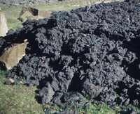 AA lava |
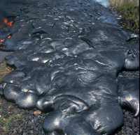 Pahoehoe lava |
These images were taken by scientists who were very close to the fissure location. They have now pulled back because of the bad weather. Fire fountains go as high as 60 meters.
Bárðarbunga update August 31 09:36 UTC
- Weather conditions in the Holuhraun #eruption area make it difficult for everyone to monitor progress. Scientists have left the area.
- The fissure is about 1.5 km long, fire up to 60m in the air. Still no threat. Fly ban only up to 6000 feet.
- Domestic flights have been grounded due to weather conditions, not the eruption.
The scientific advisory council of @almannavarnir is meeting at 10am GMT to discuss developments in #Holuhraun & #Bardarbunga
— Gisli Olafsson (@gislio) August 31, 2014
Bárðarbunga update August 31 08:44 UTC
NO science updates since yesterday
Scientists from IMO were installing additional sensors in the area near Holuhraun yesterday evening
Tremor is of course higher than before the eruption
The University of Iceland had analyzed the lava from the first eruption (same kind of lava now). Click here for details.
Scientists say "fissure longer than before.. picture below is from Benni" who was installing instrument
Bárðarbunga update August 31 08:03 UTC
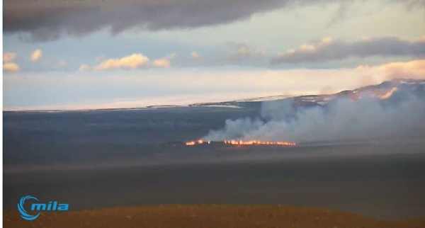
If you cannot link to the Mila webcam, you are certainly not the only one. The network is once again saturated.
Part of the Icelandic air space is again forbidden to fly over. The ash emission from the fissure eruption is limited but nevertheless it could suddenly increase of course.
Travellers do NOT need to worry about #Holuhraun #eruption near #Bardarbunga - airspace closure is just around the eruption site #aviation
— Gisli Olafsson (@gislio) August 31, 2014
Bárðarbunga update August 31 06:27 UTC
This morning a new fissure eruption started in the same Holuhraun area as the first one. The webcam view is often obscured by the dand and dust in front of the fissure area. We expect the length of the fissure to be a little longer than the first one
Bárðarbunga update August 30 22:13 UTC
30th August 2014 18:34 - from geoscientist on duty
Over 1100 earthquakes have been detected since midnight 29/30 August until 18:30; the vast majority in the northern part of the dyke intrusion, see maps.
As this morning, the active part of the dyke intrusion extends from about 4 km south of the glacier margin of Dyngjujökull to the location of yesterday's fissure eruption. There is no sign of northwards migration of the intrusion.
No large events (M>4) have been detected near the Bárðarbunga caldera since this morning. One event of M2.1 was detected at the northern caldera rim at 13:40. Few small events were detected around Askja volcano.
Summarizing, no significant changes in seismic activity have been observed.
Bárðarbunga update August 30 14:18 UTC
WOW!, thats what we say after watching a great NEW 3D seismic model from IMO - It visualizes the depth of the earthquakes and highlights the activity spots. Congratz to IMO Iceland for this great tool!. Click here and enjoy playing with it.
Bárðarbunga update August 30 13:10 UTC
30th August 2014 11:45 - from the Scientific Advisory Board
Scientists from the Icelandic Met Office and the Institute of Earth Sciences and representatives of the Civil Protection in Iceland attend the meetings of the Scientific Advisory Board of the Icelandic Civil Protection.
Conclusions of the Scientific Advisory Board of the Icelandic Civil Protection:
* Earthquake activity continues on a 15-km-long region of the dyke intrusion, extending both into the Dyngjujökull glacier and the region north of the ice margin.
* Earthquakes have not migrated northwards during the last two days.
* Seismicity remains high and, since midnight, about 700 earthquakes have been detected in the region.
* The largest earthquakes since midnight include: (i) a magnitude 4.5 event on the northern side of the Bárðarbunga caldera at 02:35 UTC; (ii) a magnitude 4.2 earthquake in the same region at 06:18 UTC; and (iii) a magnitude 5.4 earthquake on the south-eastern edge of the Bárðarbunga caldera at 07:03 UTC.
* During the last two weeks, several earthquakes of similar size have occurred on the edge of the Bárðarbunga caldera. These earthquakes are interpreted as signs of stress changes in the region of the caldera.
* Over 20 micro-earthquakes have been detected in the Askja region. It is thought that these earthquakes have occurred due to stress changes north of the dyke intrusion.
* GPS measurements show continued horizontal movements north of Vatnajökull due to formation of the dyke intrusion on the northern edge of the ice-cap.
* No unusual changes in the discharge or electrical conductivity of Jökulsá á Fjöllum have been detected. The same applies to other rivers draining from north-western Vatnajökull.
* A sample of newly erupted lava was taken from Holuhraun yesterday; analysis is ongoing.
There are no indications that the intensity of the activity declining.
At this moment it is unclear how the situation will develop. However, four scenarios are considered most likely:
*** The migration of magma could stop, resulting in a gradual reduction in seismic activity and no further eruptions.
*** The dike could reach the Earth's surface north of Dyngjujökull causing another eruption, possibly on a new fissure. Such an eruption could include lava flow and (or) explosive activity.
*** The intrusion reaches the surface and an eruption occurs again where either the fissure is partly or entirely beneath Dyngjujökull. This would most likely produce a flood in Jökulsá á Fjöllum and perhaps explosive, ash-producing activity.
*** An eruption in Bárðarbunga. The eruption could cause an outburst flood and possibly an explosive, ash-producing activity. In the event of a subglacial eruption, it is most likely that flooding would affect Jökulsá á Fjöllum. However it is not possible to exclude the following flood paths: Skjálfandafljót, Kaldakvísl, Skaftá and Grímsvötn.
Other scenarios cannot be excluded.
From the Icelandic Met Office:
The Aviation Colour Code for Bárðarbunga remains at ‘orange' and the code for Askja at ‘yellow'.
Bárðarbunga update August 30 11:12 UTC
Scientists say this activity in/near Bardarbunga may last years like Krafla eruptions did in 1975-84 Source : Gisli Olafsonn, Civil Protection Iceland
Bárðarbunga update August 30 11:01 UTC
Great picture of the ash fallout after historic eruptions of the Bardarbunga volcano. Wind direction is of course the most important reason the ash loads landed in different areas. Some thicknesses are really spectacular and reach as far as Reykjavik. These eruption where eruptions of the volcano itself, no fissure eruptions like we witnessed earlier this week. Map via a tweet from John A Stevenson alias @volcan01010
Bárðarbunga update August 30 07:57 UTC
30th August 2014 07:20 - from geoscientist on duty
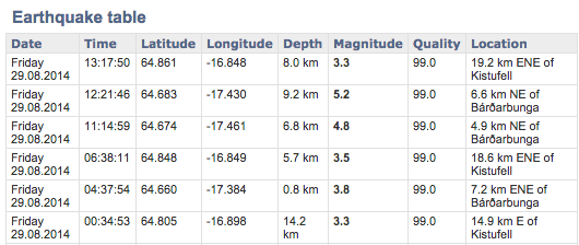
Around 450 earthquakes have been detected since midnight 29/30 August until 07:00, the vast majority in the northern part of the dike intrusion, see map below.
The active part of the dike intrusion extends from about 4 km south of the glacier margin of Dyngjujökull to the location of yesterday's fissure eruption. Only a few small earthquakes have been located north of the eruption site and there is no sign now of northwards migration of the intrusion. Strongest events in this area were M2.7 at 03:01 and M2.8 at 06:19.
Several events have been detected on the caldera rim of Bárðarbunga, strongest were M4.5 at 02:35 and M4.2 at 06:18, both on the northern rim. A magnitude M5.4 earthquake occurred at 07:03 at the southern rim of Bárðarbunga caldera. Several events of similar size have occurred around the caldera rim in recent days. They are interpreted as being related to subsidence of the volcano due to volume decrease in the magma chamber beneath.
A few small events were detected around Askja volcano. Summarizing, no significant changes in seismic activity have been observed.
Bárðarbunga update August 30 07:50 UTC
IMO Iceland has now reported a Magnitude of 5.4 at a depth of 2.9 km below Bardarbunga. This is shallower than most of the Bardarbunga edifice earthquakes but not the first one. Thursday there was a M5.0 at 3 km depth in the same area.
Bárðarbunga update August 30 07:29 UTC
New M+5 earthquakes below the glacier.
USGS did report M5.4 but the USGS data have a too big error margin to point to the exact location. At the time of writing the earthquake was not listed yet at IMO.
The map shows 2 epicenters, thats the error margin i was talking about, both points refer to the same earthquake as reported by different seismological agencies
In the meantime the Mila webcams are showing clouds. If something would happen know only locals will hear it and airplanes will see it 🙂
Bárðarbunga update August 29 22:35 UTC
Þorbjörg Ágústsdóttir, a doctoral student in geophysics at the University of Cambridge, was the first person to hold an chunk of the new lava. A lot of analyzing work ahead
Bárðarbunga update August 29 21:42 UTC
29th August 2014 18:30 - from geoscientist on duty
Little changes since the status report, earlier today. An earthquake M4,1 occurred at 16:27 on the northern rim of Bárðarbunga caldera. The number of earthquakes from the automatic network is similar as at the same time yesterday, about 1200 earthquakes.
Bárðarbunga update August 29 17:27 UTC
29th August 2014 16:20 - Status report
Overall assessment from the joint status report 290814 of the Icelandic Met Office and the University of Iceland, Institute of Earth Sciences:
At this moment it is unclear how the situation will develop. However, three scenarios are considered most likely:
* The migration of magma could stop, resulting in a gradual reduction in seismic activity and no further eruptions.
* The dike could reach the Earth's surface north of Dyngjujökull causing another eruption, possibly on a new fissure. Such an eruption could include lava flow and (or) explosive activity.
* The intrusion reaches the surface and an eruption occurs again where either the fissure is partly or entirely beneath Dyngjujökull. This would most likely produce a flood in Jökulsá á Fjöllum and perhaps explosive, ash-producing activity. At 10:00 UTC, IMO changed the Aviation Colour Code for Bárðarbunga to ‘orange', signifying that significant emission of ash into the atmosphere is unlikely.
The aviation colour-code for the Askja volcano remains at ‘yellow'.
Other scenarios cannot be excluded. For example, an eruption inside the Bárdarbunga caldera.
Bárðarbunga update August 29 14:45 UTC
29th August 2014 12:20 - from the Scientific Advisory Board
Scientists from the Icelandic Met Office and the Institute of Earth Sciences, and representatives of the Civil Protection in Iceland, attend the meetings of the Advisory Board.
Conclusions of the Scientific Advisory Board:
* At 00:02 UTC signs of a lava eruption were detected on web camera images from Mila. The web-camera is located at Vaðalda, north-east of the eruption site.
* Around midnight, weak signs of increased tremor were apparent on IMO's seismic stations near to the eruption site.
* At 00:20 UTC scientists in the field from the Icelandic Met Office, Institute of Earth Sciences and Cambridge University confirmed the location of the eruption.
* The eruption occurred on an old volcanic fissure on the Holuhraun lava field, about 5 km north of the Dyngjujökull ice margin. The active fissure was about 600 m in length.
* A small amount of lava drained from the fissure and by around 04:00 UTC, lava flow is thought to have stopped.
* According to seismic data and web-camera imagery, the eruption peaked between 00:40 and 01:00 UTC.
* At the beginning of the eruption, seismic activity decreased, although seismicity has since returned to levels observed in recent days.
* Aerial observations by the Icelandic Coastguard show that only steam is rising from the site of the lava eruption.
* There are no indications that the intensity of the activity is declining.
* At this moment it is unclear how the situation will develop. However, three scenarios are considered most likely:
*** The migration of magma could stop, resulting in a gradual reduction in seismic activity and no further eruptions.
*** The dike could reach the Earth's surface north of Dyngjujökull causing another eruption, possibly on a new fissure. Such an eruption could include lava flow and (or) explosive activity.
*** The intrusion reaches the surface and an eruption occurs again where either the fissure is partly or entirely beneath Dyngjujökull. This would most likely produce a flood in Jökulsá á Fjöllum and perhaps explosive, ash-producing activity.
*** Other scenarios cannot be excluded. For example, an eruption inside the Bárdarbunga caldera.
Bárðarbunga update August 29 14:40 UTC
RED alert has been changed to ORANGE again above the Bardarbunga, Dyngjujökull, Vatnajökull area.
Official statement :
From the Icelandic Met Office:
At 10:00 UTC, IMO changed the Aviation Colour Code for Bárðarbunga to ‘orange', signifying that significant emission of ash into the atmosphere is unlikely. The aviation color-code for the Askja volcano remains at ‘yellow'.
Bárðarbunga update August 29 13:58 UTC
The Icelandic Coast Guard surveillance plane TF-SIF flew over the eruption site this morning.
The crew took the above thermal image of the fissure. According to the Coast Guard, and contrary to initial reports who stated that the fissure was only 100 meters long (based on webcam estimates), the fissure measures 900 meters (3,000 feet) in length and is 5 km (3 miles) from Dyngjujökull, Vatnajökull outlet glacier.
Bárðarbunga update August 29 12:53 UTC
29th August 2014 11:58 - The new eruption in Holuhraun
Below are two photos of the new lava in Holuhraun, 5-10 km north of Dyngjujökull. The photos were taken from TF-Sif, the aeroplane of the Icelandic Coast Guard.
Bárðarbunga update August 29 09:22 UTC
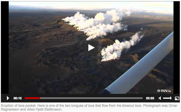
Click on the image below to watch a short video of the overflight of the fissure zone
Bárðarbunga update August 29 09:14 UTC
29th August 2014 07:10 -from geoscientist on duty
* Seismic activity has decreased as a result of the pressure release, however a significant amount of earthquakes is still detected in the magma dike, between the eruption site and south to about 5 km into Dyngjujökull.
* Strongest events were 3.8 in the caldera of Bárðarbunga at 04:37, as well as 2.9 at 05:39 and 3.5 at 06:38 in the dike. These earthquake are very closely monitored, but no significant change volcanic activity following these has been observed so far.
Bárðarbunga update August 29 07:38 UTC
All airports in Iceland are open although an eruption has begun near Vatnajökull.
A recording from a couple of minutes ago at the Mila Bardarbunga 2 webcam
Bárðarbunga update August 29 07:26 UTC
Around 40 #SAR personnel from Landsbjorg providing assistance in closing down all routes to the (dangerous) eruption area Why? Because a dyke can open everywhere in that area, also under your own car or feet Temperature 1200 °C
Bárðarbunga update August 29 06:30 UTC
The fissure is now thought to be 100m long with low lava fountains with thin flowing lava. #Holuhraun
(Zoomed) Image from a couple of minutes ago below Webcam address
Bárðarbunga update August 29 05:22 UTC
Someone captured the eruption on the Mila webcam. This is an image in 1/1, not zoomed like below. We will soon see the size of the fissure during daylight
Bárðarbunga update August 29 04:42 UTC
Below the image right now at the Mila webcam. The camera is zooming in on the eruption spot which explains the quality. Weather is not really good at the moment and it still partly darkness
Bárðarbunga update August 29 04:20 UTC
29th August 2014 02:45 - An eruption north of Dyngjujökull
An eruption started in Holuhraun north of Dyngjujökull at around 00:02.
Seismic tremor was observed on all seismic stations and the web camera installed in the area by Mila has showed some nice pictures of the eruption.
It is a small fissure eruption and at 02:40 AM the activity appears to have decreased.
ER : This is a very small fissure eruption with almost NO ash content, more or less like a few holes in the ground. The area is unpopulated and only the Mila webcam has recorded it.
Bardarbunga update August 20 @ 15:39 UTC
We encourage all our readers to read the linked NATURE article below. ER calls it the most adequate description of a) what is currently happerning and b) which scenarios can happen if it erupts + we fully agree with it. Click here or on the image below to read the full article in the Nature website
Bardarbunga Update August 20 @ 15:13 UTC
National Crisis Center activated
The National Crisis Centre has been fully activated after a decision was taken to evacuate the highlands north of Dyngjujökull (part of Vatnajökull glacier). The area is now closed and has been evacuated. These actions were taken following seismic activity around the Bardarbunga caldera in the last few days.
The area that has now been closed is both large in size and unpopulated. There are still no signs of eruption but these security measures have been taken since it would not be possible to evacuate the area in time should a sub-glacial outburst flood occur from Vatnajökull as a result of an eruption.
In the northwestern part of Vatnajökull glacier the seismic activity is stable, with the main area being northeast of Bardarbunga. Over 300 earthquakes have been detected since midnight. The strongest event was of the magnitude 3.0. Another event happened inside the Bardarbunga caldera and was of the magnitude 2.7.
Today The Coast guard airplane, TF SIF, will make a surveillance flight over the area with scientists and representatives of the Civil Protection unit, if weather conditions allow. Police and ISAR units will enforce the closure of the area. The situation will continue to be closely monitored.
A nice gimmick starts when you click on the picture below. Earthquakes transformed in sound. Try it, earthquakes can make great music 🙂
Bardargunga Update August 20 @ 08:42 UTC
Nothing special to report - still a lot of seismicity but most of it today at a deeper level, average 6 km. The extremely shallow earthquakes (example 1 km) are normally triggered by stress and certainly not by magma intrusion. The Icelandic Met Office still has the following banner above the earthquakes list : Intense earthquake swarm continues at Barðarbunga. Presently there are no signs of magma moving to the surface.
Please keep in mind that normally volcanoes are not interconnected.
Bardargunga Civil Protection report August 19 @ 22:17 UTC
The Police Commissioners of Húsavík and Seyðisfirði have decided to close and evacuate the highlands north of Dyngjujökuls, this due to the continuous earthquakes in the area in recent days. This is a precautionary measure.
The image below is a webcam view of the glacier during the night. The light in the background is the sunrise NOTHING else !
Bardarbunga volcano situation update from Civil Protection Iceland (19/08 at 10:12)
Below the press communique published yesterday by the Iceland Civil Protection.
The situation in Bárðarbunga volcano in NW Vatnajökull glacier has not changed today. The Civil Protection scientists committee held two meetings today with earth scientists from the Icelandic Meteorological Office and the University of Iceland. There is a very strong indication of magma movement east of Bárðarbunga caldera and on the edge of Dyngjujökull near Kistufell. Conductivity is high in Jökulsá á Fjöllum for the time of year.
Around 800 earthquakes have been detected since midnight. The strongest event was at 02:37 of the magnitude 4,5.
Civil Protection is still on Uncertainty Phase, which means that course of events has started that may lead to natural hazard in the near future. The National Commissioner of Icelandic Police (NCIP) has today met with the Prime Minister of Iceland, the Minister of Interior and government officials to consult on the issue. The NCIP also met with officials from the Ministry of Foreign Affairs, foreign embassies in Iceland and from key stakeholders in Iceland.
Mountain roads North of Vatnajökull, F88 (completely) and F910 (partly), have been closed for all traffic. That includes cars, bikes and hiking. A map of the area can be seen here.
Earthquake animation from the seismic activity on August 17 and August 18
Alert level increased to ORANGE for Bardarbunga volcano , Iceland ? (update 18/08 at 13:34 UTC)
Still no eruption, but lets call it that the eruption is imminent and could happen anytime. An eruption does NOT mean a free air eruption as most of the Barbardunga activity kept nicely below the upper part of the glacier (also called subglacial). Some collapsing parts of glacier on top of the the activity location is also possible, just like it happened in 2004 with the eruption of the Grimsvotn volcano. The picture below shows what's happening then - an ice river who might create a jokulhlaup which could lead to Ice rivers with an increased flow and big ice chuncks. These jokulhlaup's are the reason that some roads below the glacier complex have been closed.
More about the pre-eruption phase click here
1240 earthquakes below Bardarbunga volcano , Iceland ? (update 17/08 at 22:00 UTC)
An impressive number of earthquake and a yellow volcano alert because of the seismic activity below the Barbardunga volcano (Vatnajokull complex). Some roads have been closed to traffic out of fear for a Jokullhaup (sudden ice river triggered by the melting ice of the volcano). This normally happens below the massive icecap of the glacier.
The current status of the volcano is YELLOW
These are the possible next alert levels
YELLOW: Volcano is exhibiting signs of elevated unrest above known background level.
ORANGE: Volcano shows heightened or escalating unrest with increased potential of eruption.
RED: Eruption is imminent or in progress - significant emission of ash into atmosphere likely.
Press report from the Iceland Civil Protection
Situation August 17 kl.19: 00
Meetings were held in the morning with the staff the Civil Protection Department, Icelandic Meteorological Office and Earth Sciences rods to review the situation.
The seismic activity is most pronounced in the two clusters north and east Bárðarbunga. No signs are visible that the eruption has started but the seismic activity may be a precursor to an eruption.
Scientists have increased surveillance in the area and police chief in Húsavík, Hvolsvelli and Seyðisfirði plus Vatnajökull National Park are alerted.
Coast Guard helicopter began today with the scientists and staff of the Civil Vatnajökull. That trip did add instruments and webcams as part of increased monitoring of the glacier as well as monitoring changes on the surface of the glacier and the area.
Commissioner of Húsavík has decided to close Gæsavatnaleið and other Highland roads east Skjálfandafljót the caldera. Way to Herðubreiðarlindir F88 (F88) has also been closed due to potential flooding in the area after an eruption.
Eruption in Bárðarbunga volcano, Iceland ? (August 16)
During all last week (Week 33) there has been a minor earthquake swarm in Bárðarbunga volcano. No other activity followed this minor earthquake activity during the week until last night (16-August-2014). During the night (around 02:20 UTC) a harmonic tremor started to appear on SIL stations around Bárðarbunga volcano. Following the appearance of the harmonic tremor earthquake activity started around 03:30 UTC. Largest earthquakes in this swarm have magnitude around 3,0 so far. Depth is around 5 to 10 km. During the night the earthquake swarm moved around in the volcano and is now more east then it first started.
Follow the possible eruption at the website of Jon Frimann, and Icelander who is following up all volcanic and seismic activity below the island
Askja Volcano 22/23 July 2014 Landslide (August 4)
On the night of 23/24 July 2014 (around midnight) there was a large landslide in the SE corner of the steep inner wall of the 1875 AD caldera at the Askja volcano in central Iceland. This event is simply the latest (albeit large and spectacular) of many that have formed the current water-filled caldera of Öskjuvatn (Askja lake). It is part of the ongoing process of the formation of this youngest caldera at Askja, which is after all only 139 years old and which after its initiation in 1875 took several decades (until c.1932) to get close to the shape we see today.
Read the full article here


