On this page : Bardarbunga (Iceland), Kilauea (Hawaii), Sinabung (Indonesia), Cerro Negro (Colombia), Mount Ontake (Japan)
This is an archived part of our Daily Volcano Activity report.
Click here to read the latest part of our report
This report is compiled out of many information sources.
For our El Hierro volcano report : Click here
Hawaii Pahoa update 15:05 UTC
Fighting a #lava flow in Hawaii - http://t.co/818dEzImbm pic.twitter.com/mpn39jBp2W
— The Big Picture (@big_picture) November 4, 2014
May Pahoa, Hawaii escape the misery ?
Scientists of the USGS Hawaiian Volcano Observatory conducted ground observations of the June 27th lava flow throughout the day on Monday, November 3, 2014. The leading edge of the flow has not advanced since Thursday, but active breakouts of lava were present just upslope of the stalled front.
As of 5 PM, HST, the most significant activity was a small finger of lava advancing downslope along the north edge of the private property that the flow entered last week. This lobe was about 160 meters (175 yards) behind the stalled front and was moving parallel to the main (now largely inactive) flow lobe at a rate of 10 meters (11 yards ) per hour since Monday morning. Other areas of persistent breakouts over the past few days were relatively quiet. Minor expansion of the flow field has occurred in the pasture below the Pāhoa cemetery, and there was very little activity in the vicinity of the transfer station.
The summit experienced slight inflation throughout Monday, consistent with the late stages of the most recent DI event.
ER opinion : Escaping misery is not likely we think, but the initial indicated devastation path will normally NOT be followed. The lava feeder has however not stopped and will be breaking out in a number of other lava flows. Nobody knows at this point where that will be. The coming days will tell us in what direction this will be happening. Only the cessation of the current lava breakout in the main crater may save Pahoa all together.
Bárðarbunga update November 3 16:29 UTC
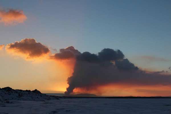
The volcanic eruption in Holuhraun continues with similar intensity.
• Seismic activity in Bardarbunga continues to be strong. Since Friday, 31. October, 207 earthquakes have been detected in the caldera. Two earthquakes were bigger then M5,0, on 31. October at 21:32 an M5,2 earthquake was detected and M5,3 on 2. November at 16:02. In total 27 earthquakes between M4 and 5 were detected and 8 between M3 and 4.
• The GPS station in the centre of Bardarbunga show that the subsidence of the caldera continues with similar rate as it has done over the last few weeks.
• Energy of the geothermal areas in Bardarbunga is now few hundred megawatts and the melting of water is estimated around 2 cubic meters per. second.
• Only 17 smaller earthquakes were detected in the dyke and at the eruption site in Holuhraun since Friday, there off ten from midnight today.
• GPS measurements in the active area show minor changes.
*** Three scenarios are considered most likely:
• The eruption on Holuhraun declines gradually and subsidence of the Bardarbunga caldera stops.
• Large-scale subsidence of the caldera occurs, prolonging or strengthening the eruption on Holuhraun. In this situation, it is likely that the eruptive fissure would lengthen southwards under Dyngjujokull, resulting in a jokulhlaup and an ash-producing eruption. It is also possible that eruptive fissures could develop in another location under the glacier.
• Large-scale subsidence of the caldera occurs, causing an eruption at the edge of the caldera. Such an eruption would melt large quantities of ice, leading to a major jokulhlaup, accompanied by ash fall.
Bárðarbunga update November 2 07:59 UTC
The eruption has been ongoing for two months now. Lava covers more than 67 km2 & volume of 1 km3, the largest since #Laki in 1784-84
Below a table with the number of earthquakes since seismicity at Bardarbunga started
Hawaii update November 2 07:51 UTC
Scientists of the USGS Hawaiian Volcano Observatory conducted ground observations of the June 27th lava flow throughout the day on Saturday, November 1, 2014. The leading edge of the flow remained stalled, but active breakouts of lava were present elsewhere on the distal portion of the lava flow field.
The lobe of lava that descended from the forest downslope of the Pāhoa cemetery and entered private property on Friday afternoon continued to be active Saturday, when it merged with the north margin of the existing flow and advanced at a rate of about 4 meters (yards) per hour. The front of that lobe was about 200 meters (219 yards) upslope of the stalled flow front as of 5:15 PM, HST.
On the south margin of the existing flow on private property, another active breakout has been moving downslope by about 6 meters (yards) per hour over the course of the day. The breakout is being confined by artificial barriers, which may be influencing its advance rate. As of 5:15 PM the tip of this breakout was 50 meters (55 yards) behind the stalled flow front.
In the pasture below the Pāhoa cemetery, breakout activity Saturday afternoon was weak to moderate, with a minor amount of expansion of the flow margin. The flow is still about 100 meters (109 yards) from a house adjacent to the pasture and has not advanced significantly over the course of the day.
The lobe of lava near the transfer station has stalled at its margin, but breakouts are occurring in the flow interior at that location.
The summit continued to inflate Saturday following the transition from DI deflation to inflation on Friday afternoon. The inflation may lead to a small increase in the eruption rate from Puʻu ʻŌʻō, as observed during previous DI inflation, but it is unclear if such an increase will impact the distal portion of the June 27th lava flow field.
Images of the June 27 Lava Flow Pahoa, HI pic.twitter.com/U1mxFZh5fx
— Skinsfan808 (@skinsfan808) November 2, 2014
Hawaii update October 30 05:39 UTC
Scientists of the USGS Hawaiian Volcano Observatory conducted ground and aerial observations of the June 27th lava flow on Wednesday, October 29, 2014. The flow continued to move through private property today. The leading edge of the flow was advancing about 10 m (11 yd) per hour this afternoon, but has been variable in the past 24 hours. The flow moved downslope about 125 m (136 yd) since 5 pm yesterday. The flow width was less than about 50 meters (55 yards) at the leading edge.
As of 4:15 pm, the flow was about 185 m (202 yd) in a straight line distance from Pāhoa Village Road and about 775 meters (850 yd) in a straight-line distance from Highway 130.
The lava lobe south of the main flow and upslope of Apa`a Street was not active today, but there were a couple of small breakouts on the north side of the flow that have advanced 70 to 110 m (75 to 120 yd) in the past day.
Several new breakouts were observed on the surface and margins of the June 27th flow upslope to the crack system along the East Rift Zone where the lava began flowing on the surface in early September. Pu`u `Ō`ō was obscured by clouds and thick fume during the overflight.
Bárðarbunga update October 30 05:49 UTC
- The volcanic eruption in Holuhraun continues with similar intensity.
- Seismic activity in Bardarbunga continues to be strong. 130 earthquakes have been detected in the caldera over the last 48 hours. Around ten earthquakes were between magnitude M4-5. Two were larger then M5,0 on the 28. October. The former at 04:54 and the latter at 06:04.
- The GPS station in the centre of Bardarbunga show that the subsidence of the caldera continues with similar rate as it has done over the last few weeks.
- Smaller earthquakes are detected in the dyke and at the eruption site in Holuhraun.
- GPS measurements in the active area show minor changes.
- No change was detected in water monitoring that cannot be explained by changing weather
*** Three scenarios are considered most likely:
- The eruption on Holuhraun declines gradually and subsidence of the Bardarbunga caldera stops.
- Large-scale subsidence of the caldera occurs, prolonging or strengthening the eruption on Holuhraun. In this situation, it is likely that the eruptive fissure would lengthen southwards under Dyngjujokull, resulting in a jokulhlaup and an ash-producing eruption. It is also possible that eruptive fissures could develop in another location under the glacier.
- Large-scale subsidence of the caldera occurs, causing an eruption at the edge of the caldera. Such an eruption would melt large quantities of ice, leading to a major jokulhlaup, accompanied by ash fall.
- Other scenarios cannot be excluded.
Nevado de Chiles- Cerro Negro de Maysquer October 29 14:45 UTC
EPN has upgraded their already outstanding website to include monitoring data from Nevado de Chiles - Cerro Negro de Mayasquer. The data include: 2 broadband and one short period seismometers as well as a time series plot of GPS data. No more watching the activity from a distance!
Hawaii updates
By far the best news source on what is happening in Pahoa, Hawaii is Hawaii News Now
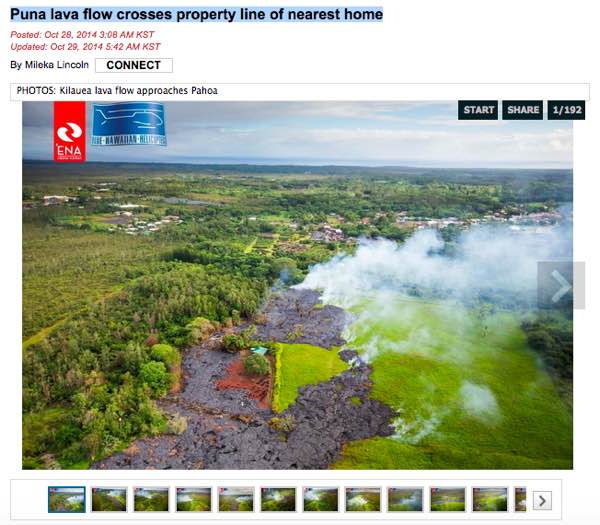
The current title : Puna lava flow crosses property line of nearest home
Read the full article here
Bárðarbunga update October 28 22:50 UTC
From geoscientist on duty
- About 80 earthquakes have been located in the Bárðarbunga area past 24 hours.
- Two quakes were over magnitude 5 in the northern caldera rim this morning, one M5.0 at 04:54 and the other M5.1 at 06:04. Additionally, few quakes over magnitude 4 have been observed, but manual processing of these is not finished.
- Over ten quakes were located in the northern part of the dike intrusion. The eruption was observed on webcams a few times during the night, last observation was at about seven and the eruption seems at a similar pace as before.
There was poor visibility in the area and the eruption not visible on webcams.
A beautiful video from the Bardarbunga Holuhraun eruption where normal video is combined with drone video and still images
Bárðarbunga update October 27 16:20 UTC
The volcanic eruption in Holuhraun continues with similar intensity.
- Seismic activity in Bardarbunga continues to be strong. Over 200 earthquakes have been detected in the caldera over the weekend. There off 44 larger then magnitude 3,0. The biggest ones were M5,3 at 05:54 on Sunday and at 01:05 tonight.
- The GPS station in the centre of Bardarbunga show that the subsidence of the caldera continues with similar rate as it has done over the last few weeks. Observation from air on Friday show that the depression in the caldera is 40 meters.
- Geothermal heat is increasing in Bardarbunga. A cauldron in the southeast corner of Bardarbunga has deepened about 25 meters over a one month period. The depression is considered to be linked to the depression of the Bardarbunga caldera.
- GPS measurements in the active area show minor changes.
- No change was detected in water monitoring that cannot be explained by changing weather.
*** Three scenarios are considered most likely:
- The eruption on Holuhraun declines gradually and subsidence of the Bardarbunga caldera stops.
- Large-scale subsidence of the caldera occurs, prolonging or strengthening the eruption on Holuhraun. In this situation, it is likely that the eruptive fissure would lengthen southwards under Dyngjujokull, resulting in a jokulhlaup and an ash-producing eruption. It is also possible that eruptive fissures could develop in another location under the glacier.
- Large-scale subsidence of the caldera occurs, causing an eruption at the edge of the caldera. Such an eruption would melt large quantities of ice, leading to a major jokulhlaup, accompanied by ash fall
Kilauea (Hawaii) update October 27 16:16 UTC
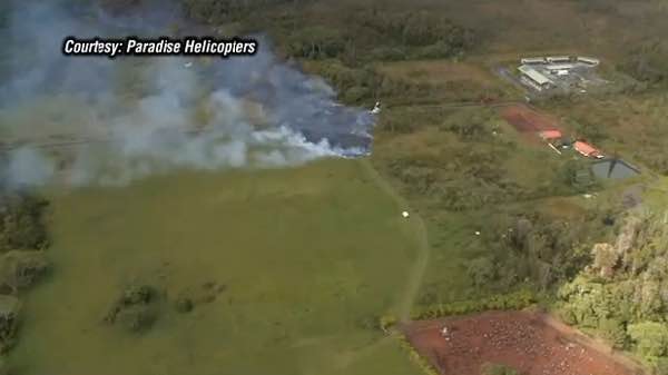
Kalapana home claimed by lava, now one man could lose his Pahoa house to Puna lava flow
The pictures may be yellowing with age, but for Alii Hauanio, the memories are vivid.
"It's so neat how memories just come back when you're looking at these photos -- remembering all the weekends that we spent down there camping and cleaning up the property, planting coconut trees and cutting the grass -- and then one day when my parents decided they were able to, we built a home," Hauanio described.
Hauanio's mother and father were papaya farmers. Their Kalapana beach home was a dream come true -- fueled by hard work and unwavering faith, but in 1991 a lava flow claimed their home.
"You could see it coming and so it was that time to prepare, yeah? For me, I was more amazed at how slow it moved. After it moved and passed you up, there's nothing there but pahoehoe. It's a different kind of devastation, I guess, it's not quick. It was slow," recalled Hauanio. "All the signs of what was prior is no more, it's gone."
Read the full article including video here
Nevado de Chiles - Cerro Negro de Maysquer October 27 16:25 UTC
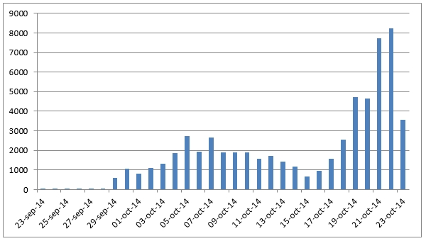
Rodger Wilson : Update from INGEOMINAS on the situation at the volcanoes. Most noteable are the still very high level of seismicity (over 8000 events recorded on Saturday!), and the now localized uplift on the south flank of the Chiles edifice.
El Servicio Geológico Colombiano a través de su Observatorio Vulcanológico y Sismológico de Pasto (SGC – OVSP), y el Instituto Geofísico de la Escuela Politécnica Nacional (IGEPN), instituciones encargadas del monitoreo de la actividad en la zona de los volcanes Chiles y Cerro Negro informan que:
Actividad Sísmica: El enjambre sísmico detectado desde el 29 de Septiembre de este año continúa presentando altos niveles de actividad (totalizando cerca de 81.000 sismos desde esa fecha). El día de ayer se registró 6.300 eventos, y en lo que va corrido del día de hoy (hasta las 5:00 p.m.) se tienen unos 3.600 eventos, destacándose en este día los sismos de la 00:40, 00:49, 05:32 y 11:24 a.m. con magnitudes de 3.6, 4.2, 3.7 y 3.5, respectivamente, reportados como sentidos. La ubicación de los epicentros se localiza a en un área entre 2 y 3.5 Km km al sur del volcán Chiles.
Deformación del terreno: El GPS de alta resolución del Instituto Geofísico, localizado al Sur-este del Volcán Chiles, muestra una deformación hacia el nor-occidente. Esta deformación es significativamente mayor a la observada en los meses anteriores y muy distinta que las medidas de otros puntos de la Red Nacional de Geodesia del Ecuador (RENGEO). Esto indica que existe una deformación localizada al sur del volcán Chiles. Medidas de deformación satelitales realizadas por personal de la JPL Caltech – NASA con información de la Agenzia Spaziali Italiane y Universitá Degli Studi Della Basilicata, mediante la técnica de interferometría (INSAR), confirman esta tendencia.
Estos dos hechos evidencian que tanto la fuente de intensa sismicidad, como la de deformación están relacionadas y asociadas a una posible intrusión magmática que aún no se manifiesta en superficie y localizada más precisamente en el flanco sur del volcán Chiles.
Hasta el momento, de acuerdo a sobrevuelo realizado por la Fuerza Aérea Colombiana el 22 de octubre y reconocimientos en campo efecutados por personal del Servicio Geológico Colombiano, no se observan anomalías en la superficie de esta zona, como por ejemplo actividad fumarólica o explosiones freáticas. Si se han observado deslizamientos como consecuencia del sismo del pasado 20 de octubre.
El SGC-OVSP y el IGEPN continúan mejorando el monitoreo instrumental en la zona, mediante la instalación de nuevas estaciones sísmicas, acelerográficas, de cámaras de video, entre otras.
MARTA LUCIA CALVACHE VELASCO
Directora Técnica
Kilauea (Hawaii) update October 26 13:34 UTC
Lava crosses the road in Hawaii
Hawaii News Now video news report
Kilauea (Hawaii) update October 26 13:30 UTC
Hawaii volcano flow on his destruction path to Pahoa village
HVO scientists conducted ground observations of the June 27th lava flow throughout the morning and afternoon of Saturday, October 25, 2014. Earlier that morning, at about 3:50 AM, HST, the narrow finger that had been moving rapidly downslope reached and crossed Apaʻa Street / Cemetery Road near the driveway to the Pāhoa cemetery. The lobe located to the southeast of the narrow finger, described in yesterday’s status report, is no longer advancing.
Over the course of the day, the advance rate of the narrow finger varied between 10 and 15 m/hr (11 to 16 yd/hr)—that’s equivalent to 240–360 m/day (260–390 yd/day). Through the morning, the flow moved downslope along the cemetery driveway before veering to the southeast into the adjoining pasture in the early afternoon.
As of 5 PM, the flow was about 90 m (100 yd) above the cemetery and 160 m (175 yd) downslope of Apaʻa Street, and it had an average width of about 40 m (45 yd).
The pasture between Apaʻa Street and the cemetery is characterized by gentle topography, but the slopes increase at or just below the cemetery. If the flow reaches this point, its advance rate may increase.
The pasture is located between two of the steepest decent paths plotted on HVO’s lava flow maps, and it is unclear at this point which path the flow will follow. Both paths, however, join just below the cemetery, so the overall flow path leading to Pāhoa Village Road is unchanged.
https://twitter.com/RowlandMore/status/526342004985593856
Bárðarbunga update October 24 21:40 UTC
@NatGeo Photo Contest has incredible landscapes as candidates! #Holuhraun #Bardarbunga http://t.co/1k4lUGSGh8 pic.twitter.com/8u4PyKsrHd
— EGU (@EuroGeosciences) October 24, 2014
Nevado de Chiles- Cerro Negro de Maysquer October 24 13:35 UTC
Rodger Wilson : IGN (Ecuador) issued this histogram of recent seismicity at the volcanoes today. Impressive!
Bárðarbunga update October 24 13:20 UTC
From the Scientific Advisory Board
The volcanic eruption in Holuhraun continues with similar intensity as last few weeks. The lava field is now 63
square kilometers.
- Seismic activity in Bardarbunga continues to be strong. Over 160 earthquakes have been detected in the caldera over the last two days. There off at least 15 larger then M4,0 and 45 between magnitude 3,0-3,9. The biggest ones were M4,8 at 13:21 on Wednesday and at 13:07 yesterday.
- Over 50 smaller earthquakes are detected in the dyke. The biggest was M1.9 at 02:48 tonight.
- The GPS station in the centre of Bardarbunga show that the subsidence of the caldera continues with similar rate as it has done over the last few weeks.
- GPS measurements in the active area show minor changes.
- No change was detected in water monitoring that cannot be explained by changing weather
Three scenarios are considered most likely:
- The eruption on Holuhraun declines gradually and subsidence of the Bardarbunga caldera stops.
- Large-scale subsidence of the caldera occurs, prolonging or strengthening the eruption on Holuhraun. In this situation, it is likely that the eruptive fissure would lengthen southwards under Dyngjujokull, resulting in a jokulhlaup and an ash-producing eruption. It is also possible that eruptive fissures could develop in another location under the glacier.
- Large-scale subsidence of the caldera occurs, causing an eruption at the edge of the caldera. Such an eruption would melt large quantities of ice, leading to a major jokulhlaup, accompanied by ash fall.
- Other scenarios cannot be excluded.
From the Icelandic Met Office:
- The Aviation Colour Code for Bardarbunga remains at ‘orange’.
- The next meeting will be held on Monday 27 of October.
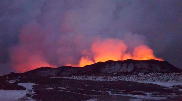
Image courtesy and copyright University of Iceland
EO-1 ALI satellite image from NASA & USGS of the lava on October 21st. White line shows lava extent pic.twitter.com/EywUYzR2ZB
— Univ. of Iceland (@uni_iceland) October 23, 2014
Nevado de Chiles- Cerro Negro de Maysquer October 22 15:05 UTC
Seismicity continues at the volcanoes today at rate of around 4 seismic events per minute. Event magnitudes range less than magnitude M4.0 for the most part, although "felt" events remain frequent (M>M2.0). INGEOMINAS/IGN report an increase in the rate of inflation of the volcano since Monday's M5.9 earthquake. Preparations for an eruption of unforseeable size continue.
INGEOMINAS has discontinued posting seismic records (of any of their volcanoes), so finding suitable seismograms of the activity is difficult. The best one I have located thus far is from Antisana volcano (Ecuador), some 165 miles distant. That volcano is seismically "quiet" enough to show for the most part, only the Chiles-Cerro Negro seismicity.
Bárðarbunga update October 22 15:00 UTC
From the Scientific Advisory Board
- Scientists in Holuhraun confirm that the volcanic eruption continues with similar intensity as last few days. The lava river runs from the northern end of the crater to the east with great force.
- Seismic activity in Tungnafellsjokull glacier had decreased but activity in Bardarbunga continues to be strong. At 8:36 Tuesday morning an M5,3 earthquake was measured in northern Bardarbunga. Over the last two days ten other earthquakes bigger then M4,0 were recorded in Bardarbunga and in total 31 earthquakes bigger then M3,0.
- Smaller earthquakes are measured in the dyke, most of them are in the area north of Dyngjujokull leading to the eruption site in Holuhraun.
- The GPS station in the centre of Bardarbunga show that the subsidence of the caldera continues with similar rate as before.
- GPS measurements show minor movements. No great changes were detected.
- No change was detected in water monitoring that cannot be explained by changing weather.
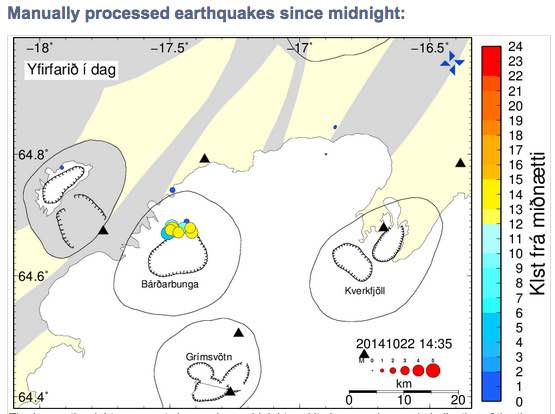
Bárðarbunga update October 21 15:46 UTC
from geoscientist on duty
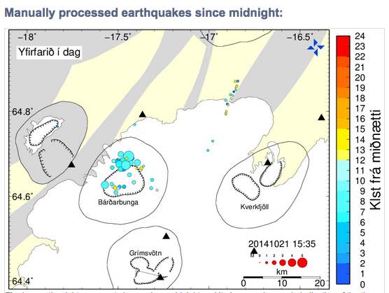
- Seismic activity in the Bárðarbunga system and volcanic activity at the eruption site in Holuhraun has been comparable to recent days.
During the last 24 hours around 70 earthquakes have been detected around the Bárðarbunga caldera rim, the strongest was magnitude 5.3 at 08:36 this morning on the northern rim.
- The event was preceded by a magnitude 4.7 in the same area just two minutes before.
- Four additional events exceeded magnitude 4 since the last report yesterday.
Earthquakes over M4.0 the last 24 hours:
20 Oct. M4.6 at 13:27
20 Oct. M4.1 at 13:30,
20 Oct. M4.7 at 13:31
20 Oct. M4.6 at 22:18
21 Oct. M 4.7 at 08:34
21 Oct. M 5.3 at 08:36
12 events were in the range of magnitude 3.0-3.9.
- The subsidence of the caldera continues at similar rates as the days before,
- no obvious step in subsidence was observed for the M5.3 earthquake this morning.
- Earthquake rates in the dyke intrusion are rather low, around 20 events have been detected in the last 24 hours, the strongest one was magnitude 1.4 yesterday at 23:31.
- All events in the dyke were located between the northern part of Dyngjujökull and the eruption site in Holuhraun.
- The eruption continues, visibility on webcams was limited this morning due to weather.
Nevado de Chiles- Cerro Negro de Maysquer October 21 08:15 UTC
INGEOMINAS has raised the alert level from yellow to orange at these long-dormant, twin volcanoes as seismicity has surged (over 1500 events!) over the past 24 hours (including a magnitude M5.6 earthquake).
Map of #Holuhraun lava field on Oct. 19th. It's currently 61 km2 and still growing. #Bardarbunga pic.twitter.com/5WrEOLFbm0
— Univ. of Iceland (@uni_iceland) October 20, 2014
Bárðarbunga update October 20 16:30 UTC
From geoscientist on duty
- Seismic activity at Bárðarbunga is still high.
- An earthquake, M5.1 occurred at 08:54 this morning in the northern rim of the caldera.
- Some earthquakes between 4 and 5 occurred the last 24 hours.
- The eruption site was visible on webcams in the night and this morning, but currently no visibility is in the area and nothing can be seen through webcams
Volcano Activity for the week of 8 October - 14 October 2014
Copahue | Central Chile-Argentina border
SERNAGEOMIN reported that two explosions from Copahue’s El Agrio Crater occurred at 0752 and 1349 on 11 October, and generated dark gray ash plumes that rose at most 3.6 km above the crater. Some minor explosions were detected after the second explosion. Incandescence in the vicinity of the crater was observed at night. The Alert Level was raised to Orange. Cameras near the volcano recorded dark gray ash plumes rising to a maximum height of 1.9 km and drifting 35 km NE on 12 October, 2.2 km and drifting E on 13 October, and 0.4 km and drifting E on 14 October. Minor explosions continued to be detected.
Mayon | Luzon (Philippines)
PHIVOLCS reported that during 8-12 October white plumes rose from Mayon's crater and drifted NW, NE, ESE, SE, and SSW. During an overflight of Mayon on 12 October volcanologists observed a 350-m-long lava flow traveling down the SE flank, on the E side of Bonga Gully. The report noted that the small number of volcanic earthquakes and rockfall signals recorded during the previous few days indicated slow lava extrusion from the crater and a slow-moving lava flow. The Alert Level remained at 3 (on a 0-5 scale).
Ontakesan | Honshu (Japan)
JMA reported that during 8-9 October ash emissions from Ontakesan continued. The plume turned white on 10 October, but during 10-14 October the emissions may have contained small amounts of ash. Tremor was below detection limits during 8-14 October. A news article from 12 October noted that the number of people killed in the 27 September eruption had reached 56; seven more were still missing. The Alert Level remained at 3 (on a scale of 1-5).
Poas | Costa Rica
OVSICORI-UNA reported that a strong phreatic eruption from the hot lake at Poás was recorded at 1745 on 8 October. The event lasted one minute and ejected material over 250 m above the crater lake’s surface. The seismic record indicated that it was the most energetic event so far in 2014.
Sinabung | Indonesia
The Darwin VAAC reported that an eruption from Sinabung, observed in the webcam at 1248 on 8 October, generated a pyroclastic flow. An ash plume rose to an altitude of 4.9 km (16,000 ft) a.s.l. (based on webcam views and wind models) and drifted E. Eruptions recorded at 0636 and 1107 on 9 October generated ash plumes that rose to an altitude of 6.1 km (20,000 ft) a.s.l. and drifted NE, based on webcam views and wind models. On 10 October satellite images and the webcam detected an ash plume drifting 55 km NE. An ash plume drifting SW at an altitude of 3 km (10,000 ft) a.s.l. was recorded by the webcam on 11 October. On 14 October an ash plume was again recorded by the webcam and rose to an altitude of 4 km (13,000 ft) a.s.l. and drifted SW.
Bárðarbunga update October 16 17:30 UTC
From geoscientist on duty
- During the last 24 hours, about 70 earthquakes have been detected at Bárðarbunga and a dozen in the northern part of the dike. This is somewhat less activity than 24 hours earlier.
- Two quakes over five in magnitude occurred at the northern caldera rim; an M5.4 at 11:16 yesterday and an M5.0 in the early hours of the morning, at 03:14 today. One earthquake M4.2 occurred later this morning, at 09:25, in a similar location.
- Observations of deep thudding sounds were received yesterday while the large earthquake occurred, possibly as a consequence thereof.
- Scientist went to Askja yesterday but found no signs of a rockfall, which could have caused the noises. Possibly the sounds were from jet aircrafts, passing at the same time.
Bárðarbunga update October 15 15:23 UTC
From the Scientific Advisory Board
- During last week the eruption continues at a similar intensity and with similar lava flow.
- Around 130 earthquakes have been measured in Bardarbunga over the last 24 hours, which is an increase of what has been the norm over the last two weeks.
- The GPS station in the centre of Bardarbunga is back on-line.
- The subsidence of the caldera continues with similar rate as before, which is 30-40 cm per day. The subsidence is mainly in the northeast part of the caldera. The subsidence of the caldera is estimated to be 0,75 km3.
- 13 earthquakes greater than M3.0 were recorded over the last 48 hours in or around the caldera. The largest one were M4.8 at 18:51 yesterday.
- Little seismic activity is now detected in the northern part of the dyke and around the eruption site.
- GPS measurements show minor movements. No great changes were detected.
- No change was detected in water monitoring that cannot be explained by changing weather.
Three scenarios are considered most likely:
- The eruption on Holuhraun declines gradually and subsidence of the Bardarbunga caldera stops.
- Large-scale subsidence of the caldera occurs, prolonging or strengthening the eruption on Holuhraun. In this situation, it is likely that the eruptive fissure would lengthen southwards under Dyngjujokull, resulting in a jokulhlaup and an ash-producing eruption. It is also possible that eruptive fissures could
develop in another location under the glacier.
- Large-scale subsidence of the caldera occurs, causing an eruption at the edge of the caldera. Such an eruption would melt large quantities of ice, leading to a major jokulhlaup, accompanied by ash fall.
- Other scenarios cannot be excluded.
From the Icelandic Met Office:
The Aviation Colour Code for Bardarbunga remains at ‘orange’.
Some spectacular images in @NatureNews's images of the month - space selfies & #Bardarbunga http://t.co/wBU9F1gvCI pic.twitter.com/NrobkSdY50
— Flo Bullough (@flo_dem) October 15, 2014
Bárðarbunga update October 12 20:54 UTC
From geoscientist on duty
The eruption: Webcameras show no significant changes in the eruption.
Earthquakes: Since 10:00 UTC yesterday (Saturday) two quakes over magnitude 5 occurred in Bárðarbunga. The first one M5.0 at 11:30 yesterday and M5.2 at 08:43 this morning. Both originated in the northern rim of the Bárðarbunga caldera. Additionally, four quakes over magnitude 4 were registered: Yesterday M4.7 at 19:33, M4.1 at 01:36 last night, M4.0 at 03:57 and M4.2 at 06:20. Over 100 quakes have been registered during past 24 hours in the caldera and about 25 in the northern part of the intrusion.
Gas pollution: Northeasterly winds are expected today (Sunday), so the pollution is expected towards south and southwest from the eruption. Polluted area is bounded by Faxaflói in the west and Mýrdalur in the east and is expected to extend north of Hofsjökull. Tomorrow (Monday) wind will be southerly and the pollution will go north.
Bárðarbunga update October 11 13:27 UTC
From geoscientist on duty @ 10:UTC
From now on a change is made in these reports from a geoscientist on duty, and they will be published daily at about 10:00 UTC. This may be changed if the eruption changes significantly.
- The eruption continues with the same lava flow rate as in past weeks.
Seismicity is similar to previous days:
- There is low activity in the dyke intrusion. Around 20 earthquakes have occurred during the last 24 hours, all within magnitude 1.5 and in the northern part of the intrusion between the eruption site and to the south some kilometers under Dyngjujökull glacier.
- About 80 earthquakes were detected on the caldera rim of Bárðarbunga. The largest earthquakes were at 11:26 and 23:51 yesterday, both of magnitude 4.8. Earthquakes of magnitude 4.7 and 4.5 also occurred and seven between 3.0 and 3.9. Most activity was on the northern caldera rim.
GPS (no significant changes):
- Minor movements of GPS stations in the area.
- Subsidence of the caldera continuing at similar rate.
Water monitoring: No changes.
Gas forecast (latest forecast 09:32 UTC):
- Today (Saturday) and tomorrow (Sunday): Northeasterly winds are expected with the possibility of gas pollution south and southwest of the eruption site in an area from Hellisheiði in the west to Hornafjörður in the east.
Volcano Activity for the week of 1 October - 7 October 2014
Bardarbunga Iceland
See our own updates on this page
Copahue | Central Chile-Argentina border
The Buenos Aires VAAC reported that during 6-7 October diffuse steam-and-gas emissions from Copahue detected in satellite images contained a small amount of ash. The webcam showed that the emission source was near the summit.
Lewotobi | Flores Island (Indonesia)
Based on analysis of satellite images and wind data, the Darwin VAAC reported that on 6 October a narrow, low-level ash plume from Lewotobi rose to an altitude of 3 km (10,000 ft) a.s.l. and drifted 185 km WNW.
Mayon | Luzon (Philippines)
PHIVOLCS reported that during 1-7 October the seismic network at Mayon recorded 0-7 rockfall events per day. White steam plumes drifted SSE, ESE, and NW. Alert Level remained at 3 (on a 0-5 scale).
Ontakesan | Honshu (Japan)
JMA reported that ash emissions from Ontakesan likely continued during 1-7 October. The plume height could not be determined due to poor visibility although on 7 October observers noted that the plume rose 300 m above the crater rim and drifted E. Seismic levels fluctuated; tremor continued to be detected. A news article from 8 October noted that the number of people killed in the 27 September eruption had reached 55; nine were still missing. The Alert Level remained at 3 (on a scale of 1-5).
Sheveluch | Central Kamchatka (Russia)
KVERT reported that during 26 September-3 October lava-dome extrusion onto Sheveluch’s N flank was accompanied by ash explosions, incandescence, hot avalanches, and fumarolic activity. Satellite images detected a thermal anomaly over the dome during 27-29 September and 2 October. Two explosions on 2 October generated ash plumes that rose to an altitude of 4 km (13,100 ft) a.s.l. and drifted 220 km WSW. The Aviation Color Code remained at Orange.
Sinabung | Indonesia
Based on reports from PVMBG, BNPB reported four eruptions from Sinabung on 5 October. The first one occurred at 0146, and produced a pyroclastic flow that traveled 4.5 km S and an ash plume that rose 2 km. The next three events, at 0638, 0736, and 0753, all generated pyroclastic flows that traveled 2.5-4.5 km S. The fourth event also produced an ash plume that rose 3 km. A news article stated that pyroclastic flows from a fifth event at 0900 were smaller, but again traveled 4.5 km after a sixth event at 1200.
According to the Darwin VAAC a low-level eruption recorded by the PVMBG webcam generated a pyroclastic flow on 6 October; some of the ash rose higher and drifted E. The Jakarta MWO noted that an ash plume rose to an altitude of 5.2 km (17,000 ft) a.s.l. and drifted S on 7 October. Cloud cover prevented satellite observations. A news article posted on 8 October noted that eruptions in the previous four days caused some evacuations.
Bárðarbunga update October 10 15:54 UTC
From the Scientific Advisory Board
During last week the eruption continues at a similar intensity and with similar lava flow as previous weeks.
- The subsidence of the Bardarbunga caldera continues with similar rate.
- 13 earthquakes greater than M3.0 were recorded since noon on Wednesday in or around the caldera. The largest ones were M5.2 at 15:24 on Wednesday and at 21:22 last night.
- Very little seismic activity is now detected in the northern part of the dyke and around the eruption site.
- GPS measurements show minor movements. No great changes were detected.
- No change was detected in water monitoring that cannot be explained by changing weather.
Three scenarios are considered most likely:
- The eruption on Holuhraun declines gradually and subsidence of the Bardarbunga caldera stops.
- Large-scale subsidence of the caldera occurs, prolonging or strengthening the eruption on Holuhraun. In this situation, it is likely that the eruptive fissure would lengthen southwards under Dyngjujokull, resulting in a jokulhlaup and an ash-producing eruption. It is also possible that eruptive fissures could develop in another location under the glacier.
- Large-scale subsidence of the caldera occurs, causing an eruption at the edge of the caldera. Such an eruption would melt large quantities of ice, leading to a major jokulhlaup, accompanied by ash fall.
Other scenarios cannot be excluded.
From the Icelandic Met Office:
- The Aviation Colour Code for Bardarbunga remains at ‘orange’.
The next meeting of the Scientific Advisory Board will be held on Monday 13 October.
 Below a fine time lapse sequence of the Bardarbunga webcam
Sinabung, Sumatra, Indonesia October 10
The day in pictures http://t.co/mfkKWev9NE pic.twitter.com/PxzAw8P7lJ
— BBC News (World) (@BBCWorld) October 10, 2014
Kilauea (Hawaii) update October 9 21:17 UTC
The June 27 lava flow is continuing its march toward Pahoa, moving nearly 200 feet since Wednesday.
An overflight Thursday morning showed that the flow front remains active and has advanced some 65 yards since Wednesday, Civil Defense officials said. The narrow flow front is moving northeast along the tree line and may begin to enter areas of lighter vegetation.
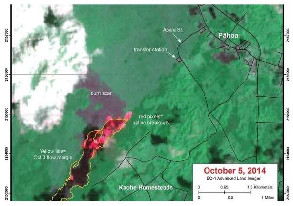
During the past week, the lava has advanced approximately 130 yards per day, according to the Hawaiian Volcano Observatory. At this rate, the lava flow could reach Apaa Street in about 14 days. The flow is currently 0.9 miles from Apaa Street and 1.6 miles from Pahoa Village Road.
The burning activity is producing a significant amount of smoke resulting in moderate to light smoke conditions. A light trade wind is blowing out of the northeast.
Read the full article here
Bárðarbunga update October 9 18:03 UTC
Isn't this an amazing picture ?
This Icelandic volcano eruption made for an amazing Northern Lights display: http://t.co/5D0XVZJx6N #ttot pic.twitter.com/ZOypjHoPh7
— Condé Nast Traveler (@CNTraveler) October 8, 2014
Bárðarbunga update October 9 08:41 UTC
Map of new Holuhraun lava field shows it's ~55 km2 by now. Rough estimate of volume ~0.77 km3
Mount Ontake volcano (Japan) deadly eruption October 8
Death toll reaches 55
Japanese rescue workers have uncovered another body on Mount Ontake in Japan, bringing the total death toll from the volcanic eruption to 55 with nine people still missing, Japanese news agency Kyodo reported Wednesday.
The search operation resumed for the first time in three days since the eruption of the 3,067-meter (10,062-foot) volcano, according to Kyodo. Search operations were suspended on October 5 amid forecasts of a severe typhoon, Phanfone, to hit the area. (Source Ria Novosti)
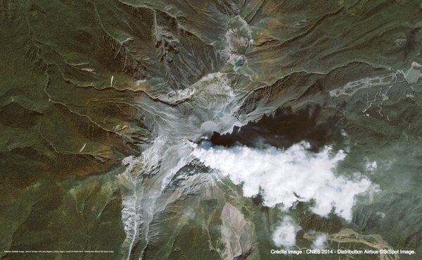
Steam plume of Ontake volcano 3 days after the initial deadly eruption as photographed from a spot satellite - Image courtesy CNES
Bárðarbunga update October 8 08:41 UTC
From the geoscientist on duty this morning
- Ten earthquakes have occurred in the northwestern part of Vatnajökull since midnight and almost 30 since 19:00 yesterday evening, most of them in Bárðarbunga.
- The largest earthquake since 19:00 yesterday was M3.9 at 03:37.
- It is cloudy in the area and the eruption has not been seen in webcams since 01:00. At that time it looked similar as the last days.
New Zealand's earthquake deep drilling project underway (October 8)
A deep-drilling project into one of the world's most dangerous earthquake faults is now underway on New Zealand's South Island.
Scientists from around the world have gathered at the drill site near Whataroa, north of Franz Josef glacier, for the rare opportunity to glimpse the inner workings of the Alpine Fault. The island-spanning fault unleashes a great earthquake every two to four centuries, with the average time between temblors about 330 years. The most recent earthquake, in 1717, was an estimated magnitude 8.1.
Read the full article here
Kilauea (Hawaii) update October 7 12:33 UTC
Awful times for house owners in a suburb of Pahoa, Hawaii, Hawaii
If the lava would continue on the same path than the last couple of weeks and at the same speed than today, it will destroy their houses in approximately 16 days!!
Civil Defense officials, in conjunction with the Federal Aviation Administration, have restricted the airspace above the leading edge of the flow in response to increased traffic of sightseers and media personnel.
Official USGS report based on yesterdays overflight data :
The June 27th flow remains active, with a narrow flow about 115 m (230 ft) wide moving downslope about 120 m/day (390 ft/day) since October 3. The leading edge of the flow is 1.9 km (1.2 mi) upslope from Apa`a St. along the steepest descent path and 1.7 km (1.1 mi) upslope from Apa`a St. along a straight line. At the average rate of advancement of 120 m/day, the lava could reach Apa`a St. in about 16 days. The advance rate of the June 27th flow has varied significantly during the past month, meaning this projection is subject to change. Our next overflight is scheduled for Wednesday, October 8. Pāhoa town is in the Puna District of the County of Hawai`i.
[Lava flow]
- The June 27th lava flow continued to advance northeast since October 3 at about 120 m/day (390 ft/day). The leading edge is now about 1.7 km (1.1 mi) straight-line
- The June 27th lava flow from the Pu‘u ‘Ō‘ō vent is active, and lava is being supplied to the flow front, which is slowly advancing downslope toward Pāhoa.
Bárðarbunga update October 7 10:51 UTC
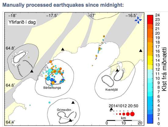
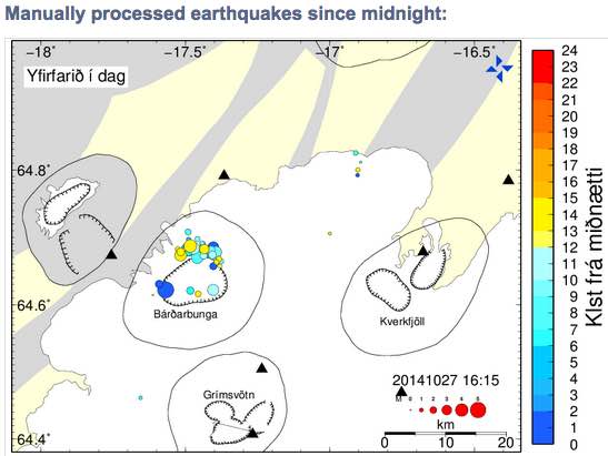
Update 10:54 UTC : Their was a strong M5.5 at a depth of 7.5 km at the edge of the Bardarbunga caldera! (biggest bullet in the map below)
From geoscientist on duty this morning
- Since 19:00 yesterday almost 30 earthquakes have occurred in Bárðarbunga, thereof more than 15 since midnight. Three were larger than M4:
00:33 M4.5
03:52 M5.0
06:07 M4.0
At 22:00 last night one earthquake, M3.8 occurred.
- Very few earthquakes were located in the dike. The largest one, M2.7, occurred at 19:29 last night.
- Strong wind was in the area and that can have increased the number of small events. Later in the night the wind has been going down.
- The eruption can't be seen through webcams. Just for a short while in the night it could be seen and looked similar as last days.


